Île d'Aix
| Île d'Aix | |
|---|---|
 Île d'Aix od jihozápadu | |
 Île d'Aix | |
| Lokalizace | Biskajský záliv |
| Stát | |
| • Region | Poitou-Charentes |
| • Departement | Charente-Maritime |
| • Arrondissement | Rochefort |
| • Kanton | Rochefort-Nord |
| • Obec | Île-d'Aix |
| Topografie | |
| Zeměpisné souřadnice | 46°0′46″ s. š., 1°10′21″ z. d. |
| Osídlení | |
| Počet obyvatel | 219 (2007) |
| Používané jazyky | francouzština |
| Některá data mohou pocházet z datové položky. | |
Île d'Aix je francouzský ostrov v Biskajském zálivu. Leží přibližně ve středu pertuis d'Antioche naproti ústí řeky Charente severozápadně od města Rochefort.
Geografie
Île d'Aix je malý plochý ostrov tvaru srpku, je široký 600 metrů a dlouhý 3 kilometry. Od pevniny je oddělen 6 kilometrů širokou úžinou. Ostrov je přístupný jen po moři.
Historie
Ostrov byl silně opevněn. V dubnu 1809 zde Britové svedli vítěznou námořní bitvu nad loďstvem viceadmirála Zacharie Allemanda. Roku 1815 odtud odplul Napoleon Bonaparte na brize L’Épervier.
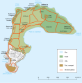 Mapa ostrova
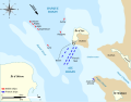 Bitva u ostrova Aix
Externí odkazy
 Obrázky, zvuky či videa k tématu Île d'Aix na Wikimedia Commons
Média použitá na této stránce


Carte Île-d'Aix.svg
Autor: Mutichou, Licence: CC BY-SA 3.0
Map of Île-d'Aix, Charente-Maritime, France.
Autor: Mutichou, Licence: CC BY-SA 3.0
Map of Île-d'Aix, Charente-Maritime, France.
PixAile3.jpg
Autor: Pierre Mairé, Licence: CC BY-SA 3.0
The Island of Aix seen from the air from the south-west at dusk. Aix is located at the mouth of the Charente River on the west coast of France.
Autor: Pierre Mairé, Licence: CC BY-SA 3.0
The Island of Aix seen from the air from the south-west at dusk. Aix is located at the mouth of the Charente River on the west coast of France.

Battle of Basque Roads 11 April.svg
Autor: BarretBonden, Licence: CC BY-SA 3.0
Map of the Battle of Basque Roads, 1809; a naval battle of the Napoleonic wars fought between the British and the French. The map illustrates the position of the anchored French fleet south of the Île-d'Aix shortly before the British launched a fire ship attack on the night of 11 April.
France relief location map.jpg
Autor: Eric Gaba (Sting - fr:Sting), Licence: CC BY-SA 4.0
Blank physical map of metropolitan France for geo-location purpose.
Scale : 1:14 816 000 (accuracy : about 3,7 km) for the bathymetry. More maps of France, view → Commons Atlas of France.
Autor: Eric Gaba (Sting - fr:Sting), Licence: CC BY-SA 4.0
Blank physical map of metropolitan France for geo-location purpose.
Scale : 1:14 816 000 (accuracy : about 3,7 km) for the bathymetry. More maps of France, view → Commons Atlas of France.