Čelo ledovce


Čelo ledovce je konec ledovce v daném okamžiku. Ačkoli se ledovce pozorovateli mohou zdát nehybné, ve skutečnosti jsou v trvalém pohybu a čelo ledovce vždy postupuje nebo ustupuje. Umístění čela je často přímo spojeno s hmotnostní bilancí ledovce, která je daná množstvím sněžení, ke kterému dochází v akumulační zóně ledovce, ve srovnání s množstvím, které je roztálo v ablační zóně. Na polohu čela ledovce má vliv také lokální nebo regionální změna teploty v průběhu času.[1]
Sledování
Monitorování změny polohy čela ledovce je metoda sledování pohybu ledovce. Konec čela ledovce se pravidelně měří z pevného místa v sousedním podloží. Rozdíl v umístění čela ledovce měřeného z této pevné polohy v různých časových intervalech poskytuje záznam o změně ledovce. Podobným způsobem sledování změny ledovce je porovnávání fotografií polohy ledovce v různých časech.[2]
Tvar čela ledovce ovlivňuje mnoho faktorů. Pokud ledovec ustupuje, je obvykle mírně svažitý, protože tající ledovec má tendenci převzít tento tvar. Existuje však řada faktorů, které mění tento typický tvar, včetně přítomnosti tepelných polí a různých napětí, která způsobují praskání a tání, což má za následek telení a další různé formy.[3]
Galerie
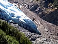
Čelo ledovce s relativně ostrými obrysy – Bossonský ledovec poblíž Chamonix-Mont-Blanc
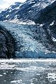
Čelo ledovce v Glacier Bay na Aljašce

Satelitní snímek čela ledovce Viedma v Chile
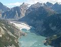
Ledovec Johns Hopkins na Aljašce
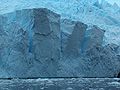
Čelo ledovce na Antarktickém poloostrově
Odkazy
Reference
V tomto článku byl použit překlad textu z článku Glacier terminus na anglické Wikipedii.
- ↑ All About Glaciers - Glacier Terminus [online]. National Snow and Ice Data Center [cit. 2007-11-25]. Dostupné v archivu pořízeném z originálu dne 2007-12-21. (anglicky)
- ↑ Techniques for studying glacier change [online]. [cit. 2007-03-21]. Dostupné v archivu pořízeném z originálu dne 2006-09-03. (anglicky)
- ↑ Glossary of Selected Glacier and Related Terminology [online]. USGS [cit. 2007-11-25]. Dostupné online. (anglicky)
Související články
Externí odkazy
 Obrázky, zvuky či videa k tématu čelo ledovce na Wikimedia Commons
Média použitá na této stránce

(c) Janquen from en.wikipedia.org, CC BY-SA 3.0
Glacier Bay taken by myself in September 2004. Quentin Goodman

Autor: Mabit1, Licence: CC BY-SA 4.0
Gletscherzunge aus blankem Eis mit relativ scharfen Konturen - der Glacier des Bossons bei Chamonix (2003)

This image shows the termini of the glaciers in the Bhutan-Himalaya. Glacial lakes have been rapidly forming on the surface of the debris-covered glaciers in this region during the last few decades. USGS researchers have found a strong correlation between increasing temperatures and glacial retreat in this region.
According to a joint press release issued by NASA and the U.S. Geological Survey, the great majority of the world’s glaciers appear to be declining at rates equal to or greater than long-established trends. This image from the ASTER (Advanced Spaceborne Thermal Emission and Reflection Radiometer) instrument aboard NASA’s Terra satellite shows the termini of the glaciers in the Bhutan-Himalaya. Glacial lakes have been rapidly forming on the surface of the debris-covered glaciers in this region during the last few decades.


The terminus of the Viedma Glacier, 2 kilometers across where it enters Lake Viedma