Čtyři rohy (Kanada)
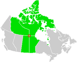
Čtyři rohy (Four Corners) je místo (čtyřmezí) v Kanadě, kde se sbíhají hranice provincií Saskatchewan a Manitoba a spolkových teritorií Severozápadní teritoria a Nunavut. Nachází se na šedesátém stupni severní šířky a stodruhém stupni západní délky nedaleko jezera Kasba Lake. Okolí je porostlé tajgou. V roce 1962 byl na místě vztyčen metr vysoký hliníkový obelisk.[1]
Místo není zdaleka tolik navštěvované jako populární Čtyři rohy v USA – vzniklo až v roce 1999 při oddělení Nunavutu od Severozápadních teritorií a leží v neobydlené krajině mimo dopravní trasy.[2] Nejbližším sídlem je Points North Landing.
Reference
Externí odkazy
 Obrázky, zvuky či videa k tématu Čtyři rohy na Wikimedia Commons
Média použitá na této stránce
A map highlighting the corners of the four Canadian provinces and territories which theoretically meet.
Autor: Mlugassy, Licence: CC BY-SA 3.0
The obelisk monument marking the intersection of Manitoba, Saskatchewan, Northwest Territories, and hypothetically Nunavut. The face reading "Manitoba Saskatchewan Boundary Commission 1962", faces the Manitoba-Saskatchewan border to the south, and the wooden structure in the background is in the Northwest Territories, and theoretically Nunavut.


