Šiveluč
| Šiveluč | |
|---|---|
 Šiveluč z ISS | |
| Vrchol | 3307 m n. m. |
| Prominence | 3 168 m |
| Poloha | |
| Světadíl | Asie |
| Stát | |
| Souřadnice | 56°39′13″ s. š., 161°21′47″ v. d. |
 Šiveluč Šiveluč, Rusko | |
| Typ | stratovulkán |
| Erupce | 2023 (momentálně činná) |
| Hornina | sopečné |
| Některá data mohou pocházet z datové položky. | |
Šiveluč (rusky Шивелуч) je nejsevernější aktivní sopka v Kamčatském kraji v Rusku. Občas je nazývána Ševeluč (rusky Шевелуч). Je jednou z největších a nejaktivnějších sopek Kamčatky.
Historie
Šiveluč se začal tvořit zhruba před 60 000 až 70 000 lety (2010). V holocénu proběhlo alespoň 60 velkých erupcí. Během holocénu proběhlo nejintenzivnější období vulkanismu — včetně častých velkých a mírných erupcí — 6500–6400 př. n. l., 2250–2000 př. n. l. a 50–650 n. l. To se dělo současně s vrcholy sopečné činnosti dalších kamčatských sopek. Současné období činnosti sopky začalo zhruba 900 let př. n. l. Od té doby se intenzivní a mírnější období sopečné činnosti střídaly v 50letých až 400letých údobích. Katastrofální erupce se vyskytly v letech 1854 a 1956, kdy došlo ke zřícení velké části sopky a vytvořil se ničivý sesuv.
Poslední erupce Mladého Šiveluče začala 15. srpna 1999 a trvala přinejmenším do roku 2010.
6. dubna 2014 došlo v sopce Šiveluč k výstupu popela do výšky až 6 km[1]. Z toho důvodu byl v leteckém provozu pro danou oblast nastaven oranžový kód[2].
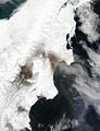
V úterý 11. dubna 2023 těsně po půlnoci místního času vulkán vybuchl a vychrlil popel do výšky až 20 km, na vesnice vzdálené 50 až 70 km a na plochu 108 000 km², nejvíce západním a jižním směrem. V okolních vesnicích vrstva popela dosahovala až 8,5 cm – nejvíce za šedesát let. Bylo vydáno varování před sopečnými bahnotoky (lahary).[3][4]
Popis
Šiveluč patří ke skupině sopek Ključevskaja. Sama sestává ze stratovulkánu Starý Šiveluč (Старый Шивелуч), z prastaré kaldery a aktivního Mladého Šiveluče (Молодой Шивелуч), s výškou 2800 metrů. Šiveluč je jednou z největších a nejaktivnějších vulkanických struktur. Jedná se o stratovulkán složený ze střídajících se vrstev zpevněného popela, utuhlé lávy a vulkanických hornin.
Nejbližší sídlo je Ključi, leží asi 50 km jihozápadně od sopky. Sídlo je dostatečně malé, aby mohlo být včas evakuováno v případě větší erupce.
Galerie
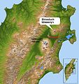
Poloha Šiveluče
Erupce Šiveluče, 9. května 2004.

Šiveluč vypustil malý sloupec páry.

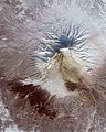
Šiveluč, 13. února 2010.

Šiveluč, 7. září 2010.
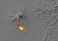
Tepelná stopa pyroklastického proudu na Šiveluči, leden 2011.
Snímek ve falešných barvách ukazuje pozůstatky velkého pyroklastického proudu na svazích sopky.
Pokračující erupce 12. dubna 2023.
Odkazy
Reference
V tomto článku byl použit překlad textu z článku Shiveluch na anglické Wikipedii.
- ↑ NEWIZV.RU. Камчатский вулкан Шивелуч выбросил пепел на высоту 6 км [online]. Новые Известия, 2014 [cit. 2014-04-06]. Dostupné v archivu pořízeném dne 2014-04-07. (rusky)
- ↑ AEX.RU. Вулкану Шивелуч на Камчатке присвоен оранжевый авиационный код [online]. Aviation Explorer, 2014 [cit. 2014-04-06]. Dostupné online. (rusky)
- ↑ KILIÁN, Karel. Na Kamčatce vybuchla sopka Šiveluč. Vyvrhla prach do výšky 20 km a ohrožuje leteckou dopravu. VTM.cz [online]. Mladá fronta, 2023-04-12 [cit. 2023-04-12]. Dostupné online.
- ↑ JEMELKA, Petr; ČTK. Unikátní záběry: Sopka na Kamčatce proměnila den v noc a z vesnic udělala tiramisu. Novinky.cz [online]. Seznam.cz [cit. 2023-04-12]. Dostupné online.
Externí odkazy
 Obrázky, zvuky či videa k tématu Šiveluč na Wikimedia Commons
 - Šiveluč – webkamera
- Google Maps satelitní snímek
Média použitá na této stránce


This is a solid red equilateral triangle, which can symbolize or indicate many things, including the the symbol for fire in the books by Franz Bardon.


Shiveluch Volcano at Russia’s Kamchatka Peninsula on 25-02-2011, as recorded in false-color by Advanced Spaceborne Thermal Emission and Reflection Radiometer (ASTER) on NASA’s Terra satellite. Remnants of a large pyroclastic flow is seen on its slopes. ASTER detected heat from the flow during or shortly after an event on 25-01-2011. Note how the heat signatures from January line up with the dark surface deposits visible on February 25; those deposits cover more than 10 square kilometers (4 square miles). Light brown ash covers the snow above the flow deposits, and a tiny plume rises from Shiveluch’s growing lava dome. Vegetation surrounding the volcano is colored dark red.

Shiveluch Volcano, Russia eruption on May 9, 2004
image description here
Image Courtesy: NASA/MODIS Rapid Response SystemAutor: Uwe Dedering, Licence: CC BY-SA 3.0
Location map of Russia.
EquiDistantConicProjection : Central parallel :
* N: 54.0° N
Central meridian :
* E: 100.0° E
Standard parallels:
* 1: 49.0° N
* 2: 59.0° N
Made with Natural Earth. Free vector and raster map data @ naturalearthdata.com.

Evidence of current activity appeared at the summit of Shiveluch Volcano on Russia’s Kamchatka Peninsula in mid-February 2010. A plume shot skyward while dark rivulets flowed down the volcano’s snowy slopes. The Advanced Spaceborne Thermal Emission and Reflection Radiometer (ASTER) on NASA’s Terra satellite captured this image on February 13, 2010.
The plume, which may consist of a combination of water vapor, volcanic ash, and volcanic gases, ranges in color from white to charcoal gray. Dark flows on the snowy slopes could result from lava, mudflows, or pyroclastic flows—avalanches of hot gas and debris.
Shiveluch (also spelled Sheveluch) is a stratovolcano—a steep-sloped volcano composed of alternating layers of lava, ash, and rocks produced by previous eruptions. It ranks among Kamchatka’s most active volcanoes. In mid-February 2010, the Alaska Volcano Observatory reported that activity at Shiveluch, including a lava flow as well as ash plumes reaching an altitude of 5.2 kilometers (17,000 feet), had been elevated above background levels for days.
The Shiveluch Volcano on Russia’s Kamchatka Peninsula released a small plume of vapor as the Advanced Spaceborne Thermal Emission and Reflection Radiometer (ASTER) on NASA’s Terra satellite passed overhead. The steam plume blowing northward away from the volcano nearly matches the snowy white surface of the surrounding land, but ash fall from earlier eruptions has stained the volcano’s slopes dark brown. In this kind of false-colour image, vegetation appears red.
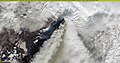
Photo of the Shiveluch volcano from the International Space Station.

A sideways view of kamchatka.

Autor: Sentinel Hub, Licence: CC BY 2.0
Contains modified Copernicus Sentinel data [2023], processed by Sentinel Hub/Pierre Markuse
Shiveluch Volcano, Kamchatka, Russia - 12 April 2023
Iimage is about 72 kilometres wide.
Follow us on Twitter!
Try out the EO Browser!
This image shows the heat signature of a pyroclastic flow on Shiveluch as measured in thermal infrared light. The white area at the lava dome is very hot, while the red areas on the edge of the flow are just warmer than the surrounding snow.