Alboránské moře
| Alboránské moře | |
|---|---|
 Gibraltarský průliv a Alboránské moře | |
| Šířka | 150 km |
| Délka | 350 km |
| Zeměpisné souřadnice | 36°0′0″ s. š., 3°0′0″ z. d. |
| Nadřazený celek | Středozemní moře |
| Sousední celky | Gibraltarský průliv, Středozemní moře |
| Světadíl | Evropa, Afrika |
| Stát | Španělsko, Maroko, Alžírsko |

Alboránské moře (španělsky Mar de Alborán) je moře tvořící nejzápadnější část Středozemního moře.
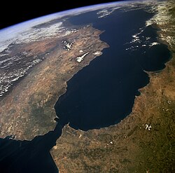
Na západě končí Alboránské moře u Gibraltaru na východním konci Gibraltarského průlivu, kterým je propojeno s Atlantským oceánem. Na severu je ohraničeno španělským pobřežím Pyrenejského poloostrova, jeho jižní africký břeh patří z části Maroku a z části Alžírsku. Východní hranice je Mezinárodní hydrografickou organizací definována jako spojnice mysu de Gata (36°47′ s. š., 2°6′ z. d.) ve Španělsku a mysu Fegalo v Africe (35°36′ s. š., 1°12′ z. d.).[1]
Povrchové proudy v Alboránském moři tečou východním směrem z Atlantského oceánu do Středozemního moře, zatímco hlubinné proudy tečou v protisměru. Fauna je směsicí středomořských a atlantských druhů. Je zde mnoho delfínů skákavých, žije zde poslední zbytek středomořských sviňuch obecných a také je zde nejvýznamnější evropské středisko karet obecných.
Jsou zde také zastoupeny pro rybolov významné sardinky a mečouni.
K významnějším ostrovům patří španělský ostrov Alborán.
Reference
V tomto článku byl použit překlad textu z článku Alboran Sea na anglické Wikipedii.
- ↑ Limits of Oceans and Seas, 3rd edition [online]. International Hydrographic Organization, 1953 [cit. 2010-02-07]. Dostupné v archivu pořízeném dne 08-10-2011.
Externí odkazy
 Obrázky, zvuky či videa k tématu Alboránské moře na Wikimedia Commons
Média použitá na této stránce
Autor: NormanEinstein, Licence: CC BY-SA 3.0
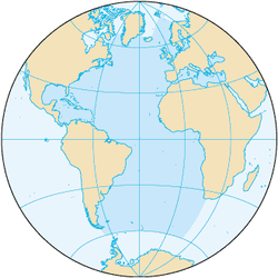
Map showing the location of the Alboran Sea, a part of the Mediterranean Sea, between Spain and Morocco.
The Strait of Gibraltar provides a natural physical barrier between the countries of Spain (north) and Morocco (south). In geologic terms, the 10-mile (16-kilometer) strait that separates the two countries, as well as Europe and Africa, is located where the two major tectonic plates—the Eurasian Plate and the African Plate—collide. This high-oblique, northeast-looking photograph shows the mountainous northern coast of Morocco and the coastal mountains of southern Spain, including the dagger-shaped, snow-covered Sierra Nevada Mountains of southeastern Spain. The Guadalquivir River flows from east to west along the base of the Sierra Morena Mountains in southern Spain. The famous British city of Gibraltar is located on the wedge-shaped peninsula on the east side of the bay in the southernmost protrusion of Spain. The city of Ceuta is a Spanish enclave on the extreme northeastern coast of Morocco. Ceuta, a free port with a large harbor, has remained under Spanish control since 1580.


