Anglická metropolitní hrabství
| Anglická metropolitní hrabství | |
|---|---|
| Geografie | |
 (c) Nilfanion and Dr Greg, CC BY-SA 3.0 Mapa hrabství | |
| Obyvatelstvo | |
| Počet obyvatel | 1,2 - 2,8 milionu |
| Správa regionu | |
| Stát | |
| Kategorie | Hrabství |
| Umístění | Regiony |
| Podřízené celky | Metropolitní distrikty (počet: 6) |
| Vznik | 1. dubna 1974 |
| Některá data mohou pocházet z datové položky. | |
Metropolitní hrabství (metropolitan county) představují spolu s nemetropolitními hrabstvími jeden ze čtyř stupňů správního členění Anglie. Vzhledem k různým historickým souvislostem a vývoji legislativy existuje několik typů administrativních celků na této úrovni.
Historie
Vznik
Současný systém metropolitních a nemetropolitních hrabství vešel v platnost 1. dubna 1974 a nahradil původní administrativní hrabství, která byla zrušena. Velký Londýn vznikl roku 1965 na základě jiné legislativy.
Struktura
Tato hrabství byla založena jako dvoustupňový systém samosprávy. Jednotlivé agendy byly rozděleny mezi rady hrabství a rady jednotlivých distriktů. Metropolitní distrikty měly větší pravomoci (např. vzdělání a sociální služby) než distrikty nemetropolitní. Metropolitní hrabství měly být orgánem strategického rozvoje pro veřejnou dopravu, záchrannou službu, civilní ochranu, hospodaření s odpadem a strategický rozvoj jednotlivých měst.
Zrušení rad hrabství
Rady těchto hrabství byly roku 1986 zrušeny. Tato hrabství se stále používají pro některé administrativní nebo statistické účely a stále existují jako ceremoniální hrabství. Většina pravomocí těchto hrabství byla převedena na jejich distrikty, která tak nyní existují jako celky zvané Unitary authority. Správa některých služeb například záchranné služby, požární ochrany, civilní obrany a veřejné dopravy je ale stále zajišťována jednotlivými radami distriktů společně na úrovni oblasti hrabství.
Současnost
V současnosti existuje 6 metropolitních hrabství (viz tabulka). Počet obyvatel těchto hrabství je v rozsahu 1,2 až 2,8 milionu. Hustota obydlení hrabství je v rozsahu 800 (South Yorkshire) až do 2 800 (West Midlands) obyvatel na km². Jednotlivé distrikty mají od 500 (Doncaster) až do 4 000 (Liverpool) obyvatel na km². V současnosti obyvatelé metropolitních hrabství tvoří asi 22% obyvatel Anglie.
Hrabství a distrikty
Současná metropolitní hrabství a jejich distrikty:
| Metropolitní hrabství | Metropolitní distrikty |
|---|---|
| Velký Manchester | Manchester, Salford, Bolton, Bury, Oldham, Rochdale, Stockport, Tameside, Trafford, Wigan |
| Merseyside | Liverpool, Knowsley, Sefton, St Helens, Wirral |
| South Yorkshire | Sheffield, Barnsley, Doncaster, Rotherham |
| Tyne and Wear | Newcastle upon Tyne, Sunderland, Gateshead, South Tyneside, North Tyneside |
| West Midlands | Birmingham, Coventry, Wolverhampton, Dudley, Sandwell, Solihull, Walsall |
| West Yorkshire | Leeds, Bradford, Wakefield, Calderdale, Kirklees |
Mapy
 Greater Manchester
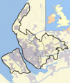 Merseyside
 South Yorkshire
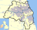 Tyne and Wear
 West Midlands
 West Yorkshire
Média použitá na této stránce
.svg)
(c) Nilfanion and Dr Greg, CC BY-SA 3.0
Map highlighting the metropolitan counties of England from 2009. (Still valid in 2012.)
- metropolitan county
Equirectangular map projection on WGS 84 datum, with N/S stretched 170%
Geographic limits:
- West: 6.75W
- East: 2.0E
- North: 56.0N
- South: 49.75N

Map of en:West Yorkshire and surrounding area, with indented map of the British Isles for national context.
County and borough boundaries in black, urban areas in grey, motorways in blue with white stripe, water bodies in light blue.
Map of Tyne and Wear for use in infoboxes. Urban areas are shown in Grey, bodies of water in light blue, motorways in deep blue (with white stripe), county and borough boundaries are in black.

Map of the West Midlands county; urban areas are in grey, county and borough boundaries in black, water in light-blue, motorways in deep-blue with white stripe. Includes mini-map of the United Kingdom, with the West Midland's position for context.

Map of en:South Yorkshire and surrounding area, with micromap of the British Isles for context. Urban areas are shown in grey, water bodies in light-blue, motorways in blue with white stripe and county and borough boundaries in black.

A map of the metropolitan county of Greater Manchester, in North West England. Appended to the bottom left is a mini map of the British Isles with Greater Manchester's location and relative size marked in red. On the main map rural areas are in yellow; urban areas are in grey; district and county boundaries are in black; bodies of water are in light blue; motorways are in dark blue with a white stripe.

Map of Merseyside, England