Annapolis
| Annapolis | |
|---|---|
 Centrum města | |
 vlajka | |
| Poloha | |
| Souřadnice | 38°58′43″ s. š., 76°29′31″ z. d. |
| Nadmořská výška | 12 m n. m. |
| Časové pásmo | UTC−05:00 (standardní čas) UTC−04:00 (letní čas) Eastern Time Zone |
| Stát | |
| Federální stát | Maryland |
| Okres | Anne Arundel County |
 Annapolis | |
| Rozloha a obyvatelstvo | |
| Rozloha | 21,0 km² |
| Počet obyvatel | 40 812 (2020)[1][2] |
| Hustota zalidnění | 1 944,2 obyv./km² |
| Správa | |
| Starosta | Gavin Buckley (od 2017) |
| Vznik | 1649 |
| Oficiální web | www |
| Telefonní předvolba | 410 a 443 |
| PSČ | 21401, 21402, 21403, 21404, 21405, 21409, 21411 a 21412 |
| Některá data mohou pocházet z datové položky. | |
Annapolis je hlavní město státu Maryland ve Spojených státech amerických a sídlo okresu Anne Arundel County, ležící na břehu zátoky Chesapeake u ústí řeky Severn asi 50 km východně od Washingtonu a 40 km jižně od Baltimoru. Rozkládá se na celkové ploše 19,7 km² a žije zde přibližně 40 tisíc obyvatel (k roku 2020).
Annapolis má přezdívku „plachtařská“ nebo „rejdařská metropole“ díky vhodným podmínkám k provozování těchto aktivit.[3] V přístavu je možno zahlédnout množství soukromých plachetnicí a jachet. V důsledku klimatické změny a zvýšení hladiny světového oceánu dochází ve městě k čím dál častějším záplavám.[4]
Nachází se zde Námořní akademie Spojených států amerických a univerzita St. John's College. V roce 2007 se zde konala Mírová konference Annapolis, jejímž hlavním cílem bylo obnovení izraelsko-palestinských mírových rozhovorů.[5]
Historie
Annapolis byl osídlen roku 1649 virginskými puritány. Roku 1694 se stal koloniálním hlavním městem Marylandu a o rok později byl přejmenován z Anne Arundel Town na Annapolis na počest budoucí britské královny Anny Stuartovny.[6]
V roce 1774 byl zde podobně jako Bostonu uspořádán místními vlastenci čajový dýchánek jako protest proti Britskému impériu. Od listopadu 1783 do srpna 1784 ve zdejším Maryland State House zasedal Kongres Konfederace, takže Annapolis bylo de facto hlavním městem USA.[7] V roce 1783 zde před ním rezignoval George Washington na funkci vrchního velitele kontinentální armády.[8]
Město se vyhnulo bojům ve válce za nezávislost, v britsko-americké válce roku 1812 i v americké občanské válce, díky čemuž mu zůstalo zachovalé historické jádro. Přesto zde bylo ošetřováno mnoho raněných.
Demografie
Podle sčítání lidu z roku 2020 žilo v Annapolisu 40 812 obyvatel, o 6,3 % více než v roce 2010.[9] Díky vysoké životní úrovni, nízké kriminalitě a příjemnému prostředí počet obyvatel ve městě stabilně stoupá již mnoho dekád.
Rasové složení
I přes svůj maloměstský ráz je Annapolis etnicky velmi rozmanitým městem, což reflektuje pestrost obyvatelstva celého Marylandu.
- 60,1% Bílí Američané
- 26,0% Afroameričané
- 0,3% Američtí indiáni
- 2,1% Asijští Američané
- 0,0% Pacifičtí ostrované
- 9,0% Jiná rasa
- 2,6% Dvě nebo více ras
Obyvatelé hispánského nebo latinskoamerického původu, bez ohledu na rasu, tvořili 22,9% populace.[10]
Charakter města
Annapolis je oblíbeným letoviskem pro milovníky plachtění, v místních docích se nachází i množství luxusních jachet či motorových člunů. Zachovalé historické centrum města je charakterizováno živými koloniálními ulicemi s restauracemi, které nabízejí místní speciality, zejména pak krabí koláčky.[11] Nachází se zde rovněž Maryland State House, sídlo vlády a guvernéra státu, či episkopální kostel svaté Anny.
Život ve městě je značně ovlivněn rozsáhlou Námořní akademií Spojených států amerických, jež zaměstnává přibližně 2 500 lidí a kterou navštěvuje více než 4 000 studentů.[12] Vysoká koncentrace mladých lidí přispívá k pověsti Annapolisu coby živého města.
Osobnosti spojené s městem
- James M. Cain, spisovatel
- Robert Duvall, herec
- Travis Pastrana, automobilový závodník
- Leo Strauss, filosof
- Stan Stearns, fotograf
Partnerská města
 Tallinn, Estonsko
 Newport, Wales, Velká Británie
- Dumfries, Skotsko, Velká Británie
 Wexford, Irsko
 Annapolis Royal, Nové Skotsko, Kanada
 Karlskrona, Švédsko
 Redwood City, Kalifornie, USA
Fotogalerie
 Satelitní snímek
 Ulice v Annapolis
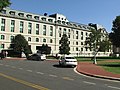 Námořní akademie v Annapolis
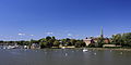 Přistav v Annapolisu
 Maryland State House
Odkazy
Reference
- ↑ Annapolis city, Maryland. United States Census Bureau. Dostupné online. [cit. 2023-03-28].
- ↑ QuickFacts. United States Census Bureau. Dostupné online. [cit. 2023-03-28].
- ↑ Boating & Sailing. VisitMaryland.org [online]. [cit. 2025-02-01]. Dostupné online. (anglicky)
- ↑ ‘Worse and worse and worse:’ Downtown Annapolis now seeing flooding about every 3 days. WTOP News [online]. 2024-08-15 [cit. 2025-02-01]. Dostupné online. (anglicky)
- ↑ ČT24. Mírová konference v Annapolis ještě ani nezačala, už rozděluje Blízký východ. ct24.ceskatelevize.cz [online]. [cit. 2025-02-01]. Dostupné online.
- ↑ Maryland | History, Flag, Map, Capital, Population, & Facts | Britannica. www.britannica.com [online]. 2025-01-31 [cit. 2025-02-01]. Dostupné online. (anglicky)
- ↑ When was Annapolis the capital of the US?. Grateful American® Foundation [online]. 2015-11-08 [cit. 2025-02-01]. Dostupné online. (anglicky)
- ↑ Malá metropole, kterou kráčely velké dějiny. Přístav Annapolis pamatuje George Washingtona i otrokářské lodě. Radiožurnál [online]. 2024-05-21 [cit. 2025-02-01]. Dostupné online.
- ↑ United States Census Bureau, sčítání z roku 2010 [online]. American FactFinder. Dostupné online.
- ↑ JOURNAL, Statesman. Annapolis city, Maryland Demographics and Housing 2020 Decennial Census. Statesman Journal [online]. [cit. 2025-02-01]. Dostupné online. (anglicky)
- ↑ THE 10 BEST Crabcakes in Annapolis | Naptown Scoop. www.naptownscoop.com [online]. [cit. 2025-02-01]. Dostupné online.
- ↑ United States Naval Academy | Data USA. datausa.io [online]. [cit. 2025-02-01]. Dostupné online. (anglicky)
Externí odkazy
 Obrázky, zvuky či videa k tématu Annapolis na Wikimedia Commons
 - Oficiální stránky (anglicky)
Média použitá na této stránce

Autor: Uwe Dedering, Licence: CC BY-SA 3.0
Location map of the USA (without Hawaii and Alaska).
EquiDistantConicProjection:
Central parallel:
* N: 37.0° N
Central meridian:
* E: 96.0° W
Standard parallels:
* 1: 32.0° N
* 2: 42.0° N
Made with Natural Earth. Free vector and raster map data @ naturalearthdata.com.
Formulas for x and y:
x = 50.0 + 124.03149777329222 * ((1.9694462586094064-({{{2}}}* pi / 180))
      * sin(0.6010514667026994 * ({{{3}}} + 96) * pi / 180))
y = 50.0 + 1.6155950752393982 * 124.03149777329222 * 0.02613325650382181
      - 1.6155950752393982  * 124.03149777329222 *
     (1.3236744353715044  - (1.9694462586094064-({{{2}}}* pi / 180))
      * cos(0.6010514667026994 * ({{{3}}} + 96) * pi / 180))


.svg)

Zelený pruh má znázorňovat většinové katolické obyvatelsto Irska, oranžový pruh reprezentuje protestantskou menšinu a bílý pruh uprostřed znázorňuje mír a harmonii mezi nimi.
.svg)
Flag of Canada introduced in 1965, using Pantone colors. This design replaced the Canadian Red Ensign design.


Autor: David Shapinsky for PINGNews/Shapinsky MultiMedia from Washington, D.C., United States, Licence: CC BY-SA 2.0
US Naval Academy in Annapolis, Maryland. DF Shapinsky for PINGNews.com/Shapinsky MultiMedia.

Flag of Annapolis, Maryland, U.S.
- — Direct source:
- Physical flag obtained directly from City of Annapolis in early June 2020
- — Suggested caption for this image:
- Annapolis's first official flag, adopted in January 1965, is styled after the personal royal badge of Queen Anne after whom the city was named. Resembling the floral badge of Great Britain, a crown hovers over a thistle (representing Scotland) and a rose (representing England), growing from a single stalk to portray their union. The motto Vixi liber et moriar means "I have lived free and will die so".
- — Source for suggested caption:
- (January 12, 1965). "DAR Chapter Presents City With Official Banner". Evening Capital (Vol. LXXXI, No. 9): 1. Image caption: "City's First Flag".
- — Quotation from the Annapolis Evening Capital, January 12, 1965:
- Image caption on page 1 of newspaper: "City's First Flag ... The emblem which the flag depicts was the personal badge of Queen Anne of England, for whom Annapolis was named, which she wore to symbolize the union between England--represented by the rose on the right--and Scotland--represented by the thistle on the left. The red rose is of the House of Lancaster and the white rose of the House of York. The hovering crown further emphasizes unity. At the flag's base is the motto, "Vixi liber et moriar" ("I have lived free and will die so").
Autor: Flickr user: high limitzz https://www.flickr.com/people/highlimitstudio/, Licence: CC BY 2.0
annapolis, boutiques, restaurants and cafes are located. the weather was crappy Location: Annapolis

Autor: Martin Falbisoner, Licence: CC BY-SA 3.0
Maryland State House as seen from College Ave

Autor: Martin Falbisoner, Licence: CC BY-SA 3.0
Annapolis, MD, Acton Cove: Yachts and St. Mary's Church

Autor: http://www.terraprints.com, Licence: CC BY 2.5
The raw satellite imagery shown in these images was obtain from NASA and/or the US Geological Survey. Post-processing and production by www.terraprints.com