Afrodisias
| Afrodisias | |
|---|---|
 | |
| Poloha | |
| Souřadnice | 37°42′30″ s. š., 28°43′25″ v. d. |
| Stát | |
 Afrodisias | |
| Rozloha a obyvatelstvo | |
| Rozloha | 0,7 km² |
| Správa | |
| Oficiální web | www |
| Některá data mohou pocházet z datové položky. | |
Afrodisias, řecky Ἀφροδισιάς, bylo starořecké město v Anatolii (dnešní Turecko), na historickém území Kárie. Město zcela zaniklo, jeho ruiny se nacházejí poblíž dnešního města Geyre. Roku 2017 byly ruiny Afrodisia zapsány na seznam Světového dědictví UNESCO.[1] Město bylo nazváno podle řecké bohyně krásy Afrodíty, jejíž velká modla se zde nacházela. Tato modla se dochovala, byť bez tváře. Odborníci spekulují o tom, že původně mohlo jít o místní bohyni plodnosti, která byla s Afroditou teprve později identifikována. V římské epoše se menší sošky Afrodity z Afrodisie staly oblíbeným vývozním artiklem, byly nalezeny všude po římském světě, včetně Pax Julie (dnešní Beja v Portugalsku). Podle byzantské encyklopedie Suda město dříve neslo tři jiná jména: Lelégōn Pólis (Λελέγων πόλις), Megálē Pólis (Μεγάλη Πόλις) a Ninóē (Νινόη). K nejvýznamnějším částečně dochovaným památkám patří Afroditin chrám, propyleje (slavnostní brána) zvané Sebastion, búleutérion (možná též odeon) a stadion.[2] Jsou vystavěny z bílého a modro-šedého mramoru rozsáhle těženého z přilehlých svahů. V době, kdy byla Kárie ovládnuta Římem a stala se římskou provincií, bylo Afrodisias jejím oficiálním hlavním městem. Největší výstavba proběhla právě v římských časech, zejména v éře císaře Augusta (tedy na přelomu letopočtu), prostřednictvím jím osvobozeného otroka Gaia Julia Zoila.[3] Jistě od 2. století (možná dříve) mělo město i svou židovskou komunitu.[4][5] Afrodisias zůstal centrem pohanství i pod byzantskou vládou, až do konce 5. století (Afroditin chrám byl předělán na křesťanskou baziliku, ale ta byla nakonec zrušena císařem Zenonem, protože se v ní prý scházela jeho opozice; někdy mezi lety 481-484).[6][7] Město bylo zničeno zemětřesením na začátku 7. století a nikdy již nebylo obnoveno, pouze v místě divadla bylo vybudováno malé opevněné sídliště, které bylo okolo roku 640 pojmenováno Stauropolis (Σταυρούπολις), tedy "Město kříže", což mělo zahladit stopy pohanské tradice. V 8. století již však ani tento název nebyl znám a pro označení místa užíval se jen název Kárie, tedy jméno celé oblasti (odtud také pochází dnešní turecké jméno nedalekého Geyre). Diecéze zde fungovala až do 11. století. Zbytky Afrodisia byly znovu vypleněny rebelem Theodorem Mankafasem v roce 1188 a poté seldžuckými Turky v roce 1197. Ke konci 13. století se natrvalo dostaly pod tureckou kontrolu. Některé části Geyre byly ve 20. století odstraněny, aby bylo možné odkrýt zbytky starověkého sídla. Nové Geyre začalo být stavěno o kus dál. Ve městě se narodil starořecký filozof Alexandr Afrodisijský (žil ve 2. století př. n. l.) a spisovatel Charitón (2. století), autor nejstaršího plně dochovaného románu Příhody Chairea a Kallirhoy (Τῶν Περὶ Χαιρέαν Καὶ Καλλιρρόην).
Město pro odborníky i veřejnost znovuobjevil turecký fotograf a cestovatel arménského původu Ara Güler v ro ce1958. V jednom z pozdějších rozhovorů uvedl: "Do Geyre mě zavedla náhoda. Nikdy v životě jsem o tom místě neslyšel, a když jsem ho uviděl, nevěřil jsem svým očím. Stály tam skvělé sloupy a překrásné sochy. Některé sloupy podpíraly zdi vesnických domů, které vypadaly, že se každou chvíli zhroutí. Jedno nádherně zdobené víko sarkofágu sloužilo jako žlab, zatímco na jiném hráli vesničané karty. Nikdy jsem neviděl tak zajímavé místo. Rychle jsem běžel pro svůj fotoaparát a udělal jsem celou řadu fotografií."[8] Fotografie zaslal do francouzského časopisu Horizon a brzy byl požádán o další, tentokrát ale i s komentářem. Ten napsal profesor klasické archeologie Kenan Erim. Díky finanční podpoře společnosti National Geographic Society mohl tento archeolog tureckého původu pracující na Newyorské univerzitě začít na počátku 60. let 20. stol. s archeologickými vykopávkami[8].
Galerie
 Afroditin chrám
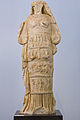 Modla Afrodity
 Tetrapylon
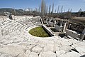
 (c) Carlos Delgado, CC BY-SA 3.0Sebastion
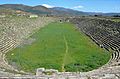 Stadion
 Římské divadlo
 Římské lázně
 Jižní agora
 Reliéf zobrazující zrození Afrodity
 Sarkofágy
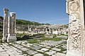 Vstup do divadla
Odkazy
Externí odkazy
 Obrázky, zvuky či videa k tématu Afrodisias na Wikimedia Commons
Reference
V tomto článku byl použit překlad textu z článku Aphrodisias na anglické Wikipedii.
- ↑ Aphrodisias. UNESCO World Heritage Centre [online]. [cit. 2023-04-23]. Dostupné online. (anglicky)
- ↑ WELCH, Katherine. The Stadium at Aphrodisias. American Journal of Archaeology. 1998, roč. 102, čís. 3, s. 547–569. Dostupné online [cit. 2023-04-23]. ISSN 0002-9114. doi:10.2307/506401.
- ↑ REYNOLDS, Joyce Maire. Aphrodisias and Rome: Documents from the Excavation of the Theatre at Aphrodisias Conducted by Professor Kenan T. Erim, Together with Some Related Texts. [s.l.]: Society for the Promotion of Roman Studies 276 s. Dostupné online. ISBN 978-0-907764-00-7. (anglicky) Google-Books-ID: ME5uAAAAMAAJ.
- ↑ REYNOLDS, J.; TANNENBAUM, R. F. Jews and Godfearers at Aphrodisias: Greek Inscriptions with Commentary. [s.l.]: Cambridge Philological Society 1 s. Dostupné online. ISBN 978-1-913701-18-5. (anglicky) Google-Books-ID: LbYzEAAAQBAJ.
- ↑ BONZ, Marianne Palmer. The Jewish Donor Inscriptions from Aphrodisias: Are They Both Third-Century, and Who Are the Theosebeis?. Harvard Studies in Classical Philology. 1994, roč. 96, s. 281–299. Dostupné online [cit. 2023-04-23]. ISSN 0073-0688. doi:10.2307/311328.
- ↑ ROUECHÉ, Charlotte; REYNOLDS, Joyce Maire. Aphrodisias in Late Antiquity: The Late Roman and Byzantine Inscriptions Including Texts from the Excavations at Aphrodisias Conducted by Kenan T. Erim. [s.l.]: Society for the Promotion of Roman Studies 456 s. Dostupné online. ISBN 978-0-907764-09-0. (anglicky) Google-Books-ID: B4oaAAAAYAAJ.
- ↑ CORMACK, Robin. Byzantine Aphrodisias. Changing the Symbolic Map of a City. Proceedings of the Cambridge Philological Society. 1990, čís. 36 (216), s. 26–41. Dostupné online [cit. 2023-04-23]. ISSN 0068-6735.
- ↑ a b KRASLOVÁ, Radvana. Afrodisias - kráska z údolí Dandalaz. Země světa. 3.1.2024, roč. 23, čís. 1, s. 44–49. Dostupné online.
Média použitá na této stránce


.jpg)
Autor: Carole Raddato from FRANKFURT, Germany, Licence: CC BY-SA 2.0
According to its inscription it was dedicated to Aphrodite and the people of the city by Gaius Julius Zoilus, a former slave of Octavian. The seating capacity was 8,000.
The cavea is preserved in a good condition: according to the standards of the Hellenistic theatres in Asia Minor, it is bigger than a semi-circle. In the following century, the monumental skene was added, which comprised six vaulted halls used as logeia, arranged around a central room, which led behind the proscenium. The facade of the skene (scaenae frons) was decorated with niches with wonderful sculptures, such as the statue of Domitian, the personification of Demos, two Muses with Apollo or Dionysus, the statue of an athlete, a replica of a statue by Polyclitus and figures of Nikes. During the 2nd century AD, the conversions necessary for the new popular spectacles of animal fights and duels were carried out: the passageways were closed, the orchestra was lowered and the parapets in front of the seats were reinforced, so that the gladiators and the animals could fight without risking the lives of the spectators.%2c_Aphrodisias_Museum%2c_Turkey_(19868596734).jpg)
Autor: Carole Raddato from FRANKFURT, Germany, Licence: CC BY-SA 2.0
Relief depicting the birth of Aphrodite (Aphrodite Anadyomene), Aphrodisias Museum, Turkey

Autor: wneuheisel, Licence: CC BY 2.0
This cult image Aphrodite of Aphrodisias was once housed in the Temple of Aphrodite. She was a distinctive local goddess of fertility who became, by interpretatio graeca, identified with the Greek Aphrodite.
.jpg)
Autor: Carole Raddato from FRANKFURT, Germany, Licence: CC BY-SA 2.0
Located in the north end of the city, the Stadium is probably the best preserved and biggest of its type in Mediterranean. It is 262 m long and 59 m wide with 22 rows of seats. It has the capacity of 30.000 spectators.
The ends of the stadium are slightly convex, giving the whole a form rather suggesting an ellipse. In this way, the spectators seated in this part of the stadium would not block each other's view and would be able to see the whole of the arena.
The stadium was specially designed for athletic contests, but after the theatre was damaged in the 7th century earthquake the eastern end of the arena began to be used for games, circuses, wild beast shows and gladiatorial combats. During the Roman period the stadium was the scene of a large number of athletic competitions and festivals.
Source: www.aphrodisias.com/listingview.php?listingID=9
Autor: Bernard Gagnon, Licence: CC BY-SA 3.0
Baths of Hadrian, Aphrodisias, Turkey

Autor: Dosseman, Licence: CC BY-SA 4.0
Looking from the colonnade to the east of the Theatre Baths we look towards the Tetrastoon proper.
The Tetrastoon, a piazza with four porticos and an altar at the centre, one could get from there to the theatre, which is adjacent. One supposes it was used as a market and shopping street and was built in the fourth century AD when the older agora was permanently flooded because of the rising level of groundwater.
Wiktionary has "A four-sided colonnade, typically enclosing a courtyard" and "From Ancient Greek τετράστῳον (tetrástōion), from neuter of τετράστῳος (tetrástōios, “having four porticoes”) from Ancient Greek τετράς (tetrás, “four”) + στοά (stoá, “portico, colonnade”)"
From the Excavations website I quote: "The marble-paved and colonnaded square in front of the Theatre, known as the Tetrastoon (Four Porticoes), was built in the first or second century AD, but its current form is due to a restoration in the AD 360s by a provincial governor called Antonius Tatianus. The east side of the square became at this time a place of honour for newly erected portrait statues of emperors and governors. Several were set up in the later fourth and fifth centuries. Two of these statues survive, one for Theodosius I or II and one for a governor called Flavius Palmatus. "
Autor: Bernard Gagnon, Licence: CC BY-SA 3.0
Tetrapylon of Aphrodisias, Turkey

Autor: Dosseman, Licence: CC BY-SA 4.0
From a note on site: “The Bouleuterion (Council House) was central to the civic life of Aphrodisias in antiquity. Like a modern town hall, it served as the meeting place of the city’s administrative council (the Boule), and as a multi-purpose indoor theatre, concert hall and assembly space. In form, the Bouleuterion (Council House) is a semi-circular, theatre-like building (originally roofed), with seating for an estimated 1750 persons, and a richly decorated stage. During excavation in the 1960s, eight oversize marble statues were found in the ruins of the stage building. They are now on display in the Aphrodisias Museum. These statues originally stood between the columns of the building’s elaborate two-storied marble façade (facing the auditorium). They included images of gods and personifications associated with the Boule (town council), as well as portraits of leading citizens.


(c) Carlos Delgado, CC BY-SA 3.0
Sebasteion in Aphrodisias, in modern-day Turkey.


Autor: Dosseman, Licence: CC BY-SA 4.0
From a vantage point to the southeast (probably the north top edge of the Theatre cave) we here see the area where now the whole pool has been excavated, most of the agora, and in the left top corner the Hadrian Baths.
On Google Maps a large space is taken up by a 170m-long pool, that is (in June 2020) wrongly identified as the stadium (I have informed Google). The actual stadium is in a more probable position, to the north of town. That the pool is visible on a satellite picture is thanks to “The Mica and Ahmet Ertegün South Agora Pool Project, which began in 2013 with an outstanding promise by Mrs. Ertegün of five years of funding to excavate the pool and to research its complex character, long life, and its functional operation. The excavation, supervised by Professor Andrew Wilson, was completed in August 2017, and brought an abundance of remarkable results and important finds, from Roman to Ottoman times.” (quote from Aphrodisias Excavations). The pictures I took in 2011 show the area around this pool, some of the north and south side, and many of the west side. Some were taken from afar, and show the colonnades around the pool, as well as the Hadrian Baths at the west side of the agora.
I took some pictures in an area to the southwest of the pool, that maybe belonged to a basilica that’s there. GPS makes it possible to identify most locations. At the time of my last visit in 2011 a lot was still waiting further excavations and restoration.