Aristillus (kráter)
| Kráter Aristillus | |
|---|---|
 Aristillus | |
| Souřadnice na Měsíci | |
| Selenografická šířka | 33,9° S [1] |
| Selenografická délka | 1,2° V [1] |
| Další údaje | |
| Typ kráteru | impaktní kráter |
| Průměr kráteru | 54 km [1] |
| Hloubka | 3,6 km |
| Colongitudo | 359° |
| Eponym | Aristillus |
Aristillus je měsíční impaktní kráter nacházející se ve východní části Mare Imbrium (Moře dešťů). Jižně leží menší kráter Autolycus (průměr 39 km) a jihozápadně větší kráter Archimedes (průměr 83 km). Část moře jihozápadně od kráteru se nazývá Sinus Lunicus (Záliv Luny). Kráter Aristillus má průměr 54 kilometrů [1], uprostřed je trojice vrcholků tyčících se do výše cca 900 metrů.[2] Jeho západním okrajovým valem prochází nultý měsíční poledník. Kráter je pojmenován podle řeckého astronoma Aristilla.[2]
Severovýchodně leží kráter Theaetetus, severo-severovýchodně kráter Cassini. Východně začíná jižní okraj pohoří Montes Caucasus (Kavkaz) tvořícího předěl mezi Mare Imbrium a Mare Serenitatis (Moře jasu).
Satelitní krátery


V okolí kráteru se nachází několik sekundárních kráterů.[1] Ty byly označeny podle zavedených zvyklostí jménem hlavního kráteru a velkým písmenem abecedy.
| Aristillus | Sel. šířka | Sel. délka | Průměr |
|---|---|---|---|
| A [3] | 33.6° S | 4.5° V | 4,4 km |
| B [4] | 34.8° S | 1.9° Z | 8 km |
Kráter Aristillus v kultuře
- Kráter Aristillus je zmíněn ve vědeckofantastickém románu britského spisovatele Arthura C. Clarka Měsíční prach.[5]
- Anglická prog rocková kapela Camel pojmenovala svou první píseň na albu Moonmadness podle kráteru Aristillus.[6]
Odkazy
Reference
V tomto článku byl použit překlad textu z článku Aristillus (crater) na anglické Wikipedii.
- ↑ a b c d e Crater Aristillus on Moon Gazetteer of Planetary Nomenclature, IAU, USGS (anglicky)
- ↑ a b RÜKL, Antonín. Atlas Měsíce. Praha: Aventinum, 1991. ISBN 80-85277-10-7. Kapitola Aristillus, s. 50/12.
- ↑ Crater Aristillus A on Moon Gazetteer of Planetary Nomenclature, IAU, USGS (anglicky)
- ↑ Crater Aristillus B on Moon Gazetteer of Planetary Nomenclature, IAU, USGS (anglicky)
- ↑ CLARKE, Arthur Charles. Měsíční prach. Praha: Odeon, 1989. ISBN 80-207-0240-7. Kapitola třetí, s. 23.
- ↑ Moonmadness na AllMusic.com (anglicky)
Literatura
- RÜKL, Antonín. Atlas Měsíce. Praha: Aventinum, 1991. ISBN 80-85277-10-7.
Externí odkazy
 Obrázky, zvuky či videa k tématu Aristillus na Wikimedia Commons
 - Kráter Aristillus Archivováno 23. 9. 2009 na Wayback Machine, Wikispaces.com (anglicky)
- LAC 25, mapa 1:1 000 000 (Lambertova projekce)
Média použitá na této stránce
Autor: Srbauer, Licence: CC BY-SA 3.0
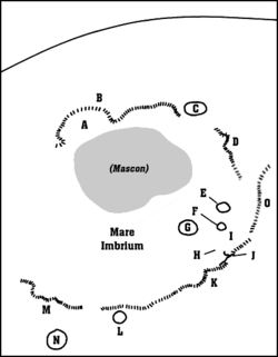
A map of Mare Imbrium.
- A: Sinus Iridum (Regenbogenbucht)
- B: Montes Jura (Jura-Gebirge)
- C: Plato
- D: Montes Alpes (Alpen)
- E: Aristillus
- F: Autolycus
- G: Archimedes
- H: Palus Putretinis (Sumpf der Fäulnis)
- I: Hadley Rille
- J: Apollo 15 landing site
- K: Montes Apenninus (Apenninen)
- L: Erathostenes
- M: Montes Carpatus (Karpaten)
- N: Copernicus
- O: Montes Caucasus (Kaukasus)
Crater Aristillus (detail of LRO - WAC global moon mosaic; Mercator projection)
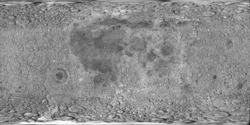
cylindrical map projection of the Moon. The Moon's whole surface was mapped by the Clementine spacecraft in 1994, here North is at the top. The dark floor of crater Plato is at the middle top above Mare Imbrium, while the bright floor and rays of crater Tycho is near the middle bottom below Mare Imbrium. Mare Procellarum is at the near left, and Mare Tranquillitatis is just right of centre and Mare Crisium is at the near right. The far left and far right show the contrast of the mostly cratered farside with small isolated mare.
Autor: M. Gålfalk, G. Olofsson, and H.-G. Florén; SIRCA camera, Licence: CC BY-SA 3.0
The Archimedes crater of the Moon and other features.
Archimedes is the largest crater near the center of the picture. It lies within the Mare Imbrium. The other large craters are Aristillus (to the right of Archimedes and higher, with pronounced central peak) and Autolycus (to the right and lower). At the lower right edge of the picture parts of the Montes Apenninus are visible.
Infrared image in L band centred on 3.75 micrometres. Taken with the SIRCA camera by M. Gålfalk, G. Olofsson, and H.-G. Florén. Nordic Optical Telescope, Stockholm Observatory. More images can be found here


