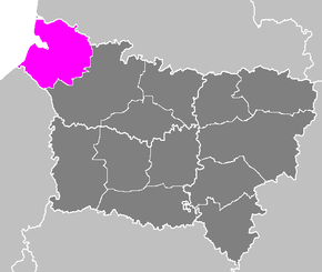
Arrondissement Abbeville
| Arrondissement Abbeville | |
|---|---|
| Geografie | |
| Hlavní město | Abbeville |
| Souřadnice | 50°10′ s. š., 1°45′ v. d. |
| Rozloha | 1 589 km² |
| Geodata (OSM) | OSM, WMF |
| Obyvatelstvo | |
| Počet obyvatel | 134 951 (2012) |
| Hustota zalidnění | 84,9 obyv./km² |
| Správa regionu | |
| Stát | |
| Region | Hauts-de-France |
| Departement | Somme |
| Druh celku | Arrondissement |
| Podřízené celky | Kantony: 7 Obce: 200 |
| Některá data mohou pocházet z datové položky. | |
Arrondissement Abbeville (fr. Arrondissement d'Abbeville) je správní územní jednotka ležící v departementu Somme a regionu Hauts-de-France ve Francii. Člení se dále na 7 kantonů a 200 obcí.
Kantony
od roku 2015:
- Abbeville-1
- Abbeville-2
- Doullens (část)
- Friville-Escarbotin
- Gamaches (část)
- Poix-de-Picardie (část)
- Rue
před rokem 2015:
- Abbeville-Nord
- Abbeville-Sud
- Ailly-le-Haut-Clocher
- Ault
- Crécy-en-Ponthieu
- Friville-Escarbotin
- Gamaches
- Hallencourt
- Moyenneville
- Nouvion
- Oisemont
- Rue
- Saint-Valery-sur-Somme
Externí odkazy
 Obrázky, zvuky či videa k tématu Arrondissement Abbeville na Wikimedia Commons
Média použitá na této stránce
Autor: Patricia.fidi, Licence: CC0
"Lion of Flandres appearing", used on the flag of the Belgian Flanders (located partly in the west of Belgium). It is also sometimes used for French Flanders (western department of northern France). Artois and Hainault (adjacent to this area) have different flags, as well as the Nord-Pas-de-Calais)
Maps of arrondissements and cantons of France: Arrondissement d Abbeville.PNG


