Arrondissement Montmorillon
| Arrondissement de Montmorillon | |
|---|---|
 | |
| Geografie | |
| Hlavní město | Montmorillon |
| Souřadnice | 46°26′0″ s. š., 0°52′ v. d. |
| Rozloha | 3 000 km² |
| Geodata (OSM) | OSM, WMF |
| Obyvatelstvo | |
| Počet obyvatel | 74 289 (2007) |
| Hustota zalidnění | 24,8 obyv./km² |
| Správa regionu | |
| Stát | |
| Region | Poitou-Charentes |
| Departement | Vienne |
| Druh celku | Arrondissement |
| Podřízené celky | Kantony: 11 Obce: 98 |
| Některá data mohou pocházet z datové položky. | |
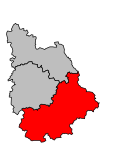
Arrondissement Montmorillon je francouzský arrondissement ležící v departementu Vienne v regionu Poitou-Charentes. Člení se dále na 11 kantonů a 98 obcí.
Kantony
- Availles-Limouzine
- Charroux
- Chauvigny
- Civray
- Couhé
- Gençay
- L'Isle-Jourdain
- Lussac-les-Châteaux
- Montmorillon
- Saint-Savin
- La Trimouille
Externí odkazy
 Obrázky, zvuky či videa k tématu Arrondissement Montmorillon na Wikimedia Commons
Média použitá na této stránce
Autor: Michiel1972, Licence: CC BY-SA 3.0
Location of the arrondissement Montmorillon within its departement.
Autor: Patricia.fidi, Licence: CC0
Flag of the region Poitou-Charentes in France.
Autor: Patricia Fidi, Licence: CC0
Regional flag of the french province Aquitaine


