Arrondissement Namur
| Okres Namur Arrondissement de Namur | |
 most přes Mázu ve městě Namur | |
| Geografie | |
|---|---|
| Hlavní město | Namur |
| Status | arrondissement |
| Souřadnice | 50°30′ s. š., 4°54′ v. d. |
| Rozloha | 1 164,85 km² |
| Časové pásmo | +1 |
| Obyvatelstvo | |
| Počet obyvatel | 110 335 (2017) |
| Hustota zalidnění | 94,7 obyv./km² |
| Správa regionu | |
| Nadřazený celek | Namur |
| Druh celku | provincie |
| Podřízené celky | 16 obcí |
| Sídlo | Namur |
| Některá data mohou pocházet z datové položky. | |
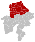
Arrondissement Namur (francouzsky: Arrondissement de Namur; nizozemsky: Arrondissement Namen) je jeden ze tří arrondissementů (okresů) v provincii Namur v Belgii.
Jedná se o politický a zároveň soudní okres.
Obyvatelstvo
Počet obyvatel k 1. lednu 2017 činil 110 335 obyvatel. Rozloha okresu činí 1 164,85 km².
Obce
Okres Namur sestává z těchto obcí:
- Andenne
- Assesse
- Éghezée
- Fernelmont
- Floreffe
- Fosses-la-Ville
- Gembloux
- Gesves
- Jemeppe-sur-Sambre
- La Bruyère
- Mettet
- Namur
- Ohey
- Profondeville
- Sambreville
- Sombreffe
Reference
V tomto článku byl použit překlad textu z článku Arrondissement of Namur na anglické Wikipedii.
Média použitá na této stránce
This is the national flag of Belgium, according to the Official Guide to Belgian Protocol. It has a 13:15 aspect ratio, though it is rarely seen in this ratio.
Its colours are defined as Pantone black, Pantone yellow 115, and Pantone red 032; also given as CMYK 0,0,0,100; 0,8.5,79,0; and 0,94,87,0.Map of Namur District in province of Namur, Belgium.
Autor: Jean-Pol GRANDMONT, Licence: CC BY 3.0
Namur (Belgium), the Meuse river, the Jambes' bridge and the citadel.
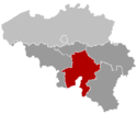
Location of the province Namur (Belgium).


