Arrondissement Nivelles
| Okres Nivelles Arrondissement de Nivelles | |
 pohled na město Nivelles | |
| Geografie | |
|---|---|
| Hlavní město | Nivelles |
| Status | arrondissement |
| Souřadnice | 50°40′12″ s. š., 4°34′48″ v. d. |
| Rozloha | 1 090,56 km² |
| Časové pásmo | +1 |
| Geodata (OSM) | OSM, WMF |
| Obyvatelstvo | |
| Počet obyvatel | 399 123 (2017) |
| Hustota zalidnění | 366 obyv./km² |
| Správa regionu | |
| Nadřazený celek | Valonský Brabant |
| Druh celku | provincie |
| Podřízené celky | 27 obcí |
| Sídlo | Nivelles |
| Některá data mohou pocházet z datové položky. | |
Arrondissement Nivelles (francouzsky: Arrondissement de Nivelles; nizozemsky: Arrondissement Nijvel) je jediný arrondissement (okres) v provincii Valonský Brabant v Belgii.
Jedná se o politický a zároveň soudní okres.
Historie
Před rokem 1995 byl okres Nivelles součástí provincie Brabant
Obyvatelstvo
Počet obyvatel k 1. lednu 2017 činil 399 123 obyvatel. Rozloha okresu činí 1 090,56 km².
Obce
Okres Nivelles sestává z těchto obcí:
- Beauvechain
- Braine-l’Alleud
- Braine-le-Château
- Chastre
- Chaumont-Gistoux
- Court-Saint-Etienne
- Genappe
- Grez-Doiceau
- Hélécine
- Incourt
- Ittre
- Jodoigne
- La Hulpe
- Lasne
- Mont-Saint-Guibert
- Nivelles
- Orp-Jauche
- Ottignies-Louvain-la-Neuve
- Perwez
- Ramillies
- Rebecq
- Rixensart
- Tubize
- Villers-la-Ville
- Walhain
- Waterloo
- Wavre
Reference
V tomto článku byl použit překlad textu z článku Arrondissement of Nivelles na anglické Wikipedii.
Média použitá na této stránce
This is the national flag of Belgium, according to the Official Guide to Belgian Protocol. It has a 13:15 aspect ratio, though it is rarely seen in this ratio.
Its colours are defined as Pantone black, Pantone yellow 115, and Pantone red 032; also given as CMYK 0,0,0,100; 0,8.5,79,0; and 0,94,87,0.Autor: Morwen, Licence: CC-BY-SA-3.0
map made by w:en:User:Morwen put under the GNU Free Documentation License.
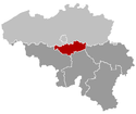
This map indicates (in red) the location of administrative and judicial arrondissements of Nivelles in the province of Brabant Wallon, Belgium. Both maps are the same and fill all the province of Brabant Wallon. In this case, a redirection is available at File:Judicial_Arrondissement_Nivelles_Belgium_Map.png for an easy and intuitive access to judicial arrondissement map. Colors changed based on work from w:nl:Gebruiker:LennartBolks/kaartenhoekje also in PD
Autor: Ligne11, Licence: CC BY-SA 3.0
Panoramic view of the city of Nivelles, Belgium


