Arrondissement Rochefort
| Arrondissement de Rochefort | |
|---|---|
| Geografie | |
| Hlavní město | Rochefort |
| Souřadnice | 45°56′ s. š., 0°58′ z. d. |
| Rozloha | 1 528 km² |
| Geodata (OSM) | OSM, WMF |
| Obyvatelstvo | |
| Počet obyvatel | 178 676 (2007) |
| Hustota zalidnění | 116,9 obyv./km² |
| Správa regionu | |
| Stát | |
| Region | Poitou-Charentes |
| Departement | Charente-Maritime |
| Druh celku | Arrondissement |
| Podřízené celky | Kantony: 13 Obce: 79 |
| Některá data mohou pocházet z datové položky. | |
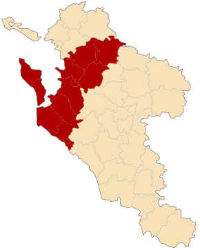
Arrondissement de Rochefort je francouzský arrondissement ležící v departementu Charente-Maritime v regionu Poitou-Charentes. Člení se dále na 13 kantonů a 79 obcí.
Kantony
- Aigrefeuille-d’Aunis
- Le Château-d’Oléron
- Marennes
- Rochefort-Centre
- Rochefort-Nord
- Rochefort-Sud
- Royan-Est
- Royan-Ouest
- Saint-Agnant
- Saint-Pierre-d’Oléron
- Surgères
- Tonnay-Charente
- La Tremblade
Média použitá na této stránce
Autor: Patricia Fidi, Licence: CC0
Regional flag of the french province Aquitaine
Autor: Droop - fr:Droop, Licence: CC BY 3.0
Géolocalisation de l'arrondissement de Rochefort en Charente-Maritime (France).
Autor: Patricia.fidi, Licence: CC0
Flag of the region Poitou-Charentes in France.


