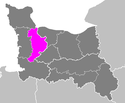
Arrondissement Saint-Lô
| Arrondissement Saint-Lô | |
|---|---|
| Geografie | |
| Hlavní město | Saint-Lô |
| Souřadnice | 49°6′47″ s. š., 1°5′42″ z. d. |
| Rozloha | 1 235 km² |
| Geodata (OSM) | OSM, WMF |
| Obyvatelstvo | |
| Počet obyvatel | 99 117 (2007) |
| Hustota zalidnění | 80,3 obyv./km² |
| Správa regionu | |
| Stát | |
| Region | Normandie |
| Departement | Manche |
| Druh celku | Arrondissement |
| Podřízené celky | Kantony: Obce: |
| Některá data mohou pocházet z datové položky. | |
Arrondissement Saint-Lô je francouzský arrondissement ležící v departementu Manche v regionu Normandie.
Kantony
- Agon-Coutainville (část)
- Carentan (část)
- Condé-sur-Vire
- Pont-Hébert
- Saint-Lô-1 (část)
- Saint-Lô-2
- Villedieu-les-Poêles (část)
Média použitá na této stránce
Flag of Normandie.svg
Flag of Normandy
Flag of Normandy
Arrondissement de Saint-Lô.PNG
Maps of arrondissements and cantons of France: Arrondissement de Saint-Lô.PNG
Maps of arrondissements and cantons of France: Arrondissement de Saint-Lô.PNG


