Arrondissement Turnhout
| Okres Turnhout Arrondissement Turnhout | |
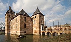
 zámek vévodů z Brabantu v Turnhoutu | |
| Geografie | |
|---|---|
| Hlavní město | Turnhout |
| Status | arrondissement |
| Souřadnice | 51°19′12″ s. š., 4°55′12″ v. d. |
| Rozloha | 1 356,86 km² |
| Časové pásmo | +1 |
| Obyvatelstvo | |
| Počet obyvatel | 455 677 (2017) |
| Hustota zalidnění | 335,8 obyv./km² |
| Správa regionu | |
| Nadřazený celek | Antverpy |
| Druh celku | provincie |
| Podřízené celky | 27 obcí |
| Sídlo | Turnhout |
| Některá data mohou pocházet z datové položky. | |
Arrondissement Turnhout (nizozemsky Arrondissement Turnhout, francouzsky Arrondissement de Turnhout) je jeden ze tří arrondissementů (okresů) v provincii Antverpy v Belgii.
Jedná se o politický a zároveň soudní okres.
Obyvatelstvo
Počet obyvatel k 1. lednu 2017 činil 455 677 obyvatel. Rozloha okresu činí 1 356,86 km².
Obce
Okres Turnhout sestává z těchto obcí:
|
|
Reference
V tomto článku byl použit překlad textu z článku Arrondissement of Turnhout na anglické Wikipedii.
Média použitá na této stránce
This is the national flag of Belgium, according to the Official Guide to Belgian Protocol. It has a 13:15 aspect ratio, though it is rarely seen in this ratio.
Its colours are defined as Pantone black, Pantone yellow 115, and Pantone red 032; also given as CMYK 0,0,0,100; 0,8.5,79,0; and 0,94,87,0.Autor: Ricardo Liberato, Licence: CC BY-SA 2.0
Castle of Turnhout
Autor: w:nl:Gebruiker:Westermarck, Licence: CC BY-SA 3.0
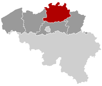
This map indicates (in red) the location of administrative and judicial arrondissements of Turnhout in the province of Antwerp, Belgium. Both maps are the same and fill all the province of Antwerp. In this case, a redirection is available at File:Judicial_Arrondissement_Turnhout_Belgium_Map.png for an easy and intuitive access to judicial arrondissement map.


