Ashland (Kentucky)
| Ashland | |
|---|---|
 | |
| Poloha | |
| Souřadnice | 38°27′50″ s. š., 82°38′30″ z. d. |
| Nadmořská výška | 168 m n. m. |
| Stát | |
 Ashland | |
| Rozloha a obyvatelstvo | |
| Rozloha | 27,9 km² |
| Počet obyvatel | 21 684 (2010)[1] |
| Hustota zalidnění | 777,3 obyv./km² |
| Správa | |
| Vznik | 1786 |
| Oficiální web | www |
| Telefonní předvolba | 606 |
| PSČ | 41101, 41102, 41105 |
| Některá data mohou pocházet z datové položky. | |
Ashland je město ve státě Kentucky ve Spojených státech amerických, druhé největší sídlo okresu Boyd County. V roce 2010 zde žilo 21 684 obyvatel.[2]
Město je lokálním ekonomickým a medicinským střediskem severozápadního Kentucky; nacházejí se zde ocelárny AK Steel a nemocnice King's Daughters Medical Center, která je s počtem zaměstnanců přes 4000 největším zaměstnavatelem ve městě.
Osobnosti města
- Trace Cyrus, hudebník
- Lynndie Englandová, americká vojačka, odsouzená za mučení zajatců ve irácké věznici Abú Ghrajb
- Gina Haspelová, ředitelka CIA
- Jillian Hall, wrestlerka
Galerie
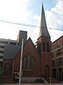
První kostel v Ashlandu
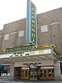
Paramount Arts Center, historické divadlo
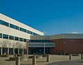
Ashland Community and Technical College

Mosty Ben Williamson Memorial Bridge a Simeon Willis Memorial Bridge
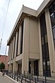
Carl Perkins Federal Building
Odkazy
Reference
- ↑ Sčítání obyvatel Spojených států amerických v roce 2010. Dostupné online. [cit. 2020-07-09]
- ↑ Archivovaná kopie. factfinder.census.gov [online]. [cit. 2018-07-06]. Dostupné v archivu pořízeném dne 2016-10-19.
Externí odkazy
 Obrázky, zvuky či videa k tématu Ashland na Wikimedia Commons
 - (anglicky) Oficiální stránky
Média použitá na této stránce

Autor: Uwe Dedering, Licence: CC BY-SA 3.0
Location map of the USA (without Hawaii and Alaska).
EquiDistantConicProjection:
Central parallel:
* N: 37.0° N
Central meridian:
* E: 96.0° W
Standard parallels:
* 1: 32.0° N
* 2: 42.0° N
Made with Natural Earth. Free vector and raster map data @ naturalearthdata.com.
Formulas for x and y:
x = 50.0 + 124.03149777329222 * ((1.9694462586094064-({{{2}}}* pi / 180))
      * sin(0.6010514667026994 * ({{{3}}} + 96) * pi / 180))
y = 50.0 + 1.6155950752393982 * 124.03149777329222 * 0.02613325650382181
      - 1.6155950752393982  * 124.03149777329222 *
     (1.3236744353715044  - (1.9694462586094064-({{{2}}}* pi / 180))
      * cos(0.6010514667026994 * ({{{3}}} + 96) * pi / 180))


Autor: Youngamerican, Licence: CC BY-SA 3.0
The Paramount Arts Center in Ashland, Kentucky.

(c) Seicer na projektu Wikipedie v jazyce angličtina, CC BY-SA 3.0
en:Ashland Community and Technical College's main entrance.

Autor: Artistic Pursuits (Robert Strovers) from Near Pittsburgh, United States, Licence: CC BY 2.0
Simeon Willis and Ben Williamson Memorial Bridges spanning the Ohio River and linking Ohio to Kentucky.

Front of the First Christian Church of Ashland, located at 315 Seventeenth Street in Ashland, Kentucky, United States. Built in 1890, it is listed on the National Register of Historic Places, and it is part of a Register-listed historic district, the Ashland Commercial Historic District.

Front of the Carl Perkins Federal Building, located at 1405 Greenup Avenue (U.S. Routes 23/60) in Ashland, Kentucky, United States. It was built in 1984.