Astrachaňský chanát
| Astrachaňský chanát Xacitarxan Xanlığı Хаҗитархан Ханлыгы
| |||||||||||||
Geografie
| |||||||||||||
| Obyvatelstvo | |||||||||||||
Národnostní složení | |||||||||||||
| Státní útvar | |||||||||||||
Vznik | |||||||||||||
Zánik | |||||||||||||
| Státní útvary a území | |||||||||||||
| |||||||||||||
Astrachaňský chanát byl tatarský feudální stát, který vznikl po rozpadu Zlaté hordy. Existoval v 15. a 16. století. Hlavním městem byla Astrachaň (Xacitarxan). Zanikl roku 1556, kdy byl připojen k carskému Rusku.[1]
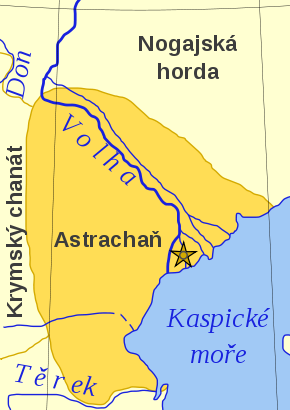
Astrachaňský chanát se nacházel při ústí řeky Volhy do Kaspického moře. Pod jeho kontrolu spadalo území, dnes známé jako Astrachaňská oblast, dále též Kalmycko. Na severu sousedil s Nogajskou hordou a na západě s chanátem Krymským.
Obyvatelstvo bylo tvořeno Nogajci a astrachaňskými Tatary. Vládu nad chanátem měl chán.
Dějiny
Období před Astrachaňským chanátem
Od 5. století n. l. byla oblast dolní Volhy osídlena několika různými turkickými kmeny. O pár století později, po mongolské invazi se území dostalo pod kontrolu chanátu Zlatá horda. Astrachaňský chanát byl založen v roce 1460 Maxmudem Astrachaňskym, plně nezávislým se však stal o šest let později (1466) za vlády Qasima I.
Ruské výboje a Astrachaňská anexe
Roku 1530 se Astrachaňský chanát spojil se svými krymskými a nogajskými sousedy v tažení proti Rusku. V roce 1552 byl Kazaňský chanát dobyt Ivanem Hrozným, dva roky poté (1554) se Astrachaň stala ruským vazalem, díky části astrachaňské šlechty sympatizující s Ruskem. Astrachaňský chán Darwish získal útočiště na Krymu, kde získal podporu pro vyhnání Rusů z Astrachaně. Ivan IV. poslal do Astrachaně armádu, vypálil hlavní město a území anektoval.
Seznam vládců
Chánové Astrachaňského chanátu:
- Mäxmüd (1460–1466)
- Qasim I. (1466–1490)
- Ghabdelkarim (1490–1504)
- Qasim II. (1504–1532)
- Aq Kubek (1532–1534)
- Ghabdraxman (1534–1538)
- Darwish Ghali (1537–1538)
- Shayex Xaydar (1538–1541)
- Aq Kubek (1541–1544)
- Yaghmurchi (1544–1554)
- Darwish Ghali (1554–1557)
Odkazy
Reference
V tomto článku byl použit překlad textu z článku Astrakhan Khanate na anglické Wikipedii.
- ↑ Archivovaná kopie. www.astrologos.cz [online]. [cit. 2009-11-19]. Dostupné v archivu pořízeném dne 2007-10-21.
Související články
Externí odkazy
 Obrázky, zvuky či videa k tématu Astrachaňský chanát na Wikimedia Commons
Média použitá na této stránce
Autor:
- Astrakhan_Khanate_map.svg: user:Untifler
- derivative work: Tchoř (talk)
Autor: Лобачев Владимир, Licence: CC BY-SA 3.0
In the Illustrated Chronicle of Ivan the Terrible, there is an image of the banner of Ivan the Terrible in the Kazan campaign — a bifurcated white one with the image of the Savior and an eight-pointed cross above it. According to other sources, the banner was red instead of white. A copy of this banner, which has been restored many times, is still kept in the Kremlin Armoury.
Autor: Dekodrak, Licence: CC BY-SA 4.0
Flag of the Kalmyk Khanate in Kalmykia (today a republic of Russia located directly north of the North Caucasus in Eastern Europe).
Autor: Vorziblix, Licence: CC0
The flag of the Golden Horde, as shown in Angelino Dulcert's 1339 map. A similar flag appears in the later Catalan Atlas (1375), providing corroboration.
See also Early Mongol Flags at crwflags.com:
- One of the charges is a crescent and the other looks like a simplified form of the tamga from the flag of Idel Ural. On different copies of the flag, the crescent has different size; it is often smaller than shown here, sometimes even reduced into a simple oblique stroke and conjoined with the other charge into a si[n]gle symmetrical object; the other charge also sometimes lacks the oblique part [2, 3]. It was obviously difficult to draw the charges always the same way. The cities with this flag which are easy to identify are [2, 7, 8]: Sarai, the capital (spelled Sarra) - there is also a depiction of the ruler, "Jani Beg Lord of Sarai" ("Jambech senyor de Sarra"); Tana, present-day Azov, Russia; and Urgench, Uzbekistan (spelled Organci, with a cedilla under the c; nowadays ruined). This flag is a variant of the flag of "Emperor of Sarai" ("Emperador de Sara") from "Libro del conoscimiento de los reinos" [7] and might be the one that had really existed, considering the similarity of its charges with those from the flag of Idel Ural.
- [2] Enciclopedia universal ilustrada, vol. XXI, Espan~a Madrid: Espasa-Calpe S.A., 1968
- [3] Istorija otkric'a i istraz<ivanja, vol. I: Poc<etak istraz<ivanja; Mladinska knjiga, Ljubljana, 1979; Original title: A History of Discovery and Exploration, vol. I: The Search Begins;(C) 1973 Aldus Books Limited, London
- [7] Libro del Conoscimiento. Viajes medievales, vol. I Madrid: Fundacio'n Jose' Antonio de Castro, 2005 ISBN 84-96452-11-5 (complete edition) ISBN 84-96452-12-3 (vol. I) [e9s50]
- [8] A[p]pendices. (Ibid.)
- Tomislav Todorovic, 21 April 2007


