Atzenbrugg
| Atzenbrugg | |
|---|---|
.JPG) | |
 znak | |
| Poloha | |
| Souřadnice | 48°17′28″ s. š., 15°54′22″ v. d. |
| Nadmořská výška | 186 m n. m. |
| Stát | |
| Spolková země | Dolní Rakousy |
| Okres | Tulln |
 (c) Karte: NordNordWest, Lizenz: Creative Commons by-sa-3.0 de Poloha obce v okrese Tulln | |
 Atzenbrugg | |
| Rozloha a obyvatelstvo | |
| Rozloha | 26,01 km² |
| Počet obyvatel | 2 812 (2016) |
| Hustota zalidnění | 108,1 obyv./km² |
| Správa | |
| Status | městys |
| Starosta | Ferdinand Ziegler (ÖVP) |
| Oficiální web | www |
| gemeinde | |
| PSČ | 3452 |
| Označení vozidel | TU |
| Některá data mohou pocházet z datové položky. | |
Atzenbrugg je městys v Rakousku ve spolkové zemi Dolní Rakousy v okrese Tulln. Žije zde přibližně přibližně 2 900[1] obyvatel.
Geografie
Geografická poloha
Atzenbrugg se nachází ve spolkové zemi Dolní Rakousy v regionu Mostviertel. Rozloha území městyse činí 26,01 km², z nichž 5,4 % je zalesněných.
Části obce
Území městyse Atzenbrugg se skládá z devíti částí (v závorce uveden počet obyvatel k 1. 1. 2015):
- Atzenbrugg (606)
- Ebersdorf (59)
- Heiligeneich (907)
- Hütteldorf (140)
- Moosbierbaum (295)
- Tautendorf (68)
- Trasdorf (589)
- Watzendorf (42)
- Weinzierl (60)
Sousední obce
- na severu: Zwentendorf an der Donau
- na východu: Michelhausen
- na jihu: Würmla
- na západu: Sitzenberg-Reidling
Politika
Obecní zastupitelstvo
Obecní zastupitelstvo se skládá z 21 členů. Od komunálních voleb v roce 2015 zastávají následující strany tyto mandáty:
Starosta
Nynějším starostou městyse Atzenbrugg je Ferdinand Ziegler ze strany ÖVP.
Galerie

Farní kostel v Heiligeneichu

Kostelík v Trasdorfu
Kaple v Tautendorfu

Mausoleum v Heiligeneichu

Kaple v Heiligeneichu

Zámek v Atzenbruggu
Kaple v Moosbierbaumu
Trasdorf
Vlakové nádraží Moosbierbaum-Heiligeneich
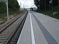
Vlaková stanice Atzenbrugg
Reference
V tomto článku byl použit překlad textu z článku Atzenbrugg na německé Wikipedii.
- ↑ Einwohnerzahl 1.1.2018 nach Gemeinden mit Status, Gebietsstand 1.1.2018. Dostupné online. [cit. 2019-03-09]
Externí odkazy
 Obrázky, zvuky či videa k tématu Atzenbrugg na Wikimedia Commons
 - Oficiální stránky
- (německy) Statistiky
Média použitá na této stránce

Autor: Lencer, Licence: CC BY-SA 3.0
Location map of Austria
Equirectangular projection, N/S stretching 150 %. Geographic limits of the map:
- N: 49.2° N
- S: 46.3° N
- W: 9.4° E
- E: 17.2° E

Autor: Bwag, Licence: CC BY-SA 3.0 at
Ortskapelle von Moosbierbaum, ein Dorf in der niederösterreichischen Marktgemeinde Atzenbrugg.
.JPG)
Autor: Bwag, Licence: CC BY-SA 3.0 at
Schloss Atzenbrugg in der niederösterreichischen Marktgemeinde Atzenbrugg. Im Schloss wohnte und komponierte während einiger sommerlicher Aufenthalte Franz Schubert.

Autor: Bwag, Licence: CC BY-SA 3.0 at
Herz-Jesu-Wegkapelle in Heiligenreich, ein Dorf in der niederösterreichischen Marktgemeinde Atzenbrugg.
(c) Karte: NordNordWest, Lizenz: Creative Commons by-sa-3.0 de
Lage von Atzenbrugg im Bezirk Tulln, Niederösterreich

Autor: Bwag, Licence: CC BY-SA 3.0 at
Katholische Filialkirche hl. Anna in Trasdorf, ein Ortsteil der niederösterreichischen Marktgemeinde Atzenbrugg.

Autor: wdwd, Licence: CC BY 3.0
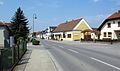
Hauptstrasse in Trasdorf in der Gemeinde Atzenbrugg

Autor: Bwag, Licence: CC BY-SA 3.0 at
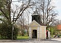
Ortskapelle von Tautendorf, ein Ortsteil der niederösterreichischen Marktgemeinde Atzenbrugg.
Autor: Bwag, Licence: CC BY-SA 3.0 at
Schlossgarten und Schloss Atzenbrugg in der niederösterreichischen Marktgemeinde Atzenbrugg. Im Schloss wohnte und komponierte während einiger sommerlicher Aufenthalte Franz Schubert.

Autor: Haeferl, Licence: CC BY-SA 3.0
Das Mausoleum befindet sich (nach Erweiterung) in der Mitte des Friedhofs.

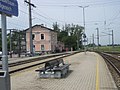
Atzenbrugg train station in Lower Austria

train station Moosbierbaum-Heiligeneich in Lower Austria
Coat of arms of Atzenbrugg, Lower Austria
.JPG)
Autor: Bwag, Licence: CC BY-SA 3.0 at
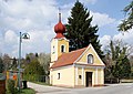
Kath. Pfarrkirche hl. Philipp und Jakob in Heiligeneich, ein Dorf in der niederösterreichischen Marktgemeinde Atzenbrugg.