Auwers (kráter)
| Kráter Auwers | |
|---|---|
 | |
| Souřadnice na Měsíci | |
| Selenografická šířka | 15,1° S |
| Selenografická délka | 17,2° V |
| Další údaje | |
| Průměr kráteru | 20 km [1] |
| Hloubka | 1,7 km |
| Colongitudo | 343° |
| Eponym | Arthur von Auwers |

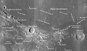
Auwers je starý lunární kráter nacházející se v oblasti pohoří Montes Haemus jižně od Mare Serenitatis (Moře jasu) na přivrácené straně Měsíce. Má průměr 20 km, pojmenován je podle německého astronoma Arthura von Auwerse.[1][2] Má tmavé dno vyplněné zatuhlou lávou a rozrušený okrajový val, který je otevřený na severu.[1]
Severozápadně leží kráter Menelaus, severovýchodně Tacquet, jižně záliv Sinus Honoris (Záliv cti).
Satelitní krátery
V okolí kráteru se nachází několik menších kráterů. Ty byly označeny podle zavedených zvyklostí jménem hlavního kráteru a velkým písmenem abecedy.
| Auwers | Sel. šířka | Sel. délka | Průměr |
|---|---|---|---|
| A | 13,8° S | 18,3° V | 8 km |
Odkazy
Reference
- ↑ a b c Antonín Rükl: Atlas Měsíce, druhé české vydání, Aventinum (Praha 2012), kapitola Bessel, str. 74, č. mapového listu 24, ISBN 978-80-7151-269-1
- ↑ Crater Auwers on Moon Gazetteer of Planetary Nomenclature, IAU, USGS, NASA (anglicky)
Literatura
- RÜKL, Antonín. Atlas Měsíce. 2. vyd. Praha: Aventinum, 2012. ISBN 978-80-7151-269-1.
Externí odkazy
 Obrázky, zvuky či videa k tématu Auwers na Wikimedia Commons
 - Kráter Auwers Archivováno 30. 5. 2018 na Wayback Machine., Moon-Wikispaces.com (anglicky)
- LAC 60, mapa 1:1 000 000 (Mercatorovo zobrazení)
Média použitá na této stránce
Auwers crater
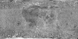
cylindrical map projection of the Moon. The Moon's whole surface was mapped by the Clementine spacecraft in 1994, here North is at the top. The dark floor of crater Plato is at the middle top above Mare Imbrium, while the bright floor and rays of crater Tycho is near the middle bottom below Mare Imbrium. Mare Procellarum is at the near left, and Mare Tranquillitatis is just right of centre and Mare Crisium is at the near right. The far left and far right show the contrast of the mostly cratered farside with small isolated mare.
Montes Haemus with craters Sulpicius Gallus, Menalus and Plinius (detail of LROC - WAC global moon mosaic)


