Badain Jaran
| poušť Badain Jaran - písečné věže a jezera | |
|---|---|
| Světové dědictví UNESCO | |
 | |
| Smluvní stát | |
| Typ | přírodní dědictví |
| Kritérium | vii, viii |
| Odkaz | 1638 (anglicky) |
| Zařazení do seznamu | |
| Zařazení | 2024 (neznámé zasedání) |
Badain Jaran je poušť v severní Číně, v autonomní oblasti Vnitřní Mongolsko a provincii Kan-su. Její rozloha je přibližně 49 000 km², od roku 2024 je část pouště (7262 km²) součástí světového přírodního dědictví UNESCO.
Popis
Nachází se na náhorní plošině Alxa v nadmořské výšce od 1200 m n. m. do 1500 m n. m., je dílčí součástí pouště Gobi. Tato poušť má jedny z největších stacionárních písečných dun na světě - některé z nich dosahují výšky přes 450 metrů.[1] Mezi těmito dunami je více než sto čtyřicet jezer, z nichž některá jsou sladkovodní, některá extrémně slaná. Jsou napájena podzemní vodou a příležitostnými atmosférickými srážkami (i sněhovými).[2] Jezera, která se často nachází v jižní části pouště, dávají poušti její mongolské jméno Badain Jaran, což znamená „tajemná jezera“.
Fotogalerie
 satelitní snímek pouště
 lokalizace pouště
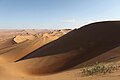 písečné duny
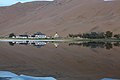 chrám Badain Jaran
Odkazy
Reference
- ↑ Booming Dunes of Badain Jaran Desert [online]. www.atlasobscura.com [cit. 2025-02-22]. Dostupné online. (anglicky)
- ↑ Lakes in Badain Jaran Desert [online]. Program Copernicus [cit. 2025-02-22]. Dostupné online. (anglicky)
Externí odkazy
 Obrázky, zvuky či videa k tématu Badain Jaran na Wikimedia Commons
Média použitá na této stránce


Autor: Sjoerd van Oort, Licence: CC BY-SA 3.0
The Badain Jaran Temple with its reflection on the adjacent lake.

Autor: unknown, Licence:

In China's Badain Jaran Desert, dozens of lakes mingle with the tallest sand dunes in the world. Researchers have long studied these features, yet mystery continues to enshroud them. What is the source of lake water? How do the megadunes develop and evolve?
The Badain Jaran spans about 50,000 square kilometers (19,300 square miles) of the Alxa Desert region of Inner Mongolia. About half of that area gives rise to megadunes that tower between 200 to 300 meters (660 to 980 feet) tall. The tallest measures 460 meters (1500 feet), or about the same height as New York’s Empire State Building. On October 5, 2014, the Operational Land Imager on the Landsat 8 satellite captured this image of Badain Jaran’s dunes.
To explain how Earth's tallest dunes formed, scientists previously focused on wind conditions and sand characteristics. Recent research by Xiaoping Yang suggested that a more complicated process is at work. By combining Landsat images that show variation in dune morphology (shape and size) with gravity measurements of the hilly bedrock below, Yang and colleagues showed that dune height is significantly influenced by local geology.
Another enigma is the source of water for the approximately 100 lakes standing amidst the megadunes. Scientists are have been analyzing the relative contributions from local precipitation, groundwater, precipitation and snowmelt in remote areas, and paleowater from a previous period with a wet climate. Regardless of the source, research published in 2013 suggests that some of the lakes have shrunk or even disappeared in recent decades. The authors suggest the change can be attributed to a regional reduction in groundwater brought about by urbanization, irrigation, water diversion, and an increase in population.Autor: Schwendi13, Licence: CC BY-SA 3.0
Auf der Düne in Richtung Westen mit dem See "Yinderitu"

Autor: Sjoerd van Oort, Licence: CC BY-SA 3.0
A map of north china location the approximate location of the Badain Jaran desert. This also shows around how large the desert is compared to its surroundings