Beringův průliv

Beringova úžina či Beringův průliv je přirozený průliv mezi asijským a americkým kontinentem, jeden z hlavních průlivů světa. Propojuje Tichý oceán se Severním ledovým oceánem, konkrétně Beringovo a Čukotské moře. Je široký 82 kilometrů, hloubka dosahuje maximálně 52 metrů (jde tedy o šelfovou oblast). Průměrná hloubka se pohybuje mezi 30 až 50 metry.
Průliv prochází mezi Děžněvovým mysem na Čukotském poloostrově – nejvýchodnějším výběžkem Asie – a mysem prince Waleského na aljašském Sewardově poloostrově – nejzápadnějším výběžkem Ameriky. Uprostřed průlivu se nachází Diomédovy ostrovy, politicky rozdělené mezi Rusko a USA (je to místo, kde si je ruská a americká souš nejblíže – necelé 4 km).
Průliv je nazván na počest ruského mořeplavce a objevitele dánského původu Vituse Beringa, kterým jím proplul v roce 1728. Je důležitý pro lodní dopravu.
Historie


Během historie planety docházelo k markantnímu poklesu a nárůstu vodní hladiny, což se projevilo nejvýrazněji během ledových dob. Při poslední době ledové došlo k výraznému poklesu, který se projevil vystoupením souše v oblasti průlivu. Vzniklá souš nazývaná Beringie vytvořila spojnici mezi Asií a Amerikou, po které se dalo přejít suchou nohou. Stalo se tak také před 35700 lety.[1] Relativně náhlý pokles vodní hladiny a roztání ledovců na kontinentu umožnilo migraci předchůdců původních obyvatel Ameriky. Nejstarší archeologické nálezy ukazují dobu zhruba před 13 300 lety.[2] Předkolumbovská Amerika byla ale patrně osídlena již dříve.
Jako první ze známých evropských mořeplavců Beringovým průlivem proplul již v roce 1648 (tedy 80 let před Beringem) Semjon Ivanovič Děžňov. Kromě toho se Beringovi nepodařilo proplout celým průlivem a byl nucen omezit se pouze na obeplutí jeho jižní části, zatímco Děžňov překonal průliv ze severu na jih po celé jeho délce. Jeho jménem je nazván nejvýchodnější pevninský výběžek Asie – Děžňovův mys.
Budoucnost
Existují smělé plány na spojení Ruska a USA pomocí přemostění, či podkopání úžiny tunelem.
Reference
- ↑ University of California-Santa Cruz. Bering Land Bridge formed surprisingly late during last ice age, study finds. phys.org [online]. 2022-12-26 [cit. 2022-12-27]. Dostupné online. (anglicky)
- ↑ WATERS, Mike. Ice age people hunted horse and camel 13,300 years ago. phys.org [online]. 2015-03-24 [cit. 2022-01-19]. Dostupné online. (anglicky)
Související články
- Anianský průliv
Externí odkazy
 Slovníkové heslo Beringův průliv ve Wikislovníku
 Obrázky, zvuky či videa k tématu Beringův průliv na Wikimedia Commons
Média použitá na této stránce
Bering strait, image taken by MISR satellite.
With the Seward Peninsula of Alaska to the east, and Chukotskiy Poluostrovof Siberia to the west, the Bering Strait separates the United States and the Russian Federation by only 90 kilometers. It is named for Danish explorer Vitus Bering, who spotted the Alaskan mainland in 1741 while leading an expedition of Russian sailors. This view of the region was captured by MISR's vertical-viewing (nadir) camera on August 18, 2000 during Terra orbit 3562.
The boundary between the US and Russia lies between Big and Little Diomede Islands, which are visible in the middle of the Bering Strait. The Arctic Circle, at 66.5 degrees north latitude, runs through the Arctic Ocean in the top part of this image. This circle marks the southernmost latitude for which the Sun does not rise above the horizon on the day of the winter solstice. At the bottom of this image is St. Lawrence Island. Situated in the Bering Sea, it is part of Alaska and home to Yupik Eskimos.
MISR was built and is managed by NASA's Jet Propulsion Laboratory, Pasadena, CA, for NASA's Office of Earth Science, Washington, DC. The Terra satellite is managed by NASA's Goddard Space Flight Center, Greenbelt, MD. JPL is a division of the California Institute of Technology. For more information: http://www-misr.jpl.nasa.govBeringia Land Bridge. Animated gif of its progress from 21.000 BP (before present) to modern times. See also: Bering Strait
Autor: Erika Tamm et al, Licence: CC BY 2.5
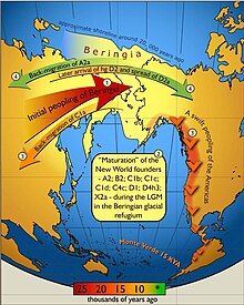
Map of gene flow in and out of Beringia, according to human mitochondrial DNA haplogroups. Colors of the arrows correspond to approximate timing of the events and are decoded in the colored time bar. The initial peopling of Beringia (the region depicted in light yellow) was followed by a standstill after which the ancestors of the Native Americans spread swiftly all over the New World while some of the Beringian maternal lineages (C1a) spread westwards. More recent genetic exchange (shown in green) is manifested by back-migration of A2a into Siberia and the spread of D2a into north-eastern America that post-dated the initial peopling of the New World.
Arctic Ocean map (language neutral version)


