Canet-en-Roussillon
| Canet-en-Roussillon | |
|---|---|
 Radnice v Canet-en-Roussillon | |
.svg) znak | |
| Poloha | |
| Souřadnice | 42°42′24″ s. š., 3°0′28″ v. d. |
| Nadmořská výška | 0–37 m n. m. |
| Časové pásmo | UTC+01:00 (standardní čas) UTC+02:00 (letní čas) |
| Stát | |
| Region | Okcitánie |
| Departement | Pyrénées-Orientales |
| Arrondissement | Perpignan |
| Kanton | Canet-en-Roussillon |
 Canet-en-Roussillon | |
| Rozloha a obyvatelstvo | |
| Rozloha | 30,22 km² |
| Počet obyvatel | 13 091 (2011) |
| Hustota zalidnění | 433 obyv./km² |
| Správa | |
| Starosta | Bernard Dupont |
| Oficiální web | www |
| PSČ | 66140 |
| INSEE | 66037 |
| Některá data mohou pocházet z datové položky. | |
Canet-en-Roussillon (katalánsky Canet de Rosselló) je jihofrancouzské přístavní město v departementu Pyrénées-Orientales na pobřeží Středozemního moře, asi 9,4 km od Perpignanu.
Geografie
Geografická poloha

Hydrologie
Politika
Seznam starostů
- 1944–1947 : Gabriel Henric
- 1947–1950 : Joseph Pagès
- 1950–1965 : François Moudat
- 1965–1966 : Christian Brignieu
- 1966–1971 : François Moudat
- 1971–1989 : Jacques Coupet
- 1989–2010 : Arlette Franco
- 2010- : Bernard Dupont
Vývoj počtu obyvatel
| 1936 | 1946 | 1954 | 1962 | 1968 | 1975 | 1982 | 1990 | 1999 | 2006 | 2011 |
|---|---|---|---|---|---|---|---|---|---|---|
| 1238 | 1213 | 1853 | 2646 | 3658 | 5127 | 7219 | 7575 | 10182 | 11702 | 13091 |

Kultura

Pamětihodnosti
- Kostel svatého Jakuba (Gotický sloh, 14.–16. století)
- Hrad (11.–14. století)
Významné osobnosti
- Joseph Cassanyes (1758–1843), poslanec.
Partnerské město
![]() Maynooth (Hrabství Kildare, Irština), 2011[4]
Maynooth (Hrabství Kildare, Irština), 2011[4]
Foto galerie
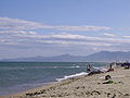 Pláž
Pláž Přístav
 Hrad
Hrad Knihovna
Literatura
- SAUT, Robert. Canet en Roussillon : regards sur 3000 ans d'histoire, Les Amis du Vieux Canet, 1991, 314 p. (francouzsky)
Související články
Externí odkazy
 Obrázky, zvuky či videa k tématu Canet-en-Roussillon na Wikimedia Commons
 - Oficiální stránky (francouzsky)
Reference
- ↑ Cassini. cassini.ehess.fr [online]. [cit. 2014-12-24]. Dostupné v archivu pořízeném dne 2014-01-16.
- ↑ INSEE 2006
- ↑ INSEE 2011
- ↑ J. R., Jumelage officiel Canet-Maynooth, L'Indépendant, 29/06/2011
 | Villelongue-de-la-Salanque | Sainte-Marie | | |
| Perpignan, Cabestany | Středozemní moře | |||
| Saint-Nazaire, Alénya | Saint-Cyprien |
Média použitá na této stránce

Autor: Superbenjamin, Licence: CC BY-SA 4.0
Blank administrative map of France for geo-location purpose, with regions and departements distinguished. Approximate scale : 1:3,000,000

Zelený pruh má znázorňovat většinové katolické obyvatelsto Irska, oranžový pruh reprezentuje protestantskou menšinu a bílý pruh uprostřed znázorňuje mír a harmonii mezi nimi.

A stylized arrow pointing north.

A stylized arrow pointing west.
A stylized arrow pointing east.

A stylized arrow pointing south.

Autor: Fabricio Cardenas, Licence: CC BY-SA 3.0
This building is indexed in the base Mérimée, a database of architectural heritage maintained by the French Ministry of Culture, under the reference PA00103978
Autor:
|
Map data (c) OpenStreetMap contributors, CC-BY-SA _French_municipality_map.svg) • Shape files infrastructure: railway, highways, water: all originally by OpenStreetMap contributors. Status december 2011 *note: shown commune boundaries are from OSM dump May 2012; at that time about 90% complete |
Map of French municipality

Autor: Fabricio Cardenas, Licence: CC BY-SA 4.0
Le port de plaisance de Canet-en-Roussillon
Autor: Michiel1972, Licence: CC BY-SA 3.0
Population - Municipality code 66037.svg
Population Census 1962-2008Autor: Fabricio Cardenas, Licence: CC BY-SA 3.0
The town hall in Canet-en-Roussillon
Autor: LeZibou, Licence: CC BY-SA 3.0
Canet-en-Roussillon (département of Pyrénées-Orientales, Languedoc-Roussillon région, France) : Saint-Jacques church. The belltower, built in the XVIth century on top of a tower which was part of the village fortification wall.

Autor: Fabricio Cardenas, Licence: CC BY-SA 4.0
The public library of Canet-en-Roussillon

Autor: Původně soubor načetl Lucas Destrem na projektu Wikipedie v jazyce francouzština, Licence: CC BY-SA 3.0
La plage. Canet-en-Roussillon, Pyrénées-Orientales, France.