Cerro Catedral (Uruguay)
| Cerro Catedral | |
|---|---|
 Vrchol Cerro Catedral nedaleko prašné cesty Ruta 109 | |
| Vrchol | 514 m n. m. |
| Prominence | 63 m |
| Seznamy | Nejvyšší hory amerických zemí |
| Poznámka | nejvyšší bod Uruguaye |
| Poloha | |
| Světadíl | Jižní Amerika |
| Stát | |
| Pohoří | Sierra Carapé, část Cuchilla Grande |
| Souřadnice | 34°22′51″ j. š., 54°40′25″ z. d. |
 Cerro Catedral | |
| Hornina | žula, rula |
| Některá data mohou pocházet z datové položky. | |
Cerro Catedral (též Cerro Cordillera, 514 m n. m.) je kopec v pohoří Sierra Carapé (součást pohoří Cuchilla Grande) v jihovýchodní části Jižní Ameriky. Leží na jihovýchodě Uruguaye v departementu Maldonado na území obce Aiguá. Jedná se o nejvyšší bod Uruguaye. Název je odvozen od tvaru skaliska na vrcholu.
Fotogalerie
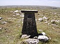
Geodetický bod na vrcholu kopce
Reference
V tomto článku byl použit překlad textu z článku Cerro Catedral (Uruguay) na anglické Wikipedii.
Externí odkazy
Média použitá na této stránce


Fire.svg
This is a solid red equilateral triangle, which can symbolize or indicate many things, including the the symbol for fire in the books by Franz Bardon.
This is a solid red equilateral triangle, which can symbolize or indicate many things, including the the symbol for fire in the books by Franz Bardon.
.svg)
Americas (orthographic projection).svg
Autor: Martin23230, Licence: CC BY-SA 3.0
Orthographic map of the Americas with national borders added
Autor: Martin23230, Licence: CC BY-SA 3.0
Orthographic map of the Americas with national borders added
CerroCatedral.jpg
Autor: Scheridon, Licence: CC BY-SA 3.0
Cerro Catedral (or Cerro Cordillera), the highest point in Uruguay, with an altitude of 513.66 metres (1,685.24 feet), near a dirt road (Ruta 109).
Autor: Scheridon, Licence: CC BY-SA 3.0
Cerro Catedral (or Cerro Cordillera), the highest point in Uruguay, with an altitude of 513.66 metres (1,685.24 feet), near a dirt road (Ruta 109).

Marco del Cerro Catedral.jpg
Autor: Scheridon, Licence: CC BY-SA 3.0
The summit of the Cerro Catedral (or Cerro Cordillera), the highest point of Uruguay, with an altitude of 513.66 metres (1,685.24 feet.)
Autor: Scheridon, Licence: CC BY-SA 3.0
The summit of the Cerro Catedral (or Cerro Cordillera), the highest point of Uruguay, with an altitude of 513.66 metres (1,685.24 feet.)
Uruguay location map Topographic.png
Autor: Dr Brains, Licence: GFDL
Location map of Uruguay
Autor: Dr Brains, Licence: GFDL
Location map of Uruguay
Equirectangular projection, Geographic limits of the map:
- N: 29.86° S
- S: 35.19° S
- W: 58,71° W
- E: 52,89° W