Mount Cleveland (Aljaška)
| Cleveland | |
|---|---|
 | |
| Vrchol | 1 730 m n. m. |
| Prominence | 1 730 m |
| Izolace | 90 km → Vsevidof |
| Poloha | |
| Světadíl | Severní Amerika |
| Stát | |
| Souřadnice | 52°49′20″ s. š., 169°56′42″ z. d. |
 Cleveland | |
| Typ | stratovulkán |
| Erupce | červen 2020 |
| Hornina | andezit, dacit |
| Některá data mohou pocházet z datové položky. | |
Mount Cleveland je aktivní sopka, nacházející se v ostrovním pásu Aleut v americkém státě Aljaška. Půdorysně symetrický stratovulkán, dosahující výšky 1 730 m, je součástí Ostrovů čtyř hor, skládající se z osmi ostrovů. Mount Cleveland, tvořící nejvyšší vrchol souostroví, leží na největším ostrově Čuginadak. Jde o jednu z nejaktivnějších sopek Aleutských ostrovů: během posledních 230 let měla 22 potvrzených erupcí. Poslední z nich se odehrála 1. června 2020.[1][2]
Galerie

 Formující se lávový dóm na dně kráteru.
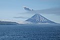
 Na fotce se Cleveland nachází na větším ostrově, mezi třemi zasněženými vrcholy.
 Cleveland v pozadí a Carlisle v popředí.
Odkazy
Reference
Externí odkazy
 Obrázky, zvuky či videa k tématu Cleveland (sopka) na Wikimedia Commons
Média použitá na této stránce


Fire.svg
This is a solid red equilateral triangle, which can symbolize or indicate many things, including the the symbol for fire in the books by Franz Bardon.
This is a solid red equilateral triangle, which can symbolize or indicate many things, including the the symbol for fire in the books by Franz Bardon.

Line4963 - Flickr - NOAA Photo Library.jpg
Mount Cleveland Volcano. Alaska, Aleutian Islands, Kagamil Island.
Mount Cleveland Volcano. Alaska, Aleutian Islands, Kagamil Island.

Mt. Cleveland Lava Dome.jpg
This is a recent aerial photo taken on August 4, 2015 showing the lava dome within the Cleveland volcano summit crater. The volcano continues to see low-level unrest.
This is a recent aerial photo taken on August 4, 2015 showing the lava dome within the Cleveland volcano summit crater. The volcano continues to see low-level unrest.
MountCleveland.jpg
From the USGS caption: Mount Cleveland forms the western half of Chuginadak Island in the central Aleutian Islands. This symmetrical, 1,730-m (5,676 ft)-high stratovolcano and has been the site of numerous eruptions in the last two centuries; the most recent eruption occurred in 1994. In 1944, a U.S. Army serviceman was reportedly killed by an eruption from Mount Cleveland.
From the USGS caption: Mount Cleveland forms the western half of Chuginadak Island in the central Aleutian Islands. This symmetrical, 1,730-m (5,676 ft)-high stratovolcano and has been the site of numerous eruptions in the last two centuries; the most recent eruption occurred in 1994. In 1944, a U.S. Army serviceman was reportedly killed by an eruption from Mount Cleveland.

Cleveland Volcano.jpg
Jealous? — This photo was taken last summer when scientists from the Islands of Four Mountains science project headed ashore by skiff on the first day of fieldwork. In the backdrop is Cleveland volcano. The USGS provides the latest updates on the status of Cleveland including ash cloud forecasts, images, and more at: bitly.com/ClevelandVolcano. Photo Credit: Christina Neal, USGS.
Jealous? — This photo was taken last summer when scientists from the Islands of Four Mountains science project headed ashore by skiff on the first day of fieldwork. In the backdrop is Cleveland volcano. The USGS provides the latest updates on the status of Cleveland including ash cloud forecasts, images, and more at: bitly.com/ClevelandVolcano. Photo Credit: Christina Neal, USGS.
We've also just launched a "USGS Volcanoes" Facebook Page covering the various volcano research, status updates, and more. Go ahead and like the page and keep up to date with what's happening: www.facebook.com/USGSVolcanoes.
For more information on the Island of Four Mountains project, visit: www.facebook.com/IslandsOfThe4Mountains/..jpg)
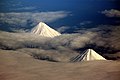
A View From Above (17182411827).jpg
A View From Above — A view of the flanks of Cleveland volcano (top) and Carlisle volcano (bottom) viewed from an Alaska Airlines 737 en route to Adak, Alaska. The photo was taken on May 31, 2012. Currently, Cleveland volcano is at a yellow alert level and recently had a small steam event. Photo credit: Cyrus Read, USGS.
A View From Above — A view of the flanks of Cleveland volcano (top) and Carlisle volcano (bottom) viewed from an Alaska Airlines 737 en route to Adak, Alaska. The photo was taken on May 31, 2012. Currently, Cleveland volcano is at a yellow alert level and recently had a small steam event. Photo credit: Cyrus Read, USGS.

ISS065-E-140784 - View of Alaska.jpg
View of Alaska taken during ISS Expedition 65.
View of Alaska taken during ISS Expedition 65.

Line4965 - Flickr - NOAA Photo Library.jpg
Mount Cleveland erupting ash. Alaska, Aleutian Islands, Kagamil Island.
Mount Cleveland erupting ash. Alaska, Aleutian Islands, Kagamil Island.