Coahuila y Tejas
| Coahuila y Tejas Estado Libre y Soberano de Coahuila y Tejas
| |||||||||
Geografie
| |||||||||
Saltillo, později Monclova | |||||||||
800 000 km² | |||||||||
| Obyvatelstvo | |||||||||
70 955 (1828) | |||||||||
| Státní útvar | |||||||||
stát Spojených států mexických | |||||||||
Vznik | |||||||||
Zánik | |||||||||
| Státní útvary a území | |||||||||
| |||||||||
Coahuila y Tejas (Coahuila a Texas) byl jeden se zakládajících členů novozaloženého státu Spojené státy mexické na základě Ústavy z roku 1824.[1]
Oblast měla dvě hlavní města: nejprve Saltillo a později Monclova. Pro administrativní účely, stát byl rozdělen do tří částí: Béxar, Monclova a Rio Grande Saltillo. Teritorium Bexar byl přibližně dnešní Texas, Monclova zahrnovala severní Coahuilu, a Río Grande Saltillo jižní Coahuilu.
Existence státu Coahiula y Tejas trvala až do roku 1835, kdy po přijetí nové ústavy se federální republika stala unitárním státem, a státy (estados) se staly departmenty (departamentos). Stát Coahuila y Texas byl rozdělen na dvě části a obě se staly departmenty, Department of Coahuila a Department of Texas. Department Texas se oddělil a stal se nezávislou Texaskou republikou, která je teď státem Texas a součástí Spojených států amerických.
Oba regiony Coahuila i Texas se oddělily od Mexika z důvodu snahy mexického prezidenta Santa Anny centralizovat moc v státě. Texas vytvořil Texaskou republiku a Coahuila se spojila s Novým Leónem a Tamaulipas aby zformovala republiku Rio Grande, která ale neměla dlouhé trvání.
Vznik
V roce 1821, po Mexické válce za nezávislost Španělsko ztratilo kontrolu nad svými severoamerickými teritorii a byl zformován nový stát na bývalém území Nového Španělska. V prvních dnech vzniku nového státu probíhaly rozsáhlé diskuse, jestli se Mexiko má stát federální republikou, nebo konstituční monarchií. Nová ústava v roce 1824 ustanovila krajinu jako federální republiku s devatenácti státy a čtyři teritorii. Jedním z nových státu byl Coahuila y Texas, který spojil řídce osídlené španělské provincie Texas a Coahuila.[2][3] V mexické federaci byl stát nejchudším.[4] Území Coahuila y Tejas zahrnovalo hranice španělského Texasu, ale nezahrnovalo území kolem El Pasa, které patřilo státu Chihuahua a území kolem Lareda v Texasu, které bylo součástí mexického státu Tamaulipas.[2]
Erasmo Seguin, zástupce Texasu v mexickém Kongresu v období ústavních změn, původně zastával názor o samostatnosti pro Texas. Uvědomoval si skutečnost, že malý počet obyvatel a nedostatečné zdroje by nebyly zárukou správného fungování státu a kdyby Texas zůstal teritoriem, federální vláda by měla povinnost pomáhat teritoriím. Protože Coahuila měla víc obyvatel než Texas, obával se, že v kombinovaném státě by získala také větší vliv v rozhodovacím procesu. Zástupce z Coahuily, Miguel Ramos Arizpe, byl rovněž přesvědčen, že jeho region je špatně připraven na skutečnost, aby se stal samostatným státem. Ramos Arizpe se nebyl ochoten spojit s okolními státy, protože Coahuila v porovnání s nimi měla buď malý počet obyvatel nebo slabší ekonomiku a byla by tedy slabším partnerem. Ramos Arizpe napsal dopis ayuntamientovi v Bexaru s varováním, že v případě, kdy se Texas rozhodne stát se teritoriem, ztratí své vlastnictví veřejné půdy v prospěch federální vlády. Tato skutečnost byla dostačující na to, aby přesvědčila Texasany aby se vzdali své opozice proti spojení s Coahuilou.[5]
Přistěhovalectví
Federální mexická vláda neměla prostředky na vojenskou ochranu a osadníci si mohli zakládat vlastní ochranné oddíly, které by pomohly kontrolovat nepřátelské indiánské kmeny. Hraniční region Texasu byl předmětem častých útoků kmenů Apačů a Komančů. V naději, že příliv osadníku by mohl zabránit nájezdům, vláda liberalizovala imigrační politiku a osadníkům ze Spojených států bylo dovoleno usadit se v Mexiku.[6]
Státy byly zodpovědné za aplikaci Zákona o kolonizaci. Úřední místa v Saltille, hlavním městě Coahuila y Texas, byla za krátkou dobu obležena spekulanty s půdou, kteří chtěli získat území v Texasu. Stát schválil v roce 1825 svůj vlastní kolonizační zákon. Přistěhovalci a naturalizovaní občané podali přibližně 3420 žádostí o půdu, většina z nich byli Angloameričani. Jen jediný z 24 empresarios, Martín De León, usadil přistěhovalce z Mexika, ostatní empresarios přivedli osadníky většinou ze Spojených států.[7][8]
Ekonomika
Území státu bylo většinou zemědělsky soběstačným regionem, jenom malá část potravin se vyvážela. Bylo to z důvodu nedostatku pracovních sil a částečně z důvodu nájezdů indiánských kmenů.
V části Texasu hospodářství záviselo na pěstování bavlny. V roce 1834 Texas exportoval víc než 7 000 balů bavlny. Rančerství bylo taky lukrativní, v roce 1834 Texas exportoval víc než 5000 kusů dobytka. Dřevo bylo exportováno v malém množství. V polovině třicátých let 19. století Texas dovážel zboží v hodnotě 630 000 dolarů. Hodnota exportu představovala 500 000 dolarů.
V letech 1823-1830 měli osadníci v Texasu celní výjimky na některé druhy dováženého zboží. Celní poplatky ale nemohly být vybírány z důvodu neexistence celních orgánů. V Anahuacu byla ustanovena celnice v roce 1830, ale vojáci byli vyhnáni osadníky v roce 1832. Podobný incident se odehrál v roce 1835.
Většina hospodářství byla v rukou posledních přistěhovalců, jen několik Tejanos bylo zaangažováno v exportu nebo v průmyslu.[9]
Demografie
Přes příliv osadníku ze Spojených států v období po schválení kolonizačních zákonů většina osadníku v státě Coahuila y Tejas byli původní mexičtí občané. V Texasu ale v roce 1830 přibližně 80% obyvatelstva pocházelo ze Spojených států nebo z Evropy.
Galerie
 1833
1833 1834
1834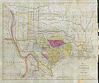 1836
1836
Reference
- ↑ 5th. Article of Mexican Constitution of 1824 Archivováno 16. 8. 2018 na Wayback Machine..
- ↑ a b Manchaca (2001), p. 162.
- ↑ Vazquez (1997), p. 51.
- ↑ de la Teja (1997), p. 85.
- ↑ Weber (1982), p. 24.
- ↑ Manchaca (2001), p. 164.
- ↑ de la Teja (1997), p. 88.
- ↑ Manchaca (2001), p. 199.
- ↑ Weber (1982), p. 141.
Literatura
- WEBER, David J. The Mexican frontier, 1821-1846: the American Southwest under Mexico. [s.l.]: University of New Mexico Press, 1982. (Histories of the American frontier). ISBN 9780826306036.
- MANCHACA, Martha. Recovering History, Constructing Race: The Indian, Black, and White Roots of Mexican Americans. Austin, TX: University of Texas Press, 2001. (The Joe R. and Teresa Lozano Long Series in Latin American and Latino Art and Culture). ISBN 0292752539.
- DE LA TEJA, Jesus F. Myths, Misdeeds, and Misunderstandings: The Roots of Conflict in U.S.–Mexican Relations. Redakce Rodriguez O. Jaime E.. Wilmington, DE: Scholarly Resources Inc., 1997. ISBN 0842026622. Kapitola The Colonization and Independence of Texas: A Tejano Perspective.
- VAZQUEZ, Josefina Zoraida. Myths, Misdeeds, and Misunderstandings: The Roots of Conflict in U.S.–Mexican Relations. Redakce Rodriguez O. Jaime E.. Wilmington, DE: Scholarly Resources Inc., 1997. ISBN 0842026622. Kapitola The Colonization and Loss of Texas: A Mexican Perspective.
Externí odkazy
 Obrázky, zvuky či videa k tématu Coahuila y Tejas na Wikimedia Commons
 - Coahuila y Tejas: From liberal federalism to centralista dictatorship
- Compendium of Mexican Constitutions (španělsky)
- Mapa státu Coahuila a Texas z roku 1833 / W. Hooker, sculpt. na portálu Portal to Texas History.
- Zákon a dekrety Coahuila a Texas Gammel's Laws of Texas, Vol. I. na portálu Portal to Texas History.
Média použitá na této stránce

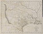
Philadelphia engraver, printer, map publisher, and instrument maker William Hooker's Map of Coahuila and Texas first appeared in an 1833 promotional book on Texas by Mary Austin Holley (1784-1846), a first cousin of the famous Texas colonizer Stephen F. Austin. Holley and her first publisher, Armstrong & Plaskitt of Baltimore substituted Hooker's map when Henry S. Tanner, the publisher of Stephen F. Austin's large map of Texas, refused to allow the latter to be used in the book. Both the 1836 map and book have some significant updates from the earlier map and book. Like the map by Hooker that appeared in A Visit to Texas, published by Goodrich & Wiley in New York in 1834, the 1836 map contains all the details of the earlier 1833 version but indirectly also refers to empresarios John McMullen and James McGloin, James Power, John Cameron, other new details such as "Herds of Buffalo" and "Droves of Wild Cattle & Horses" (phrases copied directly from the Austin-Tanner map) and peaks in the west, "Presidio de Rio Grand" [sic], additional towns across the Rio Grande in Chihuahua and Coahuila, the Cross Timbers, Fort Tenoxtitlan, Comanche Indian lands in the west, Cherokee, Creek, and Choctaw Indian lands north of the Red River. In addition, this 1836 map adds other details, such as references to the grants of Juan Antonio Padilla and Thomas Jefferson Chambers in the panhandle (awarded in 1830), and those of John Charles Beale and Dr. James Grant in the west. Further, the map includes the towns of Bastrop, Gonzales, Cole's Settlement (Independence), Montezuma, Orizumba, Columbia, Bell's Landing, and De Leon's colony. The words "now Filisola" are stamped in northeast Texas next to Thorn's Grant – referring to an empresario land grant awarded in 1831 to Italian-born Mexican Army General Vicente Filisola (1789-1850). Handwritten additions in ink on the map are references to Benjamin Milam's grant in the far northeast and the towns of Washington (on the Brazos), Corpus Christi, and [San] Augustine.


Flag of Coahuila

Reconstrucción de la Bandera de México usada de 1821 a 1823 durante el Primer Imperio Mexicano. Bandera tricolor, proporciones 2:3, un águila con corona posada sobre un nopal.

Philadelphia engraver, printer, map publisher, and instrument maker William Hooker's Map of Coahuila and Texas first appeared in an 1833 promotional book on Texas by Mary Austin Holley (1784-1846), a first cousin of the famous Texas colonizer Stephen F. Austin. Holley and her publisher, Armstrong & Plaskitt of Baltimore substituted Hooker's map when Henry S. Tanner, the publisher of Stephen F. Austin's large map of Texas, refused to allow the latter to be used in the book. Hooker's map shows the Austin Colony capital town of San Felipe de Austin at the center of roads leading to a number of settlements including Bexar (San Antonio de Bexar), Victoria and Goliad or Bahia, Matagorda, Brazaria (sic, Brazoria), Harrisburg and Buffalo Bayou as well as a road connecting to the older Camino Real or old Spanish road between Bexar and Nacogdoches. Lands granted to individuals under the Mexican empresario system are shown. In addition to Stephen F. Austin's grants awarded in 1821 (confirmed in 1823 and extended by further contracts in 1825, 1827, and 1828), these include the grants of Green DeWitt (contract awarded in 1825), Frost Thorn (1825), Benjamin R. Milam (1826), David G. Burnet (1826), Arthur G. Wavell (1826), Joseph Vehlein (1826 and 1828), Lorenzo de Zavala (1829), Juan Dominguez y Valdez (1829), Richard Exter (1826, 1828), John Charles Beale (1830). The lands in west Texas granted to Beale and José Manuel Royuela and to Austin and his partner Samuel May Williams in 1832 are the latest to appear on the map. References to other land grants are missing but some would appear on later editions in 1834 and 1836.
.svg)
Autor: Milenioscuro, Licence: CC BY-SA 4.0
Locator map of Coahuila y Texas state in Mexico (1824)

Philadelphia engraver, printer, map publisher, and instrument maker William Hooker's Map of Coahuila and Texas first appeared in an 1833 promotional book on Texas by Mary Austin Holley (1784-1846), a first cousin of the famous Texas colonizer Stephen F. Austin. Holley and her publisher, Armstrong & Plaskitt of Baltimore substituted Hooker's map when Henry S. Tanner, the publisher of Stephen F. Austin's large map of Texas, refused to allow the latter to be used in the book. This later colored version Hooker's map appeared in an anonymous travel book on Texas sometime attributed to a certain "M. Fiske" of Mobile, Alabama. The author had sailed from New Orleans in March 1831 and had arrived in Brazoria (incorrectly spelled "Brazaria" on the map) to examine a large tract of land he had purchased from the Galveston Bay and Texas Land Company.
This 1834 map contains all the details of the earlier 1833 version but also refers to John McMullen and James McGloin's grant (contract awarded in 1828), James Power's grant (also awarded in 1828) — both in south Texas — as well as cryptic references to "J. Camerou" in North Texas (John Cameron, who was awarded a contract in 1827) and "De Leon" (Martin De Leon, awarded a contract in 1824). Other new details include "peaks in the west", "Presidio de Rio Grand" [sic], additional towns across the Rio Grande in Chihuahua and Coahuila, the Cross Timbers, "Tenoxticlan" (Fort Tenoxtitlan, constructed for the Mexican army in 1830), "Herds of Buffalo" and "Droves of Wild Cattle & Horses" (phrases copied directly from the Austin-Tanner map), Comanche Indian lands in the west, and Cherokee, Creek, and Choctaw Indian lands north of the Red River.