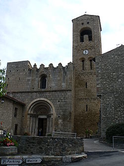
Corneilla-de-Conflent
| Corneilla-de-Conflent | |
|---|---|
 Románský kostel Sainte-Marie | |
| Poloha | |
| Souřadnice | 42°34′3″ s. š., 2°22′53″ v. d. |
| Nadmořská výška | 397–823 m n. m. |
| Stát | |
| Region | Languedoc-Roussillon |
| Departement | Pyrénées-Orientales |
| Arrondissement | Prades |
| Kanton | Prades |
| Rozloha a obyvatelstvo | |
| Rozloha | 11,02 km² |
| Počet obyvatel | 464 (2011) |
| Hustota zalidnění | 42 obyv./km² |
| Správa | |
| Starosta | Patrice Arro |
| PSČ | 66820 |
| INSEE | 66057 |
| Některá data mohou pocházet z datové položky. | |
Corneilla-de-Conflent (kat. Cornellà de Conflent) je vesnice na severním úbočí Pyrenejí v departementu Pyrénées-Orientales.
Počátky místa jsou datovány do 9. století, kdy zde bylo sídlo hrabat z Cerdagne a augustiniánské opatství, které založil roku 1097 Vilém Jordan z Cerdagne. Mezi hlavní pamětihodnosti vsi patří opevněný románský kostel sv. Marie s tympanonem, na kterém je trůnící Madona s dítětem obklopená anděly.
Geografie
Významné osobnosti
- George-Daniel de Monfreid (1856-1929), malíř
- Victor Dalbiez (1876-1954), francouzský politik a senátor
Související články
Externí odkazy
 Obrázky, zvuky či videa k tématu Corneilla-de-Conflent na Wikimedia Commons
Média použitá na této stránce
Autor: Superbenjamin, Licence: CC BY-SA 4.0
Blank administrative map of France for geo-location purpose, with regions and departements distinguished. Approximate scale : 1:3,000,000
Autor:
|
Map data (c) OpenStreetMap contributors, CC-BY-SA  • Shape files infrastructure: railway, highways, water: all originally by OpenStreetMap contributors. Status december 2011 *note: shown commune boundaries are from OSM dump May 2012; at that time about 90% complete |
Map of French municipality


