Cumberland

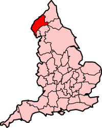
Cumberland je historická oblast na severozápadě Anglie, do roku 1974 byl jedním z tradičních hrabství. Měl rozlohu 3938 km² a zhruba 300 000 obyvatel, hlavním městem bylo Carlisle.
Historie
O Cumberlandu se poprvé zmiňuje Anglosaská kronika v roce 945. Oblast byla předmětem sporů mezi Anglií a Skotskem, definitivně ji k Anglii připojila až Smlouva z Yorku roku 1237. V roce 1889 byl Cumberland ustanoven administrativním hrabstvím a při reformě územního členění Anglie v roce 1974 byl spojen s Westmorlandem do nového hrabství Cumbria.
Přírodní poměry

Cumberland je hornatý a na anglické poměry řídce osídlený kraj, nachází se zde nejvyšší anglická hora Scafell Pike (978 m). V Cumberlandu leží Lake District, největší anglický národní park.
Vnitřní členění
Okresy Cumberlandu a počet obyvatel podle sčítání 1971:
- County Borough of Carlisle (71 580)
- Cockermouth Urban District (6 366)
- Keswick Urban District (5 184)
- Maryport Urban District (11 612)
- Penrith Urban District (11 308)
- Municipal Borough of Whitehaven (26 721)
- Municipal Borough of Workington (28 431)
- Alston with Garrigill Rural District (1 917)
- Border Rural District (29 267)
- Cockermouth Rural District (21 520)
- Ennerdale Rural District (30 983)
- Millom Rural District (14 088)
- Penrith Rural District (11 380)
- Wigton Rural District (21 830)
Externí odkazy
 Obrázky, zvuky či videa k tématu Cumberland na Wikimedia Commons
Média použitá na této stránce
Autor: Diliff, Licence: CC BY-SA 3.0
The village of Glenridding and Ullswater in the Lake District, Cumbria, England. This view is looking east from the hills at the start of the ascent to Helvellyn.
County flag of Cumberland


