Daedalus (kráter)
| Kráter Daedalus | |
|---|---|
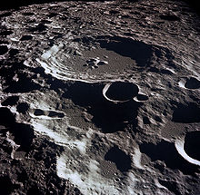
 Snímek kráteru Daedalus při pohledu z Apolla 11. | |
| Souřadnice na Měsíci | |
| Selenografická šířka | 5,9° J [1] |
| Selenografická délka | 179,4° V [1] |
| Další údaje | |
| Typ kráteru | ? |
| Průměr kráteru | 93,6 km [1] |
| Hloubka | 3 km |
| Colongitudo | 181° |
| Eponym | Daidalos |
Daedalus je impaktní měsíční kráter nacházející se poblíž středu odvrácené strany Měsíce a tudíž není pozorovatelný přímo ze Země. Díky své poloze je navrhován pro umístění budoucího obřího radioteleskopu podobného radioteleskopu v Arecibu, ale s mnohem většími rozměry.[2] Jeho původní název je Kráter 308 a Mezinárodní astronomická unie ho později pojmenovala po staviteli z řecké mytologie Daidalovi.
Poblíž tohoto kráteru se na východě nachází kráter Icarus, na jihu Racah a severoseverovýchodně Lipskij.
Satelitní krátery


V tabulce jsou krátery, které souvisí s kráterem Daedalus.
| Daedalus | Sel. šířka | Sel. délka | Průměr |
|---|---|---|---|
| B | 4.1° J | 179.8° Z | 23 km |
| C | 4.1° J | 178.9° Z | 68 km |
| G | 6.6° J | 177.4° Z | 33 km |
| K | 8.3° J | 178.5° Z | 24 km |
| M | 8.1° J | 179.5° V | 13 km |
| R | 7.7° J | 175.2° V | 41 km |
| S | 6.8° J | 172.9° V | 20 km |
| U | 4.2° J | 174.9° V | 30 km |
| W | 3.5° J | 177.5° V | 70 km |
Reference
- ↑ a b c Crater Daedalus on Moon Gazetteer of Planetary Nomenclature, IAU, USGS (anglicky)
- ↑ Kráter Daedalus místem pro umístění teleskopu (pl). news.astronet.pl [online]. [cit. 2010-02-16]. Dostupné v archivu pořízeném z originálu dne 2005-12-17.
Externí odkazy
 Obrázky, zvuky či videa k tématu Daedalus na Wikimedia Commons
 - Lunar Orbiter photographic atlas, Photo Number II-033-M
Média použitá na této stránce
The largest crater in the picture is Daedalus. Located near the center of the far side of the en:Moon, its diameter is about 93 kilometers (58 miles). This image was taken by en:Apollo 11 with Daedalus being Crater 308.
The largest crater in the picture is Gassendi. Located near the center of the far side of the Moon, its diameter is about 110 kilometers (68 miles). This image was taken by Apollo 11.
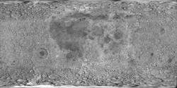
cylindrical map projection of the Moon. The Moon's whole surface was mapped by the Clementine spacecraft in 1994, here North is at the top. The dark floor of crater Plato is at the middle top above Mare Imbrium, while the bright floor and rays of crater Tycho is near the middle bottom below Mare Imbrium. Mare Procellarum is at the near left, and Mare Tranquillitatis is just right of centre and Mare Crisium is at the near right. The far left and far right show the contrast of the mostly cratered farside with small isolated mare.


