Drakeův průliv


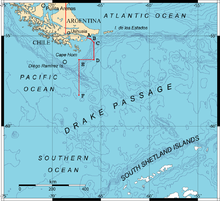
Drakeův průliv je průliv mezi jihoamerickou pevninou (Hornův mys) a Jižními Shetlandami (Antarktida). Leží jižně od Magalhãesova průlivu.
Spojuje Atlantský a Tichý oceán. Byl pojmenován podle viceadmirála Sira Francise Drakea.
- Šířka – 800–950 km, nejširší na světě
- Největší hloubka – 5248 m
- Průtok – cca 135 mil. m³/s
- Výskyt častých prudkých bouří
Externí odkazy
 Obrázky, zvuky či videa k tématu Drakeův průliv na Wikimedia Commons
 - Map Pack: Real Reason Ships Don't Pass Under South America (It's Not the Distance) na YouTube (anglicky)
Média použitá na této stránce
Autor: Hannes Grobe, Alfred Wegener Institute for Polar and Marine Research, Licence: CC BY-SA 2.5
Profile through the Drake Passage between South America and the Antarctic Peninsula. Morphological main features in the deep sea are shown like the mid ocean ridge (West Scotia Ridge), separating the Antarctic plate from the South American plate. The South Shetland Islands belong to an island belt, resulting from the subduction of the Pacific plate below the Antarctic plate. In the back arc basin, i.e. the Bransfield Strait, submarine volcanoes have been found.
The upper graph shows salinity (parts per thousand) and temperature in surface water measured along a cruise track. The Polar Front is an oceanographic feature which is characterized by an abrupt change in temperature by about one degree.Autor: GMT (OMC) base map modified by Giovanni Fattori, Licence: CC BY-SA 3.0
Drake Passage Map showing the boundary through points A, B, C, D, E and F accorded between Chile and Argentina by the Tratado de Paz y Amistad of 1984.


