Eratosthenes (kráter)
| Kráter Eratosthenes | |
|---|---|
 Snímek kráteru Eratosthenes při pohledu z Apolla 17. | |
| Souřadnice na Měsíci | |
| Selenografická šířka | 14,5° S |
| Selenografická délka | 11,3° Z |
| Další údaje | |
| Typ kráteru | komplexní kráter |
| Průměr kráteru | 59 km |
| Hloubka | 3,6 km |
| Colongitudo | 12° |
| Eponym | Eratosthenés z Kyrény |

Eratosthenes je impaktní měsíční kráter nacházející se poblíž středu přivrácené strany Měsíce. Leží na okraji měsíčního moře Mare Imbrium, měsíčního pohoří Apeniny a zálivu Sinus Aestuum. Nazván byl po starořeckém matematikovi, astronomovi a geografovi Eratosthenovi z Kyrény.[1]
Kráter Eratosthenes je starý pravděpodobně 3,2 mld. let a bylo po něm nazváno jedno z geologických období Měsíce (Eratosthénská éra).[2]
Popis vzhledu
Průměr kráteru je 59 km a jeho dno se nachází v hloubce 3 600 m. Je to komplexní kráter s výraznými centrálními vrcholky a terasovitými vnitřními stěnami.[3] Kolem kráteru lze nalézt systém paprsků, který byl však na západní části překryt jiným systémem, který vznikl při vzniku mladšího, a proto i výraznějšího kráteru Koperník.
Satelitní krátery
V tabulce jsou krátery, které souvisí s kráterem Eratosthenes.
| Eratosthenes | Sel. šířka | Sel. délka | Průměr |
|---|---|---|---|
| A | 18.4° S | 8.3° Z | 6 km |
| B | 18.7° S | 8.7° Z | 5 km |
| C | 16.9° S | 12.4° Z | 5 km |
| D | 17.5° S | 10.9° Z | 4 km |
| E | 18.0° S | 10.9° Z | 4 km |
| F | 17.7° S | 9.9° Z | 4 km |
| H | 13.3° S | 12.2° Z | 3 km |
| K | 12.9° S | 9.2° Z | 5 km |
| M | 14.0° S | 13.6° Z | 4 km |
| Z | 13.8° S | 14.1° Z | 1 km |
Odkazy
Reference
- ↑ Crater Eratosthenes on Moon Gazetteer of Planetary Nomenclature, IAU, USGS (anglicky)
- ↑ Gabzdyl P.: Měsíc, AVENTINUM s.r.o., Praha 2006, ISBN 80-86858-22-7, str. 193
- ↑ RÜKL, Antonín. Atlas Měsíce. Praha: Aventinum, 1991. ISBN 80-85277-10-7. Kapitola Timocharis, s. 68/21.
Související články
Externí odkazy
 Obrázky, zvuky či videa k tématu Eratosthenes na Wikimedia Commons
 - Snímek Kráteru Eratosthenes Archivováno 2. 3. 2018 na Wayback Machine (anglicky)
- LAC 58, mapa 1:1 000 000 (Mercatorovo zobrazení)
Média použitá na této stránce
Autor: Srbauer, Licence: CC BY-SA 3.0
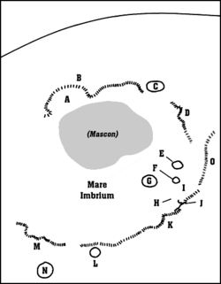
A map of Mare Imbrium.
- A: Sinus Iridum (Regenbogenbucht)
- B: Montes Jura (Jura-Gebirge)
- C: Plato
- D: Montes Alpes (Alpen)
- E: Aristillus
- F: Autolycus
- G: Archimedes
- H: Palus Putretinis (Sumpf der Fäulnis)
- I: Hadley Rille
- J: Apollo 15 landing site
- K: Montes Apenninus (Apenninen)
- L: Erathostenes
- M: Montes Carpatus (Karpaten)
- N: Copernicus
- O: Montes Caucasus (Kaukasus)
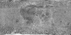
cylindrical map projection of the Moon. The Moon's whole surface was mapped by the Clementine spacecraft in 1994, here North is at the top. The dark floor of crater Plato is at the middle top above Mare Imbrium, while the bright floor and rays of crater Tycho is near the middle bottom below Mare Imbrium. Mare Procellarum is at the near left, and Mare Tranquillitatis is just right of centre and Mare Crisium is at the near right. The far left and far right show the contrast of the mostly cratered farside with small isolated mare.
Crater Eratosthenes and western part of Montes Apenninus (detail of LRO - WAC global moon mosaic; Mercator projection)
Autor: Exoexo, Licence: CC BY-SA 3.0
Eratosthenes crater on the Moon, taken from Bulgaria from amateur astrophotographer Georgi Georgiev.
Eratosthenes crater on the Moon from Apollo 17. The image has been rotated 90° to put north at top, and the edges have been cropped slightly. Copernicus crater is at the horizon in the lower right.


