Etterbeek
| Etterbeek | |
|---|---|
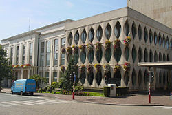
 Etterbeecká radnice | |
| Poloha | |
| Souřadnice | 50°50′12″ s. š., 4°23′13″ v. d. |
| Časové pásmo | SEČ/SELČ |
| Stát | |
| region | Bruselský region |
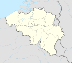
(c) Karte: NordNordWest, Lizenz: Creative Commons by-sa-3.0 de Etterbeek | |
| Rozloha a obyvatelstvo | |
| Rozloha | 3,2 km² |
| Počet obyvatel | 48 473 (2020)[1] |
| Hustota zalidnění | 15 243,1 obyv./km² |
| Správa | |
| Oficiální web | www |
| communication | |
| Adresa obecního úřadu | Avenue d'Auderghem/ Oudergemselaan 113/115 1040 Brüssel |
| Telefonní předvolba | 02 |
| PSČ | 1040 |
| Některá data mohou pocházet z datové položky. | |
Etterbeek je obec v Bruselském regionu v Belgii. Nachází se jižně od parku Jubelpark, nedaleko evropské čtvrti, kde sídlí celá řada institucí EU. Žije zde přibližně 48 tisíc[1] obyvatel.
Významní rodáci
- Constantin Meunier, malíř a sochař (1831–1905)
- Herman Van Rompuy, politik (* 1947)
- Jérôme d'Ambrosio, závodník (* 1985)
- Hergé, kreslíř (1907–1983)
Odkazy
Reference
- ↑ a b Bevolking per gemeente op 1 januari 2020. Dostupné online.
Externí odkazy
 Obrázky, zvuky či videa k tématu Etterbeek na Wikimedia Commons
 - Oficiální stránky
Média použitá na této stránce
This is the national flag of Belgium, according to the Official Guide to Belgian Protocol. It has a 13:15 aspect ratio, though it is rarely seen in this ratio.
Its colours are defined as Pantone black, Pantone yellow 115, and Pantone red 032; also given as CMYK 0,0,0,100; 0,8.5,79,0; and 0,94,87,0.(c) Karte: NordNordWest, Lizenz: Creative Commons by-sa-3.0 de
Location map of Belgium
Autor: Olivier1961, Licence: CC BY-SA 3.0
Coat of arms of the municipality of Etterbeek, Brussels, Belgium
Flag of the Belgian municipality Etterbeek. The municipal flag of Etterbeek is vertically divided blue-white.
Autor: No machine-readable author provided. David Edgar assumed (based on copyright claims)., Licence: CC BY-SA 3.0
Photo of the Etterbeek Maison Communale (town hall) taken by David Edgar on 2005-08-28.


