Euler (kráter)
| Kráter Euler | |
|---|---|
 Kráter Euler | |
| Souřadnice na Měsíci | |
| Selenografická šířka | 23,3° S |
| Selenografická délka | 29,2° Z |
| Další údaje | |
| Typ kráteru | kruhové pohoří |
| Průměr kráteru | 28 km [1] |
| Hloubka | 2,2 km |
| Colongitudo | 28° |
| Eponym | Leonhard Euler |
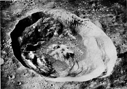
Euler je impaktní kráter typu kruhového pohoří nacházející se v jihozápadní části měsíčního moře Mare Imbrium (Moře dešťů) na přivrácené straně Měsíce. Má průměr 28 km, terasovité okrajové valy a na dně centrální formaci vyvýšenin.
Západo-jihozápadně lze nalézt horu Mons Vinogradov, o dost dále východo-severovýchodně srovnatelně velký kráter Lambert.[1] Jihozápadně se táhne brázda Rima Euler.
Název
Pojmenován je podle švýcarského matematika Leonharda Eulera.[2][1]
Satelitní krátery
V okolí kráteru se nachází několik dalších kráterů. Ty byly označeny podle zavedených zvyklostí jménem hlavního kráteru a velkým písmenem abecedy.[1][2]
| Euler | Sel. šířka | Sel. délka | Průměr |
|---|---|---|---|
| E | 24.7° S | 34.0° Z | 6 km |
| F | 21.2° S | 27.9° Z | 6 km |
| G | 20.7° S | 27.4° Z | 4 km |
| H | 25.3° S | 28.6° Z | 4 km |
| J | 22.3° S | 31.5° Z | 4 km |
| L | 21.4° S | 28.9° Z | 4 km |
Přejmenované krátery:
- Euler K na Jehan
- Euler P na Natasha
Odkazy
Reference
Literatura
- RÜKL, Antonín. Atlas Měsíce. Praha: Aventinum, 1991. ISBN 80-85277-10-7.
Externí odkazy
 Obrázky, zvuky či videa k tématu Euler na Wikimedia Commons
 - Kráter Euler Archivováno 28. 2. 2018 na Wayback Machine, Wikispaces.com (anglicky)
- LAC 40, mapa 1:1 000 000 (Lambertova projekce)
Média použitá na této stránce
Craters Brayley and Euler (detail of LRO - WAC global moon mosaic)
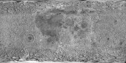
cylindrical map projection of the Moon. The Moon's whole surface was mapped by the Clementine spacecraft in 1994, here North is at the top. The dark floor of crater Plato is at the middle top above Mare Imbrium, while the bright floor and rays of crater Tycho is near the middle bottom below Mare Imbrium. Mare Procellarum is at the near left, and Mare Tranquillitatis is just right of centre and Mare Crisium is at the near right. The far left and far right show the contrast of the mostly cratered farside with small isolated mare.
This is an oblique image of Euler crater on the Moon, taken from orbit during the Apollo 17 mission. This is figure 139 from Apollo Over the Moon, NASA SP-362 (1978), which has the following caption:
In this oblique view of Euler some details are shown that are not visible in figures 137 and 138. Note, for example, the ledges (L) of bedrock cropping out along the south wall and the low terraces (T) at the points of contact between the slump masses and the floor. They may be aprons of debris or "bathtub rings" of lava like those shown earlier in figure 69. This oblique viewing angle also enhances the polygonal outline of Euler's rim crest and the size and ruggedness of the huge masses that have slumped from the walls.-G.G.S.


