Evropská silnice E25
| Evropská silnice E25 | |
|---|---|
 | |
| Mapa | |
 | |
| Základní údaje | |
| Začátek | Hoek van Holland (Nizozemsko) |
| Konec | Palermo (Itálie) |
| Celková délka | 1547 km |
| v provozu: | 1 547 km |
| Stát | |
| Geodata (OSM) | OSM, WMF |
| Některá data mohou pocházet z datové položky. | |
Evropská silnice E25 je evropskou silnicí 1. třídy. Začíná v nizozemském Hoek van Holland, pokračuje přes Belgii, Lucembursko, Švýcarsko, Francii do Itálie, kde je přerušena Ligurským mořem. Poté pokračuje přes Korsiku, Sardinii na Sicílii, kde v Palermu končí. Celá trasa měří 1547 kilometrů.
Trasa
Galerie
 E25 poblíž Utrechtu
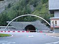 Montblanský tunel, vjezd z italské strany
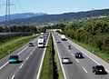 E25 ve Švýcarsku
 Trasa E25 na území Nizozemska
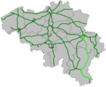 (c) LimoWreck, CC BY-SA 3.0Trasa E25 na území Belgie
 E25 u Eindhovenu
 E25 v Nizozemsku
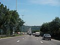 E25 poblíž Lutychu
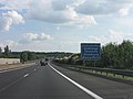 E25 v Lucembursku
 E25 na hranicích Lucemburska s Francií
 E25 v Itálii
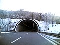 E25 v Itálii

Odkazy
Reference
V tomto článku byl použit překlad textu z článku European route E25 na anglické Wikipedii.
Související články
Externí odkazy
 Obrázky, zvuky či videa k tématu evropská silnice E25 na Wikimedia Commons
Média použitá na této stránce


Flag of Belgium.svg
This is the national flag of Belgium, according to the Official Guide to Belgian Protocol. It has a 13:15 aspect ratio, though it is rarely seen in this ratio.
Its colours are defined as Pantone black, Pantone yellow 115, and Pantone red 032; also given as CMYK 0,0,0,100; 0,8.5,79,0; and 0,94,87,0.

.svg)


International E Road Network green.png
Map generated using coastline/boundary data from World Data Bank, and locations from http://www.world-gazetteer.com/. Straight lines connect control cities, no attempt to follow the real road. Roads color has been changed to green.
Map generated using coastline/boundary data from World Data Bank, and locations from http://www.world-gazetteer.com/. Straight lines connect control cities, no attempt to follow the real road. Roads color has been changed to green.
.jpg)

_008.jpg)
_-Li%c3%a8ge.JPG)

E25Nederland.png
locatie E25 in Nederland, zelf gemaakt
locatie E25 in Nederland, zelf gemaakt
Jan Blankenbrug in A2 naast oude Lekbrug.jpg
Autor: Joop van Houdt, Licence: Attribution
Links de Jan Blankenbrug over de Lek, in de A2 tussen Vianen en Nieuwegein; rechts de oude Lekbrug.
Autor: Joop van Houdt, Licence: Attribution
Links de Jan Blankenbrug over de Lek, in de A2 tussen Vianen en Nieuwegein; rechts de oude Lekbrug.

E25Maastricht.JPG
Autor: Rossano, Licence: CC BY-SA 3.0
Autoroute E25 à la frontière entre les Pays-Bas et la Belgique
Autor: Rossano, Licence: CC BY-SA 3.0
Autoroute E25 à la frontière entre les Pays-Bas et la Belgique

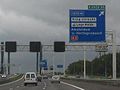
A12-E25.JPG
Autor: M.Minderhoud, Licence: CC BY-SA 3.0
roadsign E25 on A12 motorway near Utrecht (Netherlands), july 2005
Autor: M.Minderhoud, Licence: CC BY-SA 3.0
roadsign E25 on A12 motorway near Utrecht (Netherlands), july 2005

Tunnel du mont-blanc coté italien.jpg
Autor: Photo prise par François Trazzi, Licence: CC BY-SA 3.0
Entrata del tunnel del Monte Bianco, lato italiano
Autor: Photo prise par François Trazzi, Licence: CC BY-SA 3.0
Entrata del tunnel del Monte Bianco, lato italiano


AutorouteSuisseA1.jpeg
Autor: Marc Mongenet, Licence: CC BY 2.5
Swiss highway A1 in Féchy, Vaud, Switzerland.
Autor: Marc Mongenet, Licence: CC BY 2.5
Swiss highway A1 in Féchy, Vaud, Switzerland.