Filippoi
| Filippoi Φίλιπποι | |
|---|---|
| Poloha | |
| Souřadnice | 41°1′27″ s. š., 24°20′20″ v. d. |
| Nadmořská výška | 78 m n. m. |
| Stát | |
| Kraj | Východní Makedonie a Thrákie |
| Regionální jednotka | Kavala |
 (c) Lencer, CC BY-SA 3.0 Filippoi | |
| Rozloha a obyvatelstvo | |
| Počet obyvatel | 11 711 (2001) |
| Světové dědictví UNESCO | |
| Název lokality | Archeologická lokalita Filippi |
| Typ | kulturní dědictví |
| Kritérium | iii, iv |
| Odkaz | 1517 (anglicky) |
| Zařazení | 2016 (40. zasedání) |
| Některá data mohou pocházet z datové položky. | |
Filippoi (řecky Φίλιπποι, Philippi) je sídelní jednotka v Řecku, která se nachází ve východní Makedonii. Je součástí obce Kavala a v roce 2011 zde žilo 11 711 obyvatel. Toto město v současnosti bez většího významu se rozkládá na rozsáhlých ruinách antického města Filippi, které vzniklo při těžbě zlata v pohoří Pangaion. Zdejší starověká archeologická lokalita byla v roce 2016 zapsána na seznam světového kulturního dědictví UNESCO.
Historie
Své jméno město získalo po Filipu II. Makedonském, který jej na čas ovládl v roce 366 př. n. l. Nejvíce jej však proslavila bitva u Filipp (v roce 42 př. n. l.), v níž Octavianus s Antoniem porazili Caesarovy vrahy Cassia a Bruta. Později bylo město osídleno římskými vojenskými vysloužilci a zcela pořímštěno. Jeho význam ještě umocňovala poloha při „transbalkánské“ silnici Via Egnatia.
Památky
Pozůstatky antického města jsou impozantní a nacházejí se po obou stranách silnice via Egnatia, která dosud slouží svému účelu. Zbytky fóra jsou obklopeny veřejnými budovami, několika chrámy a řeckým divadlem.
- Starověké řecké divadlo pochází z roku 357 př. n. l. Bylo obnoveno v roce 1957 a každoročně se zde pořádá festival, který je nejvýznamnější kulturní akcí města.
- Osmiboký chrám pochází z doby kolem roku 400 n. l. a je zde i několik pozdějších bazilik. Nejvýznamnější jsou ruiny baziliky B, mohutné stavby vybudované po vzoru chrámu sv. Sofie v Konstantinopoli někdy kolem roku 560 n. l.
- Několik památek připomíná pobyt apoštola Pavla, který zde v roce 51 n. l. založil první křesťanskou komunitu na evropském kontinentu. Zvláštní půvab má novodobý kostelík Agia Lýdia severně od Filippoi, který leží poblíž potoka, kde sv. Pavel křtil první křesťany. Místo je opatřeno malým stavidlem a je stále používané po pravoslavném způsobu.
Fotogalerie
 Bazilika B
 Amfiteátr
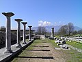 Fórum
Fórum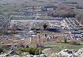 Centrum antického města
Externí odkazy
Média použitá na této stránce

(c) Lencer, CC BY-SA 3.0
Location map of Greece
Equirectangular projection, N/S stretching 120 %. Geographic limits of the map:
- N: 42.0° N
- S: 34.6° N
- W: 19.1° E
- E: 29.9° E
.jpg)
Autor: Carole Raddato from FRANKFURT, Germany, Licence: CC BY-SA 2.0
The Forum, Philippi
.jpg)
Autor: Carole Raddato from FRANKFURT, Germany, Licence: CC BY-SA 2.0
In the VIth century the inhabitants of Philippi embarked on the construction of an imposing basilica on the site of the town's palaestra; the size of the planned building clearly exceeded the needs of the town, thus indicating that Philippi attracted many pilgrims.
There is uncertainty among archaeologists whether the gigantic pillars of the basilica ever supported a dome; in 547 the so-called Justinian plague devastated the countries of the Mediterranean basin and in the early VIIth century an earthquake struck the region of Philippi; these two catastrophic events could have halted the completion of the basilica.
The decoration of the basilica moved away from classic patterns; all representations of human beings and animals were banished and even the acanthus leaves of Corinthian capitals were depicted in an almost symbolic way; this type of "combed" capitals can be observed also at many Byzantine locations in Syria of the same period.
The basilica was at the centre of a complex of buildings which included a chapel reserved to the bishop and a baptistery; the whole complex was built with materials taken from ancient monuments, but the stones were completely reworked in order to eliminate all references to gods, human beings and animals.
Autor: No machine-readable author provided. Marsyas assumed (based on copyright claims)., Licence: CC BY-SA 3.0
Philippi's forum and basilica B seen from the acropolis.
.jpg)
Autor: Carole Raddato from FRANKFURT, Germany, Licence: CC BY-SA 2.0
The ancient Theatre of Philippi is a remarkable and important monument. It is located at the foot of the acropolis and it is supported on the eastern wall of the city of Philippi. Even though it has undergone many changes over the centuries and some interventions it still preserves many of its original elements.
The first phase of the theatre dates back in the reign of Philip II in 356 BC. At that time the orchestra was u-shaped.
During Roman colonization changes were made to the theater in order to become suitable for the requirements of the new shows. The orchestra was floored with marble slabs and a high wall was built to protect the spectators during beast fights. Eventually in the 3rd Century A.D. the Theatre becomes an arena for beast fights.
During the Christian times the habits and morals of the people changed so the theater was abandoned.
Nowadays, many parts of the theatre are saved untouched still many restoration works are done so the annual Philippi Festival can take place.