Galen (kráter)
| Kráter Galen | |
|---|---|
 | |
| Souřadnice na Měsíci | |
| Selenografická šířka | 21,9° S |
| Selenografická délka | 5,0° V |
| Další údaje | |
| Typ kráteru | jednoduchý |
| Průměr kráteru | 10 km [1] |
| Hloubka | 1,6 km |
| Colongitudo | 355° |
| Eponym | Galén |

Galen je nevelký impaktní kráter nacházející se nedaleko východního úpatí pohoří Montes Apenninus (Apeniny) na přivrácené straně Měsíce. Má průměr 10 km, pojmenován je podle starořeckého lékaře Galéna.[1][2] Má přibližně kruhový tvar. Než jej Mezinárodní astronomická unie v roce 1973 přejmenovala, nesl název Aratus A.[1]
Severoseverozápadně leží kráter Aratus, západně větší Conon. Jihovýchodně se z terénu zvedá pohoří Montes Haemus, za nímž se rozprostírá plocha Mare Serenitatis (Moře jasu).
Odkazy
Reference
- ↑ a b c Antonín Rükl: Atlas Měsíce, druhé české vydání, Aventinum (Praha 2012), kapitola Conon, str. 70, č. mapového listu 22, ISBN 978-80-7151-269-1
- ↑ Crater Galen on Moon Gazetteer of Planetary Nomenclature, IAU, USGS, NASA (anglicky)
Literatura
- RÜKL, Antonín. Atlas Měsíce. 2. vyd. Praha: Aventinum, 2012. ISBN 978-80-7151-269-1.
Externí odkazy
 Obrázky, zvuky či videa k tématu Galen na Wikimedia Commons
 - Kráter Galen Archivováno 30. 5. 2018 na Wayback Machine., Moon-Wikispaces.com (anglicky)
- LAC 41, mapa 1:1 000 000 (Lambertova projekce)
Média použitá na této stránce
cylindrical map projection of the Moon. The Moon's whole surface was mapped by the Clementine spacecraft in 1994, here North is at the top. The dark floor of crater Plato is at the middle top above Mare Imbrium, while the bright floor and rays of crater Tycho is near the middle bottom below Mare Imbrium. Mare Procellarum is at the near left, and Mare Tranquillitatis is just right of centre and Mare Crisium is at the near right. The far left and far right show the contrast of the mostly cratered farside with small isolated mare.
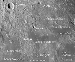
Craters Conon and Yangel', Lacus Felicitatis, Lacus Odii, Sinus Fidei and Lacus Doloris (detail of LRO - WAC global moon mosaic)
LO-IV-102H


