Gohrisch (hora)
| Gohrisch | |
|---|---|
.jpg) Pohled z Papststeinu na Gohrisch | |
| Vrchol | 447,8 m n. m. |
| Poloha | |
| Stát | |
| Pohoří | Děčínská vrchovina |
| Souřadnice | 50°54′4″ s. š., 14°6′44″ v. d. |
 Gohrisch | |
| Typ | stolová hora |
| Hornina | pískovec |
| Povodí | Labe |
| Některá data mohou pocházet z datové položky. | |
Gohrisch (nesprávně též Gohrischstein) je 447,8 m vysoká stolová hora v levobřežním Saském Švýcarsku v Sasku na území obce Gohrisch.
Stolová hora Gohrisch leží asi čtyři kilometry jihovýchodně od pevnosti Königstein a asi čtyři kilometry jižně od města Bad Schandau. V těsné blízkosti se nalézají další stolové hory Papststein, Kleinhennersdorfer Stein a Laasensteine. Na vrcholu stolové hory se nalézá přístřešek. Nachází se na území Chráněné krajinné oblasti Saské Švýcarsko.
Dějiny
Název hory pochází ze starosrbského slova Gora značícího kopec, horu. První zmínka o stolové hoře Gohrisch pochází z roku 1496, během třicetileté války sloužily zdejší četné jeskyně a skály jako krátkodobý úkryt místního obyvatelstva. V roce 1869 byl vybudován na vrcholu hostinec.
Galerie

Východní přístup

Západní přístup
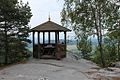
Přístřešek

Pohled ze západní vyhlídky (Wetterfahnenaussicht)
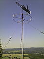
Korouhvička v roce 1985
Literatura
- Gebiet Königstein, Sächsische Schweiz (= Werte der deutschen Heimat. Band 1). 1. Auflage. Akademie Verlag, Berlin 1957.
- Peter Rölke: Wander- und Naturführer Sächsische Schweiz. Band 2 Vordere und Südliche Sächsische Schweiz. Berg- und Naturverlag Rölke, Dresden 2013, ISBN 978-3-934514-09-6
- Klaus Schneider: Der Gohrischstein in der Literatur des 18. und 19. Jahrhunderts. in: Arbeitskreis Sächsische Schweiz im Landesverein Sächsischer Heimatschutz, Mitteilungsheft 12, Pirna 2013, S. 1–43
- Bernd Ullrich, Dieter Kutschke: Historische und Mineralogische Aspekte des Bergbauversuchs am Gohrisch („Specksteinstollen“) im Elbsandsteingebirge (Sachsen). in: Geologica Saxonica 52/53(2007), S. 69–90 (Digitalisat; PDF; 1,8 MB)
Externí odkazy
- Website der Gemeinde Gohrisch
- Die touristische Erschließung des Gohrischsteins
- Fotos
 Obrázky, zvuky či videa k tématu Gohrisch na Wikimedia Commons
Média použitá na této stránce


This is a solid red equilateral triangle, which can symbolize or indicate many things, including the the symbol for fire in the books by Franz Bardon.
Autor: Norbert Kaiser, Licence: CC BY-SA 3.0
Saxon Switzerland: The Gohrisch (440 metres) seen from the Papststein.
.jpg)
Autor: Norbert Kaiser, Licence: CC BY-SA 3.0
Saxon Switzerland: eastern way on top of the Gohrisch (440 metres).
_2014.jpg)
Autor: Cmuelle8, Licence: CC0
Wetterfahne auf dem Gohrisch
Autor: Grundkarte TUBS, Relief Alexrk2, Licence: CC BY-SA 3.0
Physical Location map Saxony, Germany. Geographic limits of the map:
.jpg)
Autor: Norbert Kaiser, Licence: CC BY-SA 3.0
Saxon Switzerland: weather vane from 1985 on top of the Gohrisch (440 metres).
.jpg)
Autor: Norbert Kaiser, Licence: CC BY-SA 3.0
Saxon Switzerland: western way on top of the Gohrisch (440 metres).
.jpg)
Autor: Norbert Kaiser, Licence: CC BY-SA 3.0
Saxon Switzerland: small hut (built 1998) on top of the Gohrisch (440 metres).