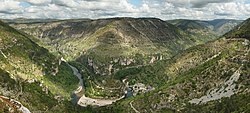
Gorges du Tarn
| Gorges du Tarn | |
|---|---|
 Soutěska v oblasti Saint-Chély-du-Tarn | |
| Základní informace | |
| Světadíl | Evropa |
| Pohoří | Francouzské středohoří |
| Průjezdnost | silnice D907bis |
| Jihozápadní část | |
| Stát | |
| Département | Lozère |
| Povodí | Tarn |
| Severovýchodní část | |
| {{{pojem vyššího celku2}}} | Aveyron |
| Poloha | |
| Souřadnice | 44°21′18″ s. š., 3°33′42″ v. d. |
| Některá data mohou pocházet z datové položky. | |
Gorges du Tarn je kaňon hluboký místy až 500 m vytvořený řekou Tarn. Toto údolí od sebe odděluje vápencové plošiny Causses Méjean a Causses Sauveterre. Největší část údolí se nalézá ve francouzském departementu Lozère, ale zasahuje částečně i do departementu Aveyron mezi městy Quezac a Le Rozier v délce cca 53 km.
Odkazy
Reference
V tomto článku byl použit překlad textu z článku Gorges du Tarn na anglické Wikipedii.
Související články
Externí odkazy
 Obrázky, zvuky či videa k tématu Gorges du Tarn na Wikimedia Commons
 - Gorges du Tarn na www.dangerousroads.org (anglicky)
Média použitá na této stránce
Autor: Benh LIEU SONG, Licence: CC BY-SA 3.0
Tarn gorge, taken near the point sublime (which can be seen on the far left). This picture features the Baumes cirque on the left, and the Causse Méjéan plateau on the center. It is a mosaic of 8 photos (2x4) taken with a Canon EOS 400D camera and a EF-S 17-55mm IS f/2.8 lens set at 17mm. Exposition 1/320s, f/8.0 and ISO 100. Resulting horizontal field of view is 248°. Stitching was done with Hugin OS X and Enblend 3.
Autor: Benh LIEU SONG, Licence: CC BY-SA 3.0
View over the cirque of Pougnadoires and Saint-Chély-du-Tarn village, in the Tarn Gorges, from the cirque of Saint-Chély. This picture features the road D 907bis which goes alongside the Tarn river all along the gorges. This picture is a mosaic of 14 pictures taken at 43mm, f/8.0, 1/250s and ISO 100. Stitching was done with Hugin and Enblend. Resulting hozirontal FOV is 118°.
Autor: Eric Gaba (Sting - fr:Sting), Licence: CC BY-SA 4.0
Blank physical map of metropolitan France for geo-location purpose.
Scale : 1:14 816 000 (accuracy : about 3,7 km) for the bathymetry. More maps of France, view → Commons Atlas of France.


