Grand Bahama
| Grand Bahama | |
|---|---|
 Západní a střední část ostrova na satelitním snímku. V dolní části oblouku je vidět město Freeport. | |
 Grand Bahama | |
| Lokalizace | Atlantský oceán |
| Stát | |
| Topografie | |
| Rozloha | 1 373 km² |
| Zeměpisné souřadnice | 26°39′ s. š., 78°19′ z. d. |
| Nejvyšší vrchol | (12 m n. m.) |
| Osídlení | |
| Počet obyvatel | 51 756 (2010) |
| Hustota zalidnění | 37,7 obyv./km² |
| Některá data mohou pocházet z datové položky. | |
Grand Bahama je nejsevernější ostrov souostroví Bahamy, vzdálený jen 103 kilometrů od Palm Beach na Floridě. S rozlohou 1373 km² je Grand Bahama čtvrtým největším ostrovem celého bahamského souostroví s přibližně 700 ostrovy. Ostrov je orientován východozápadně, na délku má 153 kilometrů, a v nejširším místě je zhruba 24 kilometrů široký. Největším sídlem je město Freeport. Administrativně ostrov sestává z Freeportské smluvní oblasti (Freeport Bonded Zone) a okresů East Grand Bahama a West Grand Bahama. Začátkem září 2019 byl ostrov těžce zasažen hurikánem Dorian, který zde zničil téměř polovinu domů.

Galerie

Přístav ve Freeportu
 (c) Pietro Valocchi, CC BY 3.0
Pláž Taino Beach
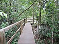
Národní park Lucayan
Externí odkazy
 Obrázky, zvuky či videa k tématu Velká Bahama na Wikimedia Commons
Média použitá na této stránce


.jpg)
This satellite image of Grand Bahama has been cropped from an image of Florida, Cuba, and the Bahamas.
"Underwater features are actually more striking than surface features in this Moderate Resolution Imaging Spectroradiometer (MODIS) image, acquired on January 24, 2004, by NASA’s Terra satellite. The Great Bahama Bank and Little Bahama Bank are a brilliant blue in contrast to the black of the surrounding ocean. The Banks are shallow coral reefs that reflect light through the ocean, giving it a bright blue color. The ocean becomes suddenly deep on the western edge of the Grand Bahama Bank, and here it becomes an inky black. Coral reefs are also visible around the Florida Keys and in the Golfo de Batabanóuth of Cuba. Near land, sediment may also be coloring the water. Like coral reefs, sediment reflects light through the water, giving it a bright color. A few fires were burning when this image was acquired, and they have been marked with red dots."
Description at NASA's Visible Earth website
Grand Bahama Island, Bahamas - June 1998.

Autor: ArnoldReinhold, Licence: CC BY 4.0
Tug and barge in Freeport Harbor, the Bahamas, with container terminal in background. Viewed from the deck of the Carnival Fantasy.