Grandes Jorasses
| Grandes Jorasses | |
|---|---|
 Grandes Jorasses | |
| Vrchol | 4208 m n. m. |
| Prominence | 843 m |
| Seznamy | Alpské čtyřtisícovky |
| Poloha | |
| Světadíl | Evropa |
| Stát | |
| Pohoří | Montblanský masiv, Grajské Alpy, Západní Alpy |
| Souřadnice | 45°52′ s. š., 6°59′ v. d. |
| Prvovýstup | 30. červen 1868, Horace Walker, Melchior Anderegg, Johann Jaun a Julien Grange |
| Některá data mohou pocházet z datové položky. | |
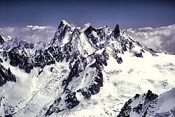
Grandes Jorasses (4208 m n. m.) je hora v Montblanském masivu v Grajských Alpách. Leží na hranici mezi Francií (region Rhône-Alpes) a Itálií (region Valle d'Aosta). Hřeben Grandes Jorasses probíhá od sedla Col des Hirondelles (3491 m) na východě po sedlo Col des Grandes Jorasses (3870 m) na západě. Na západ od sedla Col des Grandes Jorasses se nachází hřeben Rochefort.
Grandes Jorasses má tyto vrcholky (od východu na západ):
- Pointe Walker (4208 m n. m.) - nejvyšší vrchol, zakončení hřebene Hirondelles
- Pointe Whymper (4104 m n. m.)
- Pointe Croz (4110 m n. m.)
- Pointe Helene (4045 m n. m.)
- Pointe Margarita (4065 m n. m.)
- Pointe Young (3996 m n. m.)
Severní stěna Grandes Jorasses nad ledovcem Glacier de Leschaux je vysoká 1200 m. Klasickou cestou z této strany je Walkerův pilíř (Cassin/Esposito/Tizzoni, 1938, TD+/ED1, IV, 5c/6a, A1, 1200 m).
Walkerův pilíř na Grandes Jorasses, severní stěna Eigeru a severní stěna Matterhornu tvoří tzv. "Alpský triptych" (první cesty nejnáročnějšími stěnami Alp).
Na vrchol jako první vystoupili 30. června 1868 Horace Walker, Melchior Anderegg, Johann Jaun a Julien Grange
Reference
V tomto článku byl použit překlad textu z článku Grandes Jorasses na polské Wikipedii.
Externí odkazy
 Obrázky, zvuky či videa k tématu Grandes Jorasses na Wikimedia Commons
  Galerie Grandes Jorasses na Wikimedia Commons
- Grandes Jorasses na SummitPost.org
Média použitá na této stránce
This is a solid red equilateral triangle, which can symbolize or indicate many things, including the the symbol for fire in the books by Franz Bardon.
The Grandes Jorasses (4208 m) and Dent du Geant (4103 m), near Chamonix, France. The Grandes Jorasses is the (apparent) highest of the peaks in the picture, one third of the way across the picture from the left hand side. The Dent du Geant (4103 m) is the dark “tooth” on the right of the range (about one third in from the right of the picture). I believe the central dark peak is Mont Mallet (3989 m) and the ill-defined “peak” between Mont Mallet and the Dent du Geant is the Aiguille de Rochefort.


