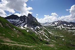
Große Wildgrubenspitze
| Große Wildgrubenspitze | |
|---|---|
 Große Wildgrubenspitze (vlevo) a Roggalspitze | |
| Vrchol | 2753 m n. m. |
| Poznámka | nejvyšší hora pohoří Lechquellengebirge |
| Poloha | |
| Světadíl | Evropa |
| Stát | |
| Pohoří | Alpy / Východní Alpy / Severní vápencové Alpy / Lechquellengebirge |
| Souřadnice | 47°9′53″ s. š., 10°7′34″ v. d. |
| Některá data mohou pocházet z datové položky. | |
Große Wildgrubenspitze (též Untere Wildgrubenspitze, 2753 m n. m.) je nejvyšší hora pohoří Lechquellengebirge. Nachází se na území okresu Bludenz v rakouské spolkové zemi Vorarlbersko asi 3 km západně od vesnice Zürs. Na vrchol je možné vystoupit od chaty Ravensburger Hütte.
Reference
V tomto článku byl použit překlad textu z článku Große Wildgrubenspitze na polské Wikipedii.
Externí odkazy
 Obrázky, zvuky či videa k tématu Große Wildgrubenspitze na Wikimedia Commons
 - Große Wildgrubenspitze na Peakbagger.com
- Große Wildgrubenspitze na Hikr.org
Média použitá na této stránce
This is a solid red equilateral triangle, which can symbolize or indicate many things, including the the symbol for fire in the books by Franz Bardon.
Autor: Josef Saurwein, Licence: CC BY-SA 3.0
Blick auf die Untere Wildgrubenspitze (links, 2.753 m), rechts daneben die Roggalspitze (2.673 m). Im Hintergrund sind die Pflunspitzen (2912 m) und die Östliche Eisentaler Spitze (2753 m). Zwischen diesen beiden in der Ferne der Große und Kleine Piz Buin. Rechts die Ronspitze (2498m).
Autor: Rosso Robot, Licence: CC BY-SA 3.0
Location map of Vorarlberg
Equirectangular projection. Geographic limits of the map:
- N: 47.62 N
- S: 46.82 N
- W: 9.45 E
- E: 10.3 E


