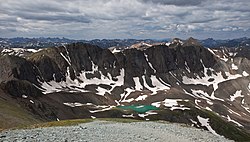
Handies Peak
| Handies Peak | |
|---|---|
 Handies Peak | |
| Vrchol | 4 282 m n. m. |
| Prominence | 576 m |
| Izolace | 18 km |
| Poloha | |
| Světadíl | Severní Amerika |
| Stát | |
| Pohoří | San Juan Mountains, Skalnaté hory |
| Souřadnice | 37°54′47″ s. š., 107°30′16″ z. d. |
| Některá data mohou pocházet z datové položky. | |
Handies Peak je s nadmořskou výškou 4 282 metrů jeden z nejvyšších vrcholů pohoří San Juan Mountains, která jsou součástí jižních Skalnatých hor. Náleží také do první padesátky nejvyšších hor ve Spojených státech amerických.[1] Handies Peak leží ve střední části pohoří San Juan Mountains,[2] v Hinsdale County, na jihozápadě Colorada.[3][4]
Reference
- ↑ Handies Peak, Colorado [online]. Peakbagger.com, 1987 [cit. 2017-12-28]. Dostupné online. (anglicky)
- ↑ Utah, Nevada, Colorado Travel Map / 1:800 000. Mnichov: Kunth
- ↑ Merriam-Webster's Geographical Dictionary. 3. vyd. Springfield, Massachusetts, U. S. A.: Merriam-Webster, Incorporporated, Publishers, 1997. 1361 s. Dostupné online. ISBN 0-87779-546-0. S. 468. (anglicky)
- ↑ Handies Peak [online]. United States Geological Survey, 1978 [cit. 2021-12-28]. Dostupné v archivu pořízeném dne 2021-03-02. (anglicky)
Externí odkazy
 Obrázky, zvuky či videa k tématu Handies Peak na Wikimedia Commons
Handies Peak, 14ers.com (anglicky)
Média použitá na této stránce
This is a solid red equilateral triangle, which can symbolize or indicate many things, including the the symbol for fire in the books by Franz Bardon.
The scenic quality of the Handies Peak Wilderness Study Area in Colorado is outstanding due to the interaction of mountainous landforms; multi-colored rock strata; diverse vegetation; and vast, open vistas. Handies Peak itself rises 14,048 feet (4,282 m) over the area and is the highest point of land managed by the Bureau of Land Management outside of Alaska. This WSA also hosts 12 other peaks that rise over 130,000 feet (40,000 m), three major canyons, numerous small drainages, glacial cirques and three alpine lakes. The geomorphology shows a variety of volcanic, glacial and Precambrian formations. A rock glacier formation is also located at the head of American Basin.
Vegetation consists mainly of mixed sprice, fir, aspen, alpine grasses, sedges, and forbs. Fauna includes elk, deer, black bear, various small mammals, bighorn sheep, and very rarely, mountain goats.
Recreation activities include hiking, backpacking, camping, mountain climbing, and photography. Please note that though unconfined recreation is encouraged in WSAs, specific types of recreation may be barred from a specific area to prevent degradation of natural conditions.
Plan your trip: www.blm.gov/co/st/en/BLM_Programs/national_landscape/wild...
Photo: Bob Wick, BLM CaliforniaAutor: SANtosito, Licence: CC BY-SA 4.0
Location map of Colorado, USA
Geographic limits of the map:
- N: 41.2° N
- S: 36.8° N
- W: 109.3° W
- E: 101.8° W


