Houtribdijk


Houtribdijk (též pod názvy Markerwaarddijk, Markermeerdijk či Dijk Enkhuizen-Lelystad) je hráz v Nizozemsku, která od sebe odděluje vody jezer IJsselmeer a Markermeer a je dlouhá 28 km. Její výstavba začala roku 1963, dokončena byla v roce 1975. Po koruně hráze vede silnice spojující města Enkhuizen v Severním Holandsku a Lelystad v Flevolandu.
Hráz je součástí obrovského vodohospodářského projektu Zuiderzeewerken, jehož cílem bylo zahrazení mořského zálivu Zuiderzee a následné vysušení a zapoldrování nově vzniklého jezera. Takto vznikly poldry Noordoostpolder, Wieringermeer, Oostelijk Flevoland a Zuidelijk Flevoland. Prostor jezera Markermeer byl původně též určen k výstavbě pátého poldru Markerwaard, z jehož realizace však sešlo.
Fotogalerie
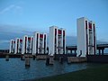
část hráze v blízkosti města Lelystad (propojení jezer Maakermeer a IJsselmeer)
část hráze s akvaduktem u města Enkhuizen

mapa projektu Zuiderzeewerken s poldrem Markerwaard
Externí odkazy
 Obrázky, zvuky či videa k tématu Houtribdijk na Wikimedia Commons
Média použitá na této stránce

(c) M.P. Tillema na projektu Wikipedie v jazyce nizozemština, CC BY 2.5 nl
This is an image of a municipal monument in Lelystad with number

Autor: Copernicus Sentinel-2, ESA, Licence: CC BY-SA 3.0 igo
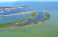
A satellite photo of the Houtribdijk, The Netherlands, 30 June 2018. To the north of the Houtribdijk is the IJsselmeer, to the south is the Markermeer. Sensor: MSI on Sentinel-2A. Resolution: 10m. RGB Composites: True color, Band 4-3-2.
Autor: Original von Scipius, überarbeitet von Voyager, Licence: CC BY-SA 3.0
Map of the Zuiderzee Works in the Netherlands.

Design for the Closure of the Zuiderzee. This sketch design by Cornelis Lely (1891) was broadly the basis of the closure and partial reclamation of the Zuiderzee, as carried out by the Dienst Werken aan de Zuiderzee. However, the construction of the Afsluitdijk did not start until 1918. At the bottom of the map, the planned sequence of the land reclamation works is stated. Design for Closure of the Zuiderzee across Wieringen with partial embankment within that closure. - Scale 1:200,000. - [Zwolle : Heirs J.J. Tyll, 1892]. - 1 map: color lithography; 88x60cm. - Title top left. - Scale indication and scale stick of 20 Kilometers [= 10 cm] below the title. - North up. - Bottom right an explanation of characters in a frame. - Below outside the frame 12 schematic figures representing the sequence of drying. - In the new polders, the size in HA and the water level are indicated.