Hurikán Bertha (2008)
| Hurikán Bertha | |||||||||||||||
|---|---|---|---|---|---|---|---|---|---|---|---|---|---|---|---|
 Hurikán Berta | |||||||||||||||
| Informace | |||||||||||||||
| Kategorie | |||||||||||||||
| Zformování | 3. července 2008 | ||||||||||||||
| Rozptýlení | 20. července 2008 | ||||||||||||||
| Nejnižší tlak | 952 mb/hPa | ||||||||||||||
| Nejvyšší rychlost | 1 min. průměr 205 km/h | ||||||||||||||
| Škody | minimální | ||||||||||||||
| Oběti | 3 přímé | ||||||||||||||
| Postižené oblasti | Bermudy, Delaware, Severní Karolína, New Jersey, Island | ||||||||||||||
| Trasa bouře | |||||||||||||||
 | |||||||||||||||
| Součást | |||||||||||||||
| atlantické hurikánové sezóny 2008 | |||||||||||||||
| Některá data mohou pocházet z datové položky. | |||||||||||||||
Hurikán Bertha byl druhou bouří Atlantické hurikánové sezóny 2008 a měl hned po hurikánu Ike nejvíce naakumulované energie. Zformoval se 3. července nedaleko Kapverd. Zanikl 20. července uprostřed Atlantiku nedaleko 51° s. š.
Základní údaje
- Dosažená kategorie: Hurikán 3. kategorie
- Datum vzniku: 3. července 2008 - vznik tlakové níže, (1. července - vznik tropické vlny)
- Datum zániku: 20. července 2008 - přeměna na tlakovou níži mírného pásu (dále postup na Island).
- Min. tlak: 948 hPa
- Max. rychlost větru (1 min. průměr): 205 km/h
- Zasažené oblasti: Bermudy, New Jersey, (Island)
Postup

Hurikán Bertha vznikl 1. července 2008 jako tropická vlna mezi Kapverdami a pobřežím Afriky a postupoval na západ. 3. července z tohoto systému vznikla tlaková níže 2, která záhy zesílila na tropickou bouři Bertha. Při svém postupu na západoseverozápad bouře postupně sílila a 7. července zesílila do stádia hurikánu 1. kategorie. Ještě toho večera (SEČ) však Bertha rychle zesílila na hurikán 3. kategorie a změnila svůj směr pohybu na severozápadní. Během dopoledne 8. července (SEČ) postupovala Bertha jako hurikán 3. kategorie dále na severozápad. V této době dosahoval tlak vzduchu ve středu bouře nejnižších hodnot a foukal v ní nejsilnější vítr. Během odpoledne (SEČ) však Bertha opět poměrně rychle zeslábla na hurikán 1. kategorie. 9. července odpoledne Bertha opět zesílila, už jen však na Hurikán 2. kategorie a dále postupovala na severozápad. Odpoledne 10. července (SEČ) Bertha opět zeslábla na hurikán 1. kategorie. 12. července Bertha velmi zpomalila svůj postup a 13. července zeslábla na Tropickou bouři a stočila svůj směr postupu na severoseverozápad. Poté, co Bertha 14. července přešla přes Bermudy se stočila na severoseverovýchod. 16. července se Bertha ve svém postupu prudce stočila na jihovýchod a poněkud zrychlila svůj postup. 17. července se bouře stočila na východ a 18. července na severovýchod. Brzy ráno 19. července (SEČ) bouře opět zesílila na hurikán 1. kategorie a výrazně zrychlila svůj postup na severozápad. Ráno 20. července Bertha opět zeslábla na tentokrát již subtropickou bouři a odpoledne se přeměnila na tlakovou níži mírného pásu a během několika dalších dní se přesunula nad Island.
Škody
Přestože byla Bertha poměrně silný hurikán, nezpůsobila díky své dráze postupu žádné výrazné škody, přesto však v jejím důsledku zřejmě zahynuli 3 lidé.
Obrázky
Hurikán Bertha 7. července

Hurikán Bertha 9. července

Hurikán Bertha 10. července

Hurikán Bertha 12. července

Tropická bouře Bertha 14. července

Hurikán Bertha 18. července
Odkazy
Externí odkazy
 Obrázky, zvuky či videa k tématu Hurikán Bertha na Wikimedia Commons
 - www.stormpulse.com
Média použitá na této stránce
On July 3, a tropical wave (a migratory, wavelike disturbance of the tropical easterlies) off the western coast of Africa strengthened into a circular pattern of intensifying clouds, forming Tropical Storm Bertha. This natural-color image, obtained by the Moderate Resolution Imaging Spectroradiometer (MODIS) on NASA’s Terra satellite shows Bertha in its early stages, south of the Cape Verde Islands. Storms that form in this region are known as Cape Verde storms, and they typically are first observed forming in August or September, though a Cape Verde storm as early as July is not particularly unusual.
The storm system shows the nascent spiraling shape of a developing cyclone. Within days, Tropical Storm Bertha was halfway across the Atlantic Ocean, intensifying to become a hurricane as it traveled over warm ocean waters. According to the National Hurricane Center, as of July 8, Bertha was a Category 2 strength hurricane, having peaked earlier at Category 3. Forecasts at that time showed Bertha arcing northward towards Bermuda, though forecasters were not expecting the hurricane to directly cross the island.
Bertha was the first hurricane of the 2008 Atlantic storm season. Usually, the first hurricane of a season forms by mid-August; in 2007, the first hurricane was Dean, which formed on August 16. However, it is not unprecedented to have a first hurricane this early in the season. In 1996, another storm formed to become a hurricane on July 7. It, too, was named Bertha. Unless they are retired, storm names are reused every six years.Track map of Hurricane Bertha of the 2008 Atlantic hurricane season. The points show the location of the storm at 6-hour intervals. The colour represents the storm's maximum sustained wind speeds as classified in the Saffir–Simpson scale (see below), and the shape of the data points represent the nature of the storm, according to the legend below.
Storm type

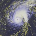
Hurricane Bertha on July 7.

Hurricane Bertha as a Category One Hurricane on July 10, 2008


Hurricane Bertha at 4:57 pm on July 12

In the overnight hours of July 6, 2008, Tropical Storm Bertha matured into the first hurricane of the 2008 Atlantic season. Far from land, the storm posed little threat, but it was record-breaking nevertheless. Since reliable records began in the 1940s, no hurricane has ever formed so far east before August 1.
This natural-color image of Hurricane Bertha was captured by the Moderate Resolution Imaging Spectroradiometer (MODIS) on NASA’s Terra satellite on July 9, 2008, at 14:45 UTC (10:45 a.m. Eastern Daylight Time). Shortly after, the National Hurricane Center estimated that Bertha was a Category 1 storm, with maximum sustained wind speeds of 75 miles per hour. Bertha was compact when MODIS observed it, a small ball of clouds with a long line of thunderstorms trailing away to the southeast. The eye of the storm had clouded over. Bertha spun up from a tropical depression that coalesced near the Cape Verde Islands in the first week of July. By the early morning hours of July 7, it had become a Category 1 hurricane, and less than 12 hours later had intensified to Category 3 status, with winds near 115 mph. Two days later, when this image was captured, the storm had weakened to Category 1, but was forecast to re-intensify.
Bertha was a “Cape Verde” storm, a tropical storm that starts near the Cape Verde Islands when a wavelike kink in the tropical easterlies over Africa ripples out over the ocean. These kinks, known as tropical waves, help start the large-scale rotation of clusters of thunderstorms that will lead to a cyclone. Early in the season, these waves are weaker, and sea surface temperatures are cooler, and so it usually takes many days for any Cape Verde storms that form to intensify into hurricanes—and all the while they are drifting west. Bertha transformed into a major hurricane very rapidly, and thus, farther east than is usual for July.
An RGB-enhanced visible image of Hurricane Bertha at Category 1 strength on 18th July.

Tropical Storm Bertha while over Bermuda. 1530Z
MODIS image of Hurricane Bertha. 1630Z