Hurikán Maria
| Hurikán Maria | |||||||||||||||
|---|---|---|---|---|---|---|---|---|---|---|---|---|---|---|---|
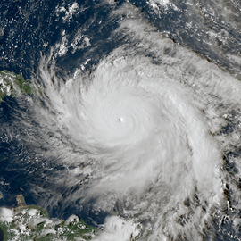
 Hurikán Maria 19. září 2017 | |||||||||||||||
| Informace | |||||||||||||||
| Kategorie | |||||||||||||||
| Zformování | 16. září 2017 | ||||||||||||||
| Rozptýlení | 3. října 2017 (mimotropická po 30. září 2017) | ||||||||||||||
| Nejnižší tlak | 908 mb/hPa | ||||||||||||||
| Nejvyšší rychlost | 1 min. průměr 280 km/h | ||||||||||||||
| Škody | 91,61 miliard USD | ||||||||||||||
| Oběti | >3 000[1] | ||||||||||||||
| Postižené oblasti | Malé Antily, Portoriko, Dominikánská republika, Bahamy | ||||||||||||||
| Trasa bouře | |||||||||||||||
 | |||||||||||||||
| Součást | |||||||||||||||
| atlantické hurikánové sezóny 2017 | |||||||||||||||
| Některá data mohou pocházet z datové položky. | |||||||||||||||
Hurikán Maria byla desátá nejintenzivnější tropická cyklóna v Atlantském oceánu, nejničivější živelná pohroma ostrova Dominika v zaznamenané historii a nejsilnější hurikán na ostrově Portoriko od roku 1928. Šlo o sedmý hurikán neobvykle silné atlantické hurikanové sezóny roku 2017. Hurikán Maria způsobil katastrofické škody napříč severozápadním Karibikem, když se stal třetím hurikánem v řadě který zasáhl Závětrné ostrovy krátce poté co je zpustošil Hurikán Irma.
Bouře se zformovala 16. září asi 1000 kilometrů od Malých Antil, které zasáhla 18. září s intenzitou hurikánu páté kategorie.[2] Hurikán přímo zasáhl ostrov Dominika, kde poškodil většinu staveb a usmrtil nejméně 27 lidi, čímž se stal nejhorší živelnou katastrofou v dějinách této země. Po krátkém oslabení vyvolaném přechodem přes ostrov hurikán opětovně zesílil, nárazy větru dosáhly rychlosti 280 km/h a tlak v centru bouře poklesl na 908 mb/hPa. Maria se tím stala desátou nejintenzivnější tropickou cyklónou v Atlantském oceánu. Předtím, než zasáhl americké ostrovní území Portoriko, hurikán zeslábl na 4. kategorii s rychlostmi větru dosahujícími 250 km/h. Maria se i tak stala nejsilnějším hurikánem, který ostrov zasáhl od roku 1828. Na ostrově zničil elektrickou síť, přerušil komunikace a usmrtil zde nejméně 2975 lidí.[1] Prvotní odhady škod na Portoriku dosáhly 40 až 85 miliard dolarů.
27. září hurikán zasáhl oblast kolem mysu Hatteras v Severní Karolíně, kde si ale nevyžádal výraznější škody.

Oběti
| Země | Mrtvých | Pohřešovaných |
|---|---|---|
| 31 | 37 | |
| 5 | 1 | |
| 2 | 2 | |
| 1 | 2 | |
| 0 | 0 | |
| 2975 až 4645[3][4] | ? | |
| 1 | 0 | |
| 4 | 0 | |
| Celkem | 3019 až 4689 | neznámo |
Počet úmrtí na Portoriku a zprávy o tomto údaji prošly cyklem zvyšování z původních 16 obětí z 3. října 2017 a pozdějších 64 obětí, až po revizi univerzity George Washingtona téměř o rok později, z 28. srpna 2018, která dospěla k závěru, že v důsledku hurikánu zemřelo na Portoriku 2975 osob (dle dané metodiky to bylo 2658–3290 osob s pravděpodobností 95 %).[3] Studie z Harvardu, která vyšla o den později, odhaduje počet obětí na 4645, což by z Marie činilo druhý nejtragičtější hurikán v historii.[5]
Odkazy
Reference
- ↑ a b Portoriko oznámilo nový počet obětí hurikánu Maria, zemřelo 2975 lidí. iDNES.cz [online]. 2018-08-29 [cit. 2018-08-31]. Dostupné online.
- ↑ Hurikán Maria zesílil na nejvyšší stupeň a míří ke Karibiku ve stopách ničivé Irmy. Aktuálně.cz [online]. Economia, 2017-09-18 [cit. 2017-09-19]. Dostupné online.
- ↑ a b CNN, Leyla Santiago, Catherine E. Shoichet and Jason Kravarik,. Puerto Rico's new Hurricane Maria death toll is 46 times higher than the government's previous count. CNN. Dostupné online [cit. 2018-09-04].
- ↑ CNN, John D. Sutter and Leyla Santiago,. Hurricane Maria death toll may be more than 4,600 in Puerto Rico. CNN. Dostupné online [cit. 2018-09-04].
- ↑ BLAKE, ERIC S; LANDSEA, CHRISTOPHER W; GIBNEY, ETHAN J. The deadliest, costliest and most intense United States tropical cyclones from 1851 to 2010 (and other frequently requested hurricane facts) [online]. National Oceanic and Atmospheric Administration [cit. 2011-08-01]. Dostupné online.
Externí odkazy
 Obrázky, zvuky či videa k tématu Hurikán Maria na Wikimedia Commons
Média použitá na této stránce
The flag of the Dominican Republic has a centered white cross that extends to the edges. This emblem is similar to the flag design and shows a bible, a cross of gold and 6 Dominican flags. There are branches of olive and palm around the shield and above on the ribbon is the motto "Dios,Patria!, Libertad" ("God, Country, Freedom") and to amiable freedom. The blue is said to stand for liberty, red for the fire and blood of the independence struggle and the white cross symbolized that God has not forgotten his people. "Republica Dominicana". The Dominican flag was designed by Juan Pablo Duarte, father of the national Independence of Dominican Republic. The first dominican flag was sewn by a young lady named Concepción Bona, who lived across the street of El Baluarte, monument where the patriots gathered to fight for the independence, the night of February 27th, 1844. Concepción Bona was helped by her first cousin María de Jesús Pina.
The flag of the Dominican Republic has a centered white cross that extends to the edges. This emblem is similar to the flag design and shows a bible, a cross of gold and 6 Dominican flags. There are branches of olive and palm around the shield and above on the ribbon is the motto "Dios,Patria!, Libertad" ("God, Country, Freedom") and to amiable freedom. The blue is said to stand for liberty, red for the fire and blood of the independence struggle and the white cross symbolized that God has not forgotten his people. "Republica Dominicana". The Dominican flag was designed by Juan Pablo Duarte, father of the national Independence of Dominican Republic. The first dominican flag was sewn by a young lady named Concepción Bona, who lived across the street of El Baluarte, monument where the patriots gathered to fight for the independence, the night of February 27th, 1844. Concepción Bona was helped by her first cousin María de Jesús Pina.
Track map of Hurricane Maria of the 2017 Atlantic hurricane season. The points show the location of the storm at 6-hour intervals. The colour represents the storm's maximum sustained wind speeds as classified in the Saffir–Simpson scale (see below), and the shape of the data points represent the nature of the storm, according to the legend below.
Storm type
The national and official state flag of Haiti; arms obtained from File:Coat of arms of Haiti.svg. The civil flag can be found at here.
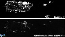
NOAA Satellites captured images of Puerto Rico after Hurricane Maria knocked out the power grid and left millions without electricity.
Hurricane Maria near peak intensity, moving north towards Puerto Rico, on September 19, 2017.


