Irsko (ostrov)
| Irsko | |
|---|---|
 Mapa Irska | |
 Irsko | |
| Stát | |
| Topografie | |
| Zeměpisné souřadnice | 53°21′4″ s. š., 7°55′16″ z. d. |
| Některá data mohou pocházet z datové položky. | |
Irsko je ostrov v Atlantském oceánu na severozápadě Evropy. Je rozlohou 84 412 km² druhým největším z Britských ostrovů a po Velké Británii a Islandu třetím největším ostrovem Evropy. Má zhruba 7,19 milionu obyvatel. Větší část ostrova (pět šestin) zaujímá Irská republika, zbylá šestina je coby Severní Irsko součástí Spojeného království Velké Británie a Severního Irska.
Irsku se také říká Smaragdový či Zelený ostrov. Latinské pojmenování pro Irsko je Hibernia.
Geografie
Povrch Irska je převážně nížinatý, zejména pak v centrálních oblastech. Hornatiny se vyskytují v blízkosti pobřeží. Nejvyšším vrcholem je Carrauntoohill (1 041 m, irsky Carrán Tuathail) v pohoří Macgillycuddy's Reeks. Mezi další významná pohoří patří: Wicklow Mountains na východě a Antrim Plateau v Severním Irsku.
V Irsku se též vyskytují četné útesy – nejznámější Moherské útesy (anglicky Cliffs of Moher) či nejvyšší Slieve League a Croaghaun.
Nejdelší řekou nejen Irska, ale i Britských ostrovů je 386 km dlouhá řeka Shannon. Na jejím toku jsou tři velká jezera (po proudu): Lough Allen, Lough Ree a Lough Derg. Největším jezerem ostrova je Lough Neagh v Severním Irsku. Ostrov si vysloužil přezdívku „Smaragdový ostrov“ díky bujné vegetaci, která je zde díky mírnému klimatu a častému jemnému dešti. Rozloha ostrova je 84 412 km2.

Irsko se rozděluje do čtyř provincií: Connacht, Leinster, Munster a Ulster, dříve též existovala provincie Meath. Dále se dělily na 32 hrabství pro administrativní potřeby Britské správy v 19. století. Šest hrabství Ulsteru zůstává pod britskou správou díky referendu z roku 1973. Zbylých 26 hrabství nyní tvoří Irskou republiku.
Nejhůře obdělávatelná půda leží v jihozápadních a západních krajích. Tyto části jsou velmi hornaté, s nádherným výhledem.
Dějiny
Historické členění

Z historického hlediska se Irsko dělí na čtyři provincie: Munster (jih Irska – patří sem hrabství Cork, Kerry, Waterford, Tipperary, Limerick a Clare), Leinster (středovýchod ostrova – hrabství Wexford, Kilkenny, Carlow, Laois (Leix), Offaly, Westmeath, Longford, Meath, Louth, Kildare, Wicklow a Dublin), Connacht (neboli Connaught – středozápad ostrova – hrabství Galway, Roscommon, Mayo, Sligo a Leitrim) a Ulster (sever ostrova – hrabství Donegal, Cavan, Monaghan, Fermanagh, Tyrone, Londonderry (Derry), Antrim, Armagh a Down). Dříve se někdy uváděla ještě pátá provincie Meath (tzv. Střední království), pod kterou spadala celá hrabství Meath a Westmeath a dále části hrabství Dublin, Cavan, Kildare, Longford, Louth a Offaly, dnes už však uvažujeme pouze čtyři výše zmíněné provincie.
K Irské republice patří celý Munster, Leinster a Connaught a tři hrabství Ulsteru (Donegal, Monaghan a Cavan), zbývajících šest hrabství tvoří Severní Irsko, které je Iry často zváno jako „six counties“.
 | Irská republika |
Galerie
 Vlajka Irské republiky – trikolóra pochází z roku 1919
 Satelitní snímek irského ostrova ve skutečných barvách
 Dublin
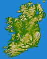 Topografická mapa Irska
Externí odkazy
Média použitá na této stránce

Zelený pruh má znázorňovat většinové katolické obyvatelsto Irska, oranžový pruh reprezentuje protestantskou menšinu a bílý pruh uprostřed znázorňuje mír a harmonii mezi nimi.


Autor: Hans-Peter Bock hpbock@avaapgh.de, Licence: CC BY 2.5
Dublin at twilight
Arms of Ireland. Blazon: Azure, a harp or stringed argent. With 14 strings shown.

Elevation data in this topographical image of Ireland were acquired by the Shuttle Radar Topography Mission on board the STS-99 flight of the Space Shuttle Endeavour, launched on 11 February 2000.
The island of Ireland comprises a large central lowland of limestone with a relief of hills surrounded by a discontinuous border of coastal mountains which vary greatly in geological structure. The mountain ridges of the south are composed of old red sandstone separated by limestone river valleys. Granite predominates in the mountains of Counties Galway, Mayo, and Donegal in the west and north-west and in Counties Down and Wicklow on the east coast, while a basalt plateau covers much of the north-east of the country. The central plain, which is broken in places by low hills, is extensively covered with glacial deposits of clay and sand. It has considerable areas of bog and numerous lakes. The island has seen at least two general glaciations and everywhere ice-smoothed rock, mountain lakes, glacial valleys and deposits of glacial sand, gravel and clay mark the passage of the ice.
Two visualisation methods were combined to produce this image: shading and colour coding of topographic height. The shade image was derived by computing topographic slope in the northwest-southeast direction, so that northwest slopes appear bright and southeast slopes appear dark. Colour coding is directly related to topographic height, with green at the lower elevations, rising through yellow and tan, to white at the highest elevations.
Elevation data used in this image were acquired by the Shuttle Radar Topography Mission on board the Space Shuttle Endeavour, launched on 11 February 2000. SRTM used the same radar instrument that comprised the Spaceborne Imaging Radar-C/X-Band Synthetic Aperture Radar (SIR-C/X-SAR) that flew twice on the Space Shuttle Endeavour in 1994. SRTM was designed to collect 3-D measurements of the Earth's surface. To collect the 3-D data, engineers added a 60-metre (approximately 200-foot) mast, installed additional C-band and X-band antennas, and improved tracking and navigation devices. The mission was a cooperative project between NASA, the National Geospatial-Intelligence Agency (NGA) of the U.S. Department of Defense and the German and Italian space agencies. It was managed by NASA's Jet Propulsion Laboratory, Pasadena, California, for NASA's Earth Science Enterprise, Washington, D.C.
Location: 53.5 degrees North latitude, 8 degrees West longitude
Orientation: North toward the top, Mercator projection

A true colour image of Ireland captured by a NASA satellite
Autor: User Morwen on en.wikipedia, Licence: CC BY-SA 3.0
Map showing the 32 en:counties of Ireland. For an SVG map based on this one, see https://commons.wikimedia.org/wiki/File:Ireland_trad_counties_blank_(numbered).svg#%7B%7Bint%3Afiledesc%7D%7D.
.svg#%7B%7Bint%3Afiledesc%7D%7D)
- 08:07, 5 February 2004 Morwen 400x499 (95970 bytes) (map)
Autor: Tentotwo, Licence: CC BY-SA 3.0
Relief location map of Atlantic_Ocean.
- Projection: Lambert azimuthal equal-area projection.
- Area of interest:
- N: 70.0° N
- S: -70.0° N
- W: -95.0° E
- E: 25.0° E
- Projection center:
- NS: 0.0° N
- WE: -35.0° E
- GMT projection: -JA-35.0/0.0/180/19.998266666666666c
- GMT region: -R-147.58842045747764/-48.58942183011819/77.58842045747762/48.589421830118205r
- Land, shoreline and borders: 1:110m Natural Earth Datasets