Jezerní oblast
 Lake District | |
|---|---|
| IUCN kategorie V (Chráněná krajinná oblast) | |
 Masiv Skiddaw, město Keswick a jezero Derwent Water jsou patrné z Walla Crag. | |
| Základní informace | |
| Vyhlášení | 1951 |
| Nadm. výška | 978 m n. m. |
| Rozloha | 2 292 km2 |
| Správa | Rada národního parku |
| Počet návštěvníků | 15,8 miliónů (2011) |
| Poloha | |
| Stát | |
| Země | Anglie |
| Hrabství | Cumbria |
| Souřadnice | 54°30′0″ s. š., 3°10′0″ z. d. |
 Lake District | |
| Další informace | |
| Web | www |
| Některá data mohou pocházet z datové položky. | |
| Jezerní oblast | |
|---|---|
| Světové dědictví UNESCO | |
| Smluvní stát | |
| Typ | kulturní dědictví |
| Kritérium | ii, v, vi |
| Odkaz | 422 (anglicky) |
| Zařazení do seznamu | |
| Zařazení | 2017 (41. zasedání) |
| Rejstřík památek | 1452615 |
Jezerní oblast (anglicky Lake District, také the Lakes nebo Lakeland) je region v severozápadní Anglii a zároveň největší národní park Anglie. Nachází se v hrabství Cumbria, má rozlohu 2292 km² a byl vyhlášen 9. května 1951. Krajina je kopcovitá (vrchy jsou nazývány v místním nářečí fell) a nachází se zde největší hora Anglie Scafell Pike (978 m). Kumbrické pohoří bylo vyvrásněno v ordoviku, současnou dramatickou podobu mu dal kontinentální ledovec v poslední době ledové. Pokrývají je slatiniště, dubové lesy a pastviny (chovají se ovce místního plemene herdwick), vrcholy hor jsou tvořeny batolity. Je to jediné místo v Anglii, kde žijí ve volné přírodě veverky obecné,[1] hnízdí zde také orel skalní a luňák červený, typickou rybou v jezerech je síh malý, který je velmi citlivý na čistotu vody. Rostou zde chráněné masožravé tučnice a rosnatky. Jezerní oblast je nejdeštivější částí Anglie: v lokalitě Sprinkling Tarn spadne až 5000 mm srážek ročně.[2][3]
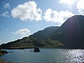
Šest desítek jezer

Název oblasti dalo zhruba šedesát jezer ledovcového původu. Wastwater je nejhlubším jezerem v Anglii (79 metrů), Windermere je nejrozlehlejší (17 km²). Další významná jezera jsou: Bassenthwaite Lake, Brotherswater, Buttermere, Coniston Water, Crummock Water, Derwent Water, Devoke Water, Elter Water, Ennerdale Water, Esthwaite Water, Grasmere, Haweswater, Loweswater, Rydal Water, Thirlmere a Ullswater.
Lake District byl osídlen už pět tisíciletí před naším letopočtem, jak o tom svědčí nález mnoha kamenných seker v údolí Great Langdale.[4] Od roku 2017 je park o rozloze 2 292 km2 součástí Světového dědictví UNESCO.[5]
Umělci
Ve zdejší pitoreskní krajině hledala inspiraci literární skupina nazývaná Jezerní básníci. Ve vesnici Near Sawrey žila autorka pohádkových knížek Beatrix Potterová, která velkou část svého jmění věnovala na ochranu místní přírody.[6] Spisovatel Arthur Ransome zasadil na jezera děj svých dobrodružných příběhů pro mládež o Amazonkách a Vlaštovkách.
Turismus
Národní park Lake District navštíví ročně šestnáct až osmnáct milionů lidí.[7] Turisty vozí po jezerech tradiční parníky, provozuje se cykloturistika i horolezectví. Vzhledem k množství biofarem a minipivovarů je oblast také oblíbeným cílem labužníků.
Fotogalerie
 (c) Peter Trimming, CC BY-SA 2.0
Hlavní ulice v městečku Windermere
 (c) Paul Lockett, CC BY-SA 2.0
Coniston Old Man od jezera Levers Water

Výstup na Scawfell Pinacle (obr. z r. 1900)
 (c) Andy Waddington, CC BY-SA 2.0
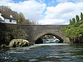
Most přes řeku Leven ve vsi Backbarrow
 (c) SteveMi, CC BY 3.0
Pohled na Great Gable ze Scafell Pike
 (c) Ron Shirt, CC BY-SA 2.0
Pleso Lambfoot Dub u Great End, v pozadí Great Gable
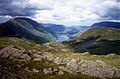
Pohled do údolí Buttermere z Grey Knotts
 (c) Peter Trimming, CC BY-SA 2.0
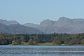
Pohled od jezera Windermere na vrcholy Langdale Pikes
 (c) K A, CC BY-SA 2.0
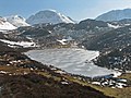
Zamrzlé pleso Blackbeck Tarn s vrcholy Green Gable a Great Gable
 (c) Michael Graham, CC BY-SA 2.0
Údolí Little Narrowcove mezi Scafell Pike a Broad Crag
Odkazy
Reference
- ↑ http://www.visitcumbria.com/squirrels/
- ↑ Archivovaná kopie. www.quido.cz [online]. [cit. 2014-03-12]. Dostupné v archivu pořízeném dne 2013-06-27.
- ↑ Archivovaná kopie. www.dandantheweatherman.com [online]. [cit. 2014-03-12]. Dostupné v archivu pořízeném dne 2015-09-23.
- ↑ http://www.megalithic.co.uk/article.php?sid=6924
- ↑ Three new sites and two extensions added to UNESCO’s World Heritage List [online]. Krakov: UNESCO, 2017-07-09 [cit. 2017-07-16]. Dostupné online. (anglicky)
- ↑ Archivovaná kopie. www.lakedistrictletsgo.co.uk [online]. [cit. 2014-03-17]. Dostupné v archivu pořízeném z originálu dne 2010-04-28.
- ↑ http://www.novinky.cz/cestovani/129027-romanticke-kouzlo-jezerni-oblasti.html
Externí odkazy
 Obrázky, zvuky či videa k tématu Jezerní oblast na Wikimedia Commons
 - http://cs.wikisource.org/wiki/Anglick%C3%A9_listy/Jezern%C3%AD_oblast
- http://www.lakedistrict.gov.uk/
- http://www.lonelyplanet.com/england/cumbria-and-the-lakes/lake-district
- http://www.nationaltrust.org.uk/visit/local-to-you/north-west/things-to-see-and-do/lake-district/
Média použitá na této stránce

Autor:
- Information-silk.png: Mark James
- derivative work: KSiOM(Talk)
A tiny blue 'i' information icon converted from the Silk icon set at famfamfam.com
.svg)

Shiny green button/marker widget.

Autor: Mactographer, Licence: Attribution
A photo I captured of Stonehenge in April of 2009.

(c) Mick Knapton from en.wikipedia.org, CC BY-SA 3.0
The Buttermere valley from Grey Knotts.
Personal photograph taken by Mick Knapton

(c) Andy Waddington, CC BY-SA 2.0
Backbarrow bridge This rather attractive bridge hides an interesting whitewater feature from the casual road user. The meat of this grade 4 drop is right underneath the bridge, making it hard to inspect at higher water levels, although a set of steps river right just above the bridge enable a climb down to get a good look if the rocks are not covered. This photo was taken after running the rapid in a pretty low water level.

(c) Peter Trimming, CC BY-SA 2.0
View Towards the Langdale Pikes The Langdale Pikes are the twin peaks towards the right of the skyline. In the middle distance, just visible above the tree line on the right of picture, is Skelwith Fold.
Autor: Thincat, Licence: CC BY-SA 3.0
Map of English Lake District showing mountain passes, mountains, lakes and vallys to accompany Wikipedia article. The background has been copied from File:Lake District National Park UK relief location map.png
_(14590722358).jpg)
Autor:
Jones, Owen Glynne; Abraham, George Dixon, 1872-; Abraham, Ashley Perry, 1876-1951;
Wordsworth Collection, Licence: No restrictionsIdentifier: cu31924103707968 (find matches)
Title: Rock-climbing in the English Lake District
Year: 1900 (1900s)
Authors: Jones, Owen Glynne Abraham, George Dixon, 1872- Abraham, Ashley Perry, 1876-1951 Wordsworth Collection
Subjects: Mountaineering
Publisher: Keswick, Cumberland, G.P. Abraham
Contributing Library: Cornell University Library
Digitizing Sponsor: MSN
View Book Page: Book Viewer
About This Book: Catalog Entry
View All Images: All Images From Book
Click here to view book online to see this illustration in context in a browseable online version of this book.
Text Appearing Before Image:
t thechimney was only iced at its entrance, and that theupper storey of the cave could be reached. Someof the others quickly followed, and we found ourselvesin a spacious chamber into which the great heap ofsnow had scarcely encroached. This was delightful.We threw ourselves into the drift that blocked themain entrance, and cut away at it with vigour till atlast we had tunnelled through to the daylight. Thebiggest man of the party yet remained outside and wepersuaded him to insert his legs into the aperture.Without giving him time to change his mind we seizedhis boots and hauled hard. For one dread momentwe thought him jammed for ever, but immediatelyafterwards we found ourselves lying on our backsin the cave with a yawning opening in the snow-drift, the while our massive friend measured hisdiminished circumference with a loop of rope. Theothers then came in and made themselves at home onropes, ice-axes, and other peoples cameras. We werea party of ten, large enough to be a merry one.
Text Appearing After Image:
FIRST PITCH, NEW ROUTE 21 Our surroundings were weird and savage, unlike theBritish notions for a Christmas Day, but I rememberthat we behaved like civilized people in perhaps onerespect. We discussed the years literature. FancyTroglodytes discussing Trilby ! Then it occurredto us that our feet were very cold, and that weshould not have much dayhght for climbing if wewaited longer. Our intention had been to climbDeep Ghyll in two separate parties, by the ordinaryway. But the drift suggested a trial of the crack upthe left-hand side of the first pitch. The snow wouldserve as a high take-off, and also a good cushion tosoften the fall if the leader were destined to fail.The first difficulty was to get safely into the crack ;then it was found that the holds were very scarce,and the recess somewhat too constricted to allow anybracing across from one side to the other. Think of a foothold ; double it. Put your wholeweight on to it as you straighten out. Take awaythe hold you thought of, and
Note About Images

(c) Peter Trimming, CC BY-SA 2.0
Main Road, Windermere. Main Road continues to the left, with Crescent Road coming in from the right. Orrest Head can just be seen on the skyline.


(c) Michael Graham, CC BY-SA 2.0
Looking into Little Narrowcove In the dip between Scafell Pike and Broad Crag.
Autor: Alexrk2, Licence: CC BY-SA 3.0
Location map of the United Kingdom

(c) K A, CC BY-SA 2.0
Blackbeck Tarn The tarn is completely frozen over as late in the winter as March 7th. Green Gable and Great Gable are on the skyline
Autor: Diliff, Licence: CC BY-SA 3.0
A 2 × 3 segment panorama of the town of Keswick, nestled between Derwent Water and the fells of Skiddaw in the Lake District, Cumbria, England. Taken from about 3/4 of the way to the summit of Walla Crag.

(c) Ron Shirt, CC BY-SA 2.0
Lambfoot Dub. Famous small Tarn under Great End. Great Gable in view.

(c) Paul Lockett, CC BY-SA 2.0
Coniston Old Man from Levers Water