Jihopatagonské ledovcové pole
| Jihopatagonské ledovcové pole | |
|---|---|
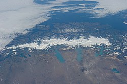
 Pohled na ledovcové pole z ISS | |
| Stát | |
| Souřadnice | 49°29′38″ j. š., 73°16′14″ z. d. |
| Některá data mohou pocházet z datové položky. | |
Jihopatagonské ledovcové pole (španělsky Campo de hielo Patagónico Sur) je rozsáhlé území pokryté ledovcem v jižním Chile, menší částí zasahuje i na argentinské území. Nachází se v Patagonských Andách, ve směru sever-jih měří přibližně 360 km, v západo-východním směru měří až 90 km a jeho rozloha je odhadována na 13 000 km².[1]
Součástí Jihopatagonského ledovcového pole jsou např. ledovce Upsala, Viedma, Perito Moreno (Argentina) a Jorge Montt, Pío XI, O'Higgins, Bernardo, Tyndall, Grey (Chile). Zatímco voda ze západní strany ledovcového pole stéká do fjordů Tichého oceánu, východní svahy sousedí s ledovcovými jezery Viedma, Argentino a Buenos Aires / General Carrera.
Podstatná část jeho plochy byla vyhlášena za chráněné území: mimo jiné národní parky Los Glaciares (Argentina, světové přírodní dědictví UNESCO), Bernardo O'Higgins (Chile) a Torres del Paine (Chile).
Odkazy
Reference
- ↑ Spatial and temporal variations of glacier extent across the Southern Patagonian Icefield since the 1970s [online]. Department of Geography, University of Ottawa, Ottawa, Ontario, Canada: The Cryosphere Discussions [cit. 2015-12-29]. Dostupné online. (anglicky)
Související články
Externí odkazy
 Obrázky, zvuky či videa k tématu Jihopatagonské ledovcové pole na Wikimedia Commons
Média použitá na této stránce
Při zobrazení tohoto souboru lze snadno přidat orámování
This grand panorama of the Southern Patagonia Icefield (center) was imaged by an Expedition 38 crew member on the International Space Station on one of the rare clear days in the southern Andes Mountains.
- With an area of 13,000 square kilometers, the icefield is the largest temperate ice sheet in the Southern Hemisphere. Storms that swirl into the region from the southern Pacific Ocean (top) bring rain and snow (equivalent to a total of 2-11 meters of rainfall per year) resulting in the buildup of the ice sheet shown here (center).
- During the ice ages the glaciers were far larger. Geologists now know that ice tongues extended far onto the plains in the foreground, completely filling the great Patagonian lakes on repeated occasions. Similarly, ice tongues extended into the dense network of fjords (arms of the sea) on the Pacific side of the icefield. Ice tongues today appear tiny compared to the view that an "ice age" astronaut would have seen.
- A study of the surface topography of sixty-three glaciers, based on Shuttle Radar Topography Mission (SRTM) data, compared data from 2000 to data from studies going back about 30 years (1968-1975). Many glacier tongues showed significant annual "retreat" of their ice fronts, a familiar signal of climate change. The study also revealed that the almost invisible loss by glacier thinning is far more significant in explaining ice loss. The researchers concluded that volume loss by frontal collapse is 4-10 times smaller than that caused by thinning. Scaled over the entire icefield, including frontal loss (so-called calving when ice masses collapse into the lakes), it was calculated that 13.5 cubic kilometers of ice was lost each year over the study period.
- This number becomes more meaningful compared with the rate measured in the last five years of the study (1995-2000), when the rate increased almost threefold, averaging 38.7 cubic kilometers per year. Extrapolating results from the low altitude glacier tongues implies that the high plateau ice on the spine of the Andes is thinning as well. In the decade since this study the often-imaged Upsala Glacier has retreated a further three kilometers, as shown recently in images taken by crew members aboard the space station. Glacier Pio X, named for Pope Pius X, is the only large glacier that is growing in length.
Autor: Draceane, Licence: CC BY-SA 4.0
Pohled z letadla na Chile během letu z Puerto Monttu do Punta Arenas


