Johann Baptist Homann
| Johann Baptist Homann | |
|---|---|
.jpg) Homannův portrét na rytině Johanna Wilhelma Windtera | |
| Narození | 20. března 1664 Oberkammlach nedaleo Kammlachu, Bavorské kurfiřtství |
| Úmrtí | 1. července 1724 (ve věku 60 let) Norimberk |
| Povolání | kartograf geograf rytec vydavatel |
| Nábož. vyznání | luteránství |
| Děti | Johann Christoph Homann |
| Některá data mohou pocházet z datové položky. | |
Johann Baptist Homann (20. března 1664 Oberkammlach – 1. července 1724 Norimberk) byl německý kartograf, geograf, rytec a vydavatel.
Život
Johann Baptist Homann se narodil 20. března 1664 v bavorské vesnici Oberkammlach nacházející se nedaleko obce Kammlach. Byl vychováván v jezuitské škole, avšak přestoupil k protestantismu a od roku 1687 pracoval v Norimberku jako notář. Záhy se začal věnovat rytí a kartografii, načež si v roce 1702 založil vlastní nakladatelství, které se zaměřovalo na vydávání kartografických děl a vedut.
Brzy se vypracoval mezi přední německé kartografy a v roce 1715 byl jmenován císařským geografem císaře Karla VI. a rovněž členem Pruské akademie věd v Berlíně. Johann Baptist Homann zemřel 1. července 1724 v Norimberku. Jeho vydavatelství fungovalo pod názvem Homann Erben až do roku 1848.
Dílo
Mezi jeho přední dílo patří vydání atlasu Grosser Atlas ueber die ganze Welt, jež byl vydán v roce 1716.
 Mapa Pyrenejského poloostrova vydaná okolo roku 1730

 Část Homannovi veduty zobrazující katedrálu svatého Ruperta a Virgila v Salcburku
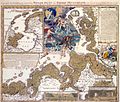
 Mapa Skandinávie vydaná okolo roku 1730
Odkazy
Literatura
- BRENNER, Karel. Kartograf Johann Baptist Homann ve službách cara Petra I. In: ŠVEJDA, Antonín. Z dějin geodézie a kartografie. Praha: Národní technické muzeum, 2011. ISBN 978-80-7037-204-3. S. 33–39.
Externí odkazy
 Obrázky, zvuky či videa k tématu Johann Baptist Homann na Wikimedia Commons
 - Digitalizovaná díla Johanna Baptisty Homanna v České digitální knihovně
Média použitá na této stránce

A detailed c. 1730 J. B. Homann map of Scandinavia. Depicts both Denmark, Norway, Sweden, Finland and the Baltic states of Livonia, Latvia and Curlandia. The map notes fortified cities, villages, roads, bridges, forests, castles and topography. The elaborate title cartouche in the upper left quadrant features angels supporting a title curtain and a medallion supporting an alternative title in French, Les Trois Covronnes du Nord . Printed in Nuremburg. This map must have been engraved before 1715 when Homann was appointed Geographer to the King. The map does not have the cum privilegio (with privilege; i.e. copyright authority given by the Emperor) as part of the title, however it was included in the c. 1750 Homann Heirs Maior Atlas Scholasticus ex Triginta Sex Generalibus et Specialibus…. as well as in Homann’s Grosser Atlas .

Salzburg, Domplatz
from: Prospectus Elegantiores Splendidissimae Archiepiscopalis Urbis Salisburgensis praecipuarumque in ea Illustrium, ac maxime mirabilium, tam Sacrarum quam profanarum Aedium

The Christmas flood of 1717

Johann Baptist Homann, Mappa di Napoli e Gaeta, incisione, 1727.
Veduta panoramica della città dal mare, arricchita in alto da quattro piccole vedute particolari della città, ed in basso dalla veduta generale e pianta di Gaeta. Seconda versione della veduta di Homann, con l’inserimento delle vedute di Gaeta in basso al luogo di quelle di Napoli. Da un punto di vista cartografico la pianta è ispirata alla prima edizione del Petrini, 1698, mentre le vedute derivano sempre dal Petrini e dal Sarnelli. Incisione in rame, Dimensioni: 574x484. Bibliografia: Grimaldi 92.

A beautifully detailed c. 1730 J. B. Homann map of Spain and Portugal. Depicts the Iberian peninsula in considerable detail including the Balearic Islands of Majorca, Minorca and Ibiza. Also covers parts of France and northern Africa. The map notes fortified cities, villages, roads, bridges, forests, castles and topography. Elaborate title cartouche in the upper right quadrant features two mermen supporting a wreath and 15 armorial crests, 14 crests for the various regions of Spain in addition to one more depicting the Spanish royal arms. Map scales in lower left quadrant. Alternative title in Spanish in top margin, El Reyno de Espanna dividido en dos grandes Estados de Argon Y de Castilla, subdividido en muchas Provincias, donde le halla tambien El Reyno de Portugal. This map was drawn in Nuremberg by J. B. Homann and included in the Homann Heirs Maior Atlas Scholasticus ex Triginta Sex Generalibus et Specialibus…. .

A stunning map of the Northern Part of Italy. Switzerland, and parts of Germany. Covers from Rome in the south, north as far as Bavaria and Bohemia, to Provence in the west, and modern day Albania in the east. This highly detailed map was constructed to illustrate the western extant of the Danube River. Printed c. 1720.