Kaldera


Kaldera je geologický útvar, který vzniká v závěru sopečné erupce. Má půdorysný tvar kruhové nebo elipsovité prohlubně, ohraničené vysokými skalními stěnami na svém okraji. Její průměr se nejčastěji pohybuje do několika kilometrů (výjimečně několik desítek kilometrů) a hloubka činní několik set metrů. Ačkoliv se kaldera vizuálně podobá sopečnému kráteru, jedná se o dvě různé povrchové formace s odlišným způsobem vzniku a rozměry.[1] Kalderizace je nejčastěji spojována s katastrofálními explozivními erupcemi pliniovského typu, kdy objem vyvrženin překračuje 1 km³.[2] Během formování kaldery obyčejně dochází k částečnému nebo úplnému zániku původního sopečného tělesa. Ovšem nejsou nutně vázány na explozivní erupce, ale vyskytují se rovněž i u štítových sopek, kde převažuje výlevný (neexplozivní) vulkanismus. Přestože každý rok dojde na Zemi zhruba k 60–80 sopečným výbuchům u 50–70 sopek,[3] patří zformování kaldery k relativně vzácným jevům, k nimž dochází pouze párkrát za století. Mezi lety 1911 a 2018 je známo pouze osm případů.[4][5]Po skončení erupce bývají působením srážek a podzemních vod často vyplněny kalderovým jezerem. S pokračující vulkanickou aktivitou se na jejich dně mohou objevit lávové dómy či může započít růst zcela nového kuželu (tzv. somma),[6][7] přičemž přísun nového materiálu je schopný v určitém časovém horizontu kalderu částečně nebo zcela zaplnit. V případě další silné erupce se může nová kaldera zformovat uvnitř stávající anebo se mohou dvě různě staré kaldery navzájem překrývat.[8] Kaldery se nutně nenacházejí jen na Zemi, ale byly objeveny i na jiných tělesech Sluneční soustavy. Dávný vulkanismus vedl k jejich vzniku na Měsíci, Venuši, Marsu, ale i jupiterově měsíci Io. Oproti těm pozemským dosahují větší velikosti.[9]
Etymologie
Slovo kaldera pochází ze španělštiny (caldera) a z latiny (caldaria). V překladu znamená kotel, odkazující na hrnec na vaření. Termín kaldera byl do geologického slovníku zaveden německým geologem Leopoldem von Buchem, když publikoval své paměti o své návštěvě Kanárských ostrovů v roce 1815. Jednalo se o Las Cañadas na ostrově Tenerife a Caldera de Taburiente na ostrově La Palma.
Vznik

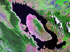
Formuje se gravitačním zhroucením (tzv. kalderizací) nadložních vrstev do uvolněného prostoru částečně vyprázdněného magmatického krbu v závěru silné sopečné erupce.[10] Erupce, která během krátké doby vyvrhne velké objemy magmatu, může způsobit významné poškození strukturální integrity magmatického krbu, což značně sníží jeho schopnost podpírat váhu nadloží nad sebou. To se působením gravitace propadne do uvolněného prostoru, což se na zemském povrchu projeví vznikem kotlovité prohlubně. Následkem toho může dojít k částečnému nebo úplnému zániku původního sopečného tělesa. Rozměry kaldery závisí na množství vyvržené hmoty a povaze erupce. Průměr většiny kalder činí několik kilometrů a jejich hloubka dosahuje několik set metrů. Největší z nich mohou mít velikost až 80 km.[9][11] Kromě explozivního vulkanismu se kalderizace objevuje taktéž u výlevného vulkanismu. Zvláštností je to, že u nich probíhá již u nízkoobjemových událostí. Sopka Fernandina na Galapágách iniciovala v roce 1968 výlev 0,2 km³ čedičové lávy, což následně zapříčinil kolaps její vrcholové části do prohlubně o průměru 5 km a hloubce 300 m.[9] Kaldery se rovněž utváří během mimořádně silných erupcí supervulkánů o síle VEI 8, kdy dojde vyvrhnutí více než 1 000 km³ sopečného materiálu.[12] Takové události jsou mimořádně vzácné, dochází k nim pouze jednou za několik desítek tisíc let,[13] naposledy před 25 600 lety. Velikost těchto kalder výrazně překračuje velikost kalder u běžných sopek. Například Yellowstonská kaldera má rozměry 70 × 45 km, zatímco kaldera Toby dokonce 100 × 30 km.[14][15] Největší kalderou světa je Apolaki, nacházející se ve Filipínském moři. Byla objevena v roce 2019 a její průměr dosahuje 150 km.[16]
Kaldery explozivního vulkanismu:
- Kaldera Tao-Rusyr se stratovulkánem Krenicyn na kurilském ostrově Onekotan.
- Aniakchak (USA)
- Pinatubo, 17 let po erupci.
- Sete Cidades (Azorské ostrovy)
Kaldery výlevného vulkanismu:
- Halemaʻumaʻu na Havajských ostrovech (USA)
- Kalderizace Halemaʻumaʻu v roce 2018
Kaldery ve Sluneční soustavě
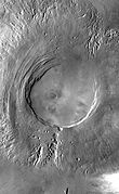
Od 60. let 20. století je známo, že vulkanismus se v minulosti vyskytoval i na jiných planetách a měsících ve Sluneční soustavě. Jeho stopy byly nalezeny na Měsíci, Venuši,[17] Marsu a na jupiterovu měsíci Io.[18] Kaldery na těchto tělesech mají stejnou strukturu jako ty pozemské, ale jiné rozměry. Průměrná velikost kalder na Venuši je 68 km, na Marsu 48 km a na Io 40 km. Kaldery na Zemi jsou tudíž nejmenší ze všech těles Sluneční soustavy.[19]
- Sacajawea Patera (Venuše)
- Apollinaris Patera (Mars)
- Arsia Mons (Mars)
- Tupan Patera (Io)
Odkazy
Reference
- ↑ B. E. Sawe. What Are The Differences Between A Volcanic Caldera And A Volcanic Crater?. https://www.worldatlas.com/ [online]. 2017-10-24. Dostupné online.
- ↑ Giuseppe Mastrolorenzo; Danilo M. Palladino; Lucia Pappalardová; Sergio Rossano. Probabilistic-Numerical assessment of pyroclastic current hazard at Campi Flegrei and Naples city: Multi-VEI scenarios as a tool for full-scale risk management [online]. PLOS One, 2017-10-11. Dostupné online. (anglicky)
- ↑ HOW MANY VOLCANIC ERUPTIONS OCCUR EVERY YEAR?. https://www.volcanodiscovery.com/ [online]. Dostupné online.
- ↑ M. T. Gudmundsson a spol. Gradual caldera collapse at Bárdarbunga volcano, Iceland, regulated by lateral magma outflow [online]. Science, 2016-07-15. Dostupné online. (anglicky)
- ↑ D. R. Shelly; W. A. Thelen. Anatomy of a Caldera Collapse: Kīlauea 2018 Summit Seismicity Sequence in High Resolution [online]. Geophysical Research Letters, 2019-12-04. Dostupné online. (anglicky)
- ↑ Robert W. Decker; Barbara B. Decker. volcano. https://www.britannica.com/ [online]. 2022-02-11. Dostupné online.
- ↑ John Seach. Somma Volcano - John Seach. http://volcanolive.com [online]. Dostupné online.
- ↑ A. Geyer; J. Martí. Stress fields controlling the formation of nested and overlapping calderas: Implications for the understanding of caldera unrest [online]. Journal of Volcanology and Geothermal Research, 2009-04-10. Dostupné online. (anglicky)
- ↑ a b c Haraldur Sigurðsson. The Encyclopedia of Volcanoes. [s.l.]: Academic Press, 2015. 1456 s. ISBN 978-0-12-385938-9. (anglicky)
- ↑ L. Krmíček. Vulkanismus : vnitřní energie Země. https://www.academia.cz/ [online]. 2022 [cit. 2024-07-13]. Dostupné v archivu pořízeném z originálu dne 2022-12-02. ISSN 2464-6245.
- ↑ V. R. Troll; T. R. Walter; H. U. Schmincke. Cyclic caldera collapse: Piston or piecemeal subsidence? Field and experimental evidence [online]. Geology, 2002-02-01. Dostupné online. (anglicky)
- ↑ Questions About Supervolcanoes. https://www.usgs.gov/ [online]. Dostupné online.
- ↑ J. Rougier; S. Sparks; K. Cashman; S. Brown. The global magnitude-frequency relationship for large explosive volcanic eruptions [online]. Earth and Planetary Science Letters, 2017-11-29. Dostupné online. (anglicky)
- ↑ R. L. Christiansen; H. R. Blank. Volcanic Stratigraphy of the Quaternary Rhyolite Plateau in Yellowstone National Park [online]. USGS, 1972. Dostupné online. (anglicky)
- ↑ C. Oppenheimer. Limited global change due to the largest known Quaternary eruption, Toba ≈74 kyr BP? [online]. Quaternary Science Reviews, 2002-08. Dostupné online. (anglicky)
- ↑ J. Barretto. Scientists discover what might be the world’s largest known caldera. https://www.gns.cri.nz [online]. 2019-07-06. Dostupné online.
- ↑ Parfitt a Wilson (2009), str. 203.
- ↑ Parfitt a Wilson (2009), str. 208.
- ↑ PARFITT, Elisabeth A.; WILSON, Lionel. Fundamentals of Physical Volcanology. [s.l.]: Blackwell Publishing company, 2009. Dostupné online. ISBN 978-0-63205443-5. Kapitola Volcanism on other planets: Mars, s. 199. (anglicky) Dále jen Parfitt a Wilson (2009).
Literatura
- SIGURDSSON, Haraldur; LIPMAN, Peter W. Encyclopedia of Volcanoes. [s.l.]: Academic Press, 1999. Dostupné online. ISBN 978-0-12-643140-7. Kapitola Calderas, s. 643-662. (anglicky)
Související články
- Altenbersko-teplická kaldera
- Yellowstonská kaldera
Externí odkazy
 Obrázky, zvuky či videa k tématu kaldera na Wikimedia Commons
Média použitá na této stránce
Aerial view west across Pinatubo caldera showing fumaroles and crater lake.
The June 12, 1991 eruption column from Mount Pinatubo taken from the east side of Clark Air Base. U.S. Geological Survey Photograph taken on June 12, 1991, 08:51 hours, by Dave Harlow.
Arsia Mons is the southernmost of the Tharsis volcanoes. It is 270 miles in diameter, almost 12 miles high, and the summit caldera is 72 miles wide. For comparison, the largest volcano on Earth is Mauna Loa. From its base on the sea floor, Mauna Loa measures only 6.3 miles high and 75 miles in diameter. The image here is a mosaic of several daytime IR images. The indentations on the SW and NE sides align with the Pavonis Mons and Ascreaus Mons to the NE. This may indicate a large fracture/vent system was responsible for the eruptions that formed all three volcanoes.
A view from the West Rim, taken near the Lightning Springs Picnic Area.
Aerial view, looking east, of Aniakchak caldera, one of the most spectacular volcanoes on the Alaska Peninsula. Formed during a catastrophic ash-flow producing eruption about 3,400 years ago, Aniakchak caldera is about 10 km (6 mi) across and averages 500 m (1,640 ft) in depth. Voluminous postcaldera eruptive activity has produced a wide variety of volcanic landforms and deposits within the caldera. The volcano is located in Aniakchak National Monument and Preserve, Alaska, which is administered by the National Park Service.
Lake Toba, Sumatra, Indonesia - Landsat satellite photo
Autor: ChrisTomnong, Licence: CC BY-SA 3.0
View from scenic lookout, early a.m.
A composite Viking orbiter image of Olympus Mons on Mars, the tallest known volcano and mountain in the Solar System.
Halemaʻumaʻu Crater in Kīlauea, Hawaii
* Left: April 13, 2018
* Right: July 28, 2018
Here's another "then and now" look at Halema‘uma‘u (view is to north). At left, Halema‘uma‘u, as we once knew it, and the active lava lake within the crater are visible on April 13, 2018. At right is a comparable viewshed captured on July 28, 2018, following recent collapses of the crater. The Hawai‘i Volcanoes National Park Jaggar Museum and USGS-HVO can be seen perched on the caldera rim (middle right) with the slopes of Mauna Loa in the background.
Russia’s Krenitsyna Volcano on Onekotan Island on August 19, 2023 photographed from ISS
Autor: Zainubrazvi, Licence: CC BY-SA 3.0
Crater Lake is a caldera lake in the south of U.S. state of Oregon. It is the main feature of Crater Lake National Park and famous for its deep blue color and water clarity. With a maximum depth of almost 1950 feet (594 m) the lake partly fills a nearly 4,000 feet (1,220 m) deep caldera that was formed around 2000 (± 150) BC by the collapse of the volcano Mount Mazama.
This Magellan image reveals Sacajawea Patera, a large, elongate caldera located in Western Ishtar Terra on the smooth plateau of Lakshmi Planum. The image is centered at 64.5 degrees North latitude and 337 degrees East longitude. It is approximately 420 kilometers (252 miles) wide at the base. Sacajawea is a depression approximately 1-2 kilometers (0.6-1.2 miles) deep and 120 x 215 kilometers (74 x 133 miles) in diameter; it is elongate in a southwest-northeast direction. The depression is bounded by a zone of circumferential curvilinear structures interpreted to be graben and fault scarps. These structures are spaced 0.5-4 kilometers (0.3-2.5 miles) apart, are 0.6-4.0 kilometers (0.4-2.5 miles) in width and up to 100 kilometers (62 miles) in length. Extending up to approximately 140 kilometers (87 miles) in length from the southeast of the patera is a system of linear structures thought to represent a flanking rift zone along which the lateral injection and eruption of magma may have occurred. A shield edifice 12 kilometers (7 miles) in diameter with a prominent central pit lies along the trend of one of these features. The impact crater Zlata, approximately 6 kilometers (4 miles) in diameter is located within the zone of graben to the northwest of the patera. Few flow features are observed in association with Sacajawea, possibly due to age and state of degradation of the flows. Mottled bright deposits 4-20 kilometers (2.5-12 miles) in width are located near the periphery and in the center of the patera floor within local topographic lows. Diffuse patches of dark material approximately 40 kilometers (25 miles) in width are observed southwest of the patera, superposed on portions of the surrounding graben. The formation of Sacajawea is thought to be related to the drainage and collapse of a large magma chamber. Gravitational relaxation may have caused the resultant caldera to sag, producing the numerous faults and graben that circumscribe the patera. Regions of complex, highly deformed tessera-like terrain are located north and east of the patera and are seen in the upper portion of the image.
the Halemaʻumaʻu plume rising from the vent and drifting towards the southwest
Mars Global Surveyor image of the Martian volcano Apollinaris Patera.
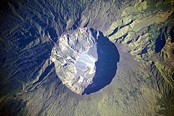
This detailed astronaut photograph depicts the summit caldera of the volcano. The huge caldera—6 kilometers in diameter and 1,100 meters deep—formed when Tambora’s estimated 4,000-meter-high peak was removed, and the magma chamber below emptied during the 1815 eruption. Today the crater floor is occupied by an ephemeral freshwater lake, recent sedimentary deposits, and minor lava flows and domes emplaced during the nineteenth and twentieth centuries. Layered tephra deposits are visible along the north-western crater rim. Active fumaroles, or steam vents, still exist in the caldera.
Detail of the volcanic crater named Tupan Patera on Jupiter's moon Io, vieweed from NASA's Galileo spacecraft. This image shows the results of lava interacting with sulfur-rich materials, and is only slightly enhanced with infrared light compared to what the human eye would actually see. This image of Tupan Patera, named after a Brazilian thunder god, was taken at a resolution of 135 meters (443 feet) per picture element (so, image width is 100 km).
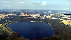
TURKEY/NEMRUT LAKE, CRATER
La Cumbre volcano, Fernandina Island, Galapagos. Photographed from the International Space Station.


